Maps of Queens County
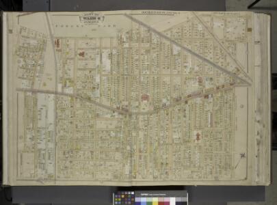
Queens, Vol. 1, Double Page Plate No. 4; Part of ward 4, Jamaica; [Map bounded by Manor Ave., Willard Ave., Magnolia Ave., Park Ave., Prospect Ave., Waterbury Ave., Garfiled Ave., Grant Ave., Cleveland Ave., Orchard Ave., Lincoln Ave., Washing
from Fourth and fifth wards: Jamaica and Rockaway.
Queens, V. 1, Double Page Plate No. 4; Part of Jamaica, Ward 4; [Map bounded by Magnolia Ave., Division Ave., Market St., Briggs Ave., Atlantic Ave., Vanderveer Pl.]
From Fourth and fifth wards: Jamaica and Rockaway.
Queens V. 4, Plate No. 22 [Map bounded by Welling, Atlantic Ave., Ocean Ave., Jamaica Ave.]
From Atlas 139. Vol. 4, 1901.
Queens V. 4, Plate No. 21 [Map bounded by Jamaica Ave., Ocean Ave., Atlantic Ave., Thrall Pl.]
From Atlas 139. Vol. 4, 1901.
Queens V. 4, Plate No. 24 [Map bounded by Jamaica Ave., Briggs Ave., Fulton Ave., Maple Ave.]
From Atlas 139. Vol. 4, 1901.
Queens V. 4, Plate No. 13 [Map bounded by Division Ave., Market, Myrtle Ave., Oak]
From Atlas 139. Vol. 4, 1901.
Queens V. 4, Plate No. 14 [Map bounded by Central Ave., Willow, Jamaica Ave., Market]
From Atlas 139. Vol. 4, 1901.
Queens V. 4, Plate No. 23 [Map bounded by Myrtle Ave., Maple Ave., Lexington Ave., Welling, Oak]
From Atlas 139. Vol. 4, 1901.
Queens V. 4, Plate No. 7 [Map bounded by Park Ave., Ferris, Woodhaven, Forest Park]
From Atlas 139. Vol. 4, 1901.
Queens V. 4, Plate No. 8 [Map bounded by Cleveland Ave., Jamaica Ave., Wookhaven Ave., Ferris]
From Atlas 139. Vol. 4, 1901.
Queens V. 4, Plate No. 41 [Map bounded by Stewart Ave., Long Island R.R. repair shops, Atlantic Ave., Beech]
From Atlas 139. Vol. 4, 1901.
Queens V. 6, Plate No. 1 [Map bounded by Metropolitan Ave., Beverly Rd., 123rd St., 85th Ave., Lefferts Blvd.]
From Atlas 142a, Vol. 6, 1911.
[Plate 32: Bounded by (Forest Park) Magnolia Avenue, Union Place, Tulip Street, Cleveland Avenue, Washington Avenue, Myrtle Avenue, Division Avenue, ... Maple Grove Cemetery, Newtown Road, Van Wyck Avenue, Atlantic Avenue and Union Place.]
from Atlas of the city of New York, borough of Queens, Long Island City, Newtown, Flushing, Jamaica, Far Rockaway, from actual surveys and official plans / by George W. and Walter S. Bromley.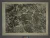
14C - N.Y. City (Aerial Set).
from Sectional aerial maps of the City of New York / [photographed and assembled under the direction of the chief engineer, July 1st, 1924].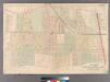
Plate 18: [Bounded by Brooklyn Jamaica Plank Road, Van Wyck Avenue, Liberty Avenue and Wyckoff Avenue.]
from Atlas of Queens Co., Long Island, New York / compiled from official records, private plans & actual surveys by and under the direction of Chester Wolverton.
Richmond Hill.
from Atlas of Long Island, New York. From recent and actual surveys and records.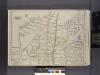
Queens, V. 1, Double Page Plate No. 5; Part of Jamaica, Ward 4; [Map bounded by Maple Grove Cemetery, Atlantic Ave., Btiggs Ave., Newtown Ward boundary line]
From Fourth and fifth wards: Jamaica and Rockaway.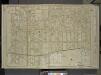
Queens, Vol. 1, Double Page Plate No. 3; Part of Ward Four, Jamaica; [Map bounded by Atlantic Ave., Napier Ave., Ocean Ave., Hopkinton Ave., Woodhaven Ave., Flushing Ave., Grafton Ave., Hatch Ave., Shattuck Ave., Oakley Ave., Lawn Ave., Union Ave.,
from Fourth and fifth wards: Jamaica and Rockaway.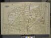
Queens, Vol. 1, Double Page Plate No. 5; Sub Plan; [Map bounded by Division Ave.; Including Market St., Church St., Richmond Hill St., Drive, Walnut St.];Part of ward 4, Jamaica; [Map bounded by Newtown Road, Whitepot Road, Cottage Ave., Richmo
from Fourth and fifth wards: Jamaica and Rockaway.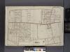
Queens, V. 1, Double Page Plate No. 1; Part of Jamaica, Ward 4; [Map bounded by Forest Park, Willard Ave., Vanderveer Pl., Atlantic Ave., Rockaway Plank Rd., Elderts Ln.]
From Fourth and fifth wards: Jamaica and Rockaway.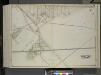
Queens, Vol. 2, Double Page Plate No. 43; Part of Ward Two Newtown; [Map bounded by Metropolitan Ave. (Williams Burg Turnpike), Ward Boundary line between Newtown and Jamaica, Myrtle Ave., Trotting Course Lane, Ocean View Ave.; Including Ma
from First and second wards: Long Island City and Newtown.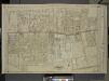
Queens, Vol. 1, Double Page Plate No. 1; Part of ward Four, Jamaica; [Map bounded by Borough of Brooklyn, Forest Park, Lott Ave., Vanerveer Ave., Leggett Ave., Road to Forest Park, Hill Side Ave., Benedic Ave., Dennington Ave., Ocean View Ave., W
from Fourth and fifth wards: Jamaica and Rockaway.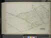
Queens, Vol. 2, Double Page Plate No. 44; Part of Ward Two Newtown; [Map bounded by Union Turnpike, Hoffman Boulevard, Lefferts Ave., Muller Ave.; Including Augustin Ave, Newtown Road, Boundary line between Jamaica and Newtown, Long Island R.
from First and second wards: Long Island City and Newtown.
Queens V. 4, Plate No. 6 [Map bounded by Jamaica Ave., Thrall Pl., Atlantic Ave., 3rd St.]
From Atlas 139. Vol. 4, 1901.
Queens V. 4, Plate No. 5 [Map bounded by Woodhaven Ave., Jamaica Ave., Ocean View Ave.]
From Atlas 139. Vol. 4, 1901.
Queens V. 4, Plate No. 43 [Map bounded by Atlantic Ave., Curtis Ave., Broadway, Beech]
From Atlas 139. Vol. 4, 1901.
Queens V. 4, Plate No. 31 [Map bounded by Atlantic Ave., Walker Ave., Broadway, Morris Ave.]
From Atlas 139. Vol. 4, 1901.
Key Continued
From Atlas 137a. Vol. 3, 1914.
Kew Gardens Hills, Utopia, Fresh Meadows, Hillcrest, Briarwood, Jamaica Hills. (cont.)
From District 8