Maps of Jersey City
Jersey City Pier.
from Combined atlas of the State of New Jersey and the County of Hudson : from actual survey, official records & private plans / by and under the direction of G. M. Hopkins ...
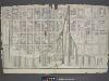
Jersey City, V. 1, Double Page Plate No. 5 [Map bounded by Washington St., Morgan St., Hudson River, Morris Canal] / compiled under the direction of and published by G.M. Hopkins Co.
From V. 1
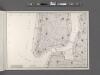
Map showing the high and low water mark and the original city grants of lands under water made to various parties from 1686 to 1873, extending from Battery to Fifty-first Street, Hudson and East Rivers, New York City, also the several pier and bulkhead l
from Whole
12A - N.Y. City (Aerial Set).
from Sectional aerial maps of the City of New York / [photographed and assembled under the direction of the chief engineer, July 1st, 1924].
[Volume 1 Index Map]
from Maps of the city of New York.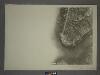
12C - N.Y. City (Aerial Set).
from Sectional aerial maps of the City of New York / [photographed and assembled under the direction of the chief engineer, July 1st, 1924].
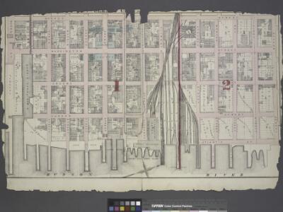
Jersey City, V. 1, Double Page Plate No. 27 [Map bounded by Morris Canal, Sussex St., Hudson River, New York Bay, Jersey Ave.] / compiled under the direction of and published by G.M. Hopkins Co.
From V. 1
Jersey City, V. 1, Double Page Plate No. 6 [Map bounded by Provost St., Ferry St., Hudson River, Morgan St., Henderson St.] / compiled under the direction of and published by G.M. Hopkins Co.
From V. 1
Jersey City, V. 1, Double Page Plate No. 2 [Map bounded by Monmouth St., 2nd St., Erie St., Grove St., Morris Canal] / compiled under the direction of and published by G.M. Hopkins Co.
From V. 1
Jersey City, V. 1, Double Page Plate No. 3 [Map bounded by Jersey Ave., 11th St., Provost St., 2nd St.] / compiled under the direction of and published by G.M. Hopkins Co.
From V. 1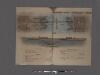
Hudson River Vehicular Tunnel [Holland Tunnel]
From Manhattan
[Volume 2 Index Map]
from Maps of the city of New York.
Area District Map Section No. 12; Area district map / City of New York, Board of Estimate and Apportionment.
from Area district map / City of New York, Board of Estimate and Apportionment. New York (N.Y.). Board of Estimate and Apportionment,
A plan of the city of New-York & its environs : to Greenwich, on the North or Hudsons River, and to Crown Point, on the East or Sound River, shewing the several streets, publick buildings, docks, fort & battery, with the true form & course of
from Charts and maps
Hooker's new pocket plan of the city of New York / compiled & surveyed by William Hooker, engraver, No. 179 Water Street, New York, house, Willoughby St., Brooklyn.
from Manhattan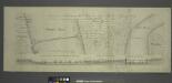
Project for a submarine rail way between New-York and Jersey-City / by Jérôme Wenmaekers.
from Whole
Plan of the city of New York in North America : surveyed in the years 1766 & 1767 / B. Ratzer, lieutt. in His Majestys 60th or Royal American Regt. ; Thos. Kitchin, sculpt., engraver to His Late Royal Highness, the Duke of York, &c.
From Manhattan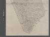
Map of New York City from Battery to 60th Street.
From Manhattan
Plan Of New York &c.
1 : 31300 Mitchell, Samuel Augustus
New map of that part of the city of New York south from 20th Street on the Hudson & 35th Street on the East River : showing the position of Greenwich, Washington and West Streets on the Hudson River, and Pearl, Water, Front, Cherry & Tompkins Sts. on the
from Manhattan
Use District Map Section No. 12
from Use district map / City of New York, Board of Estimate and Apportionment.
City of New-York / by David H. Burr.
from Manhattan
New York S.
1 : 21120 Letts, Son & Co.
Height District Map Section No. 12
from Height district map / City of New York, Board of Estimate and Apportionment.
New map of the city of New York with part of Brooklyn & Williamsburg / by J. Calvin Smith ; engraved on steel by Stiles, Sherman & Smith.
from Manhattan
Plan of the city of New York in North America : surveyed in the years 1766 & 1767 / B. Ratzer, lieutt. in His Majestys 60th or Royal American Regt. ; Thos. Kitchin, sculpt., engraver to His Late Royal Highness, the Duke of York, &c.
From Manhattan
Strangers guide through the city of New York : with the latest improvements / by H. Phelps.
from Manhattan
Map Of The City Of New York
1 : 12500 Ensign, Bridgman & Fanning
Road from Philadelphia to New York. (Maps) 14 and 15.
1 : 63360 Moore, S.S.