Maps of Yonkers
Portion of Bergen County, N.J.; Portion of City of Yonkers. And Westchester County
from Atlas of the Hudson River Valley from New York city to Troy, including a section of about 8 miles in width. Published by Watson & co. Compiled from official records and careful surveys, under the supervision of F. W. Beers.
Large folder - L1
from Atlas of New York and vicinity : from actual surveys / by and under the direction of F. W. Beers, assisted by A. B. Prindle & others
Town of Yonkers, Westchester County, New York.
1 : 39600 Beers, Frederick W.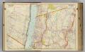
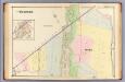
5 Bergen Co., Yonkers.
1 : 14400 Watson & Co. (New York, N.Y.)
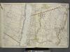
Plates 21 & 22: Town and City of Yonkers, Westchester Co. N.Y. - Town of East Chester, Westchester Co. N.Y.
From County atlas of Westchester, New York. Published by J.B. Beers & Co., assisted by S.W. Wilson and others.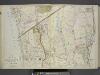
Plan of Hastings Northern part of Yonkers.
from Atlas of the Hudson River Valley from New York city to Troy, including a section of about 8 miles in width. Published by Watson & co. Compiled from official records and careful surveys, under the supervision of F. W. Beers.
Plates 21 & 22: Town and City of Yonkers, Westchester Co. N.Y. - Town of East Chester, Westchester Co. N.Y.
from County atlas of Westchester, New York. Published by J.B. Beers & Co., assisted by S.W. Wilson and others.
Yonkers and East Chester, Westchester County, New York.
1 : 23760 Beers, J.B.
Yonkers, Town.
1 : 19800 Beers, F. W. (Frederick W.)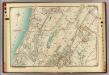
3 Atlas rural country district north of New York City.
1 : 13000 Hyde, E. Belcher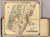
2 Yonkers.
1 : 18000 Hyde & Company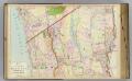
E2 Hastings, Yonkers N.
1 : 9600 Watson & Co. (New York, N.Y.)
Westchester, Double Page Plate No. 21 [Map of village of Hastings, Village of Dobbs Ferry, Village of Irvington] / prepared under the direction of Joseph R. Bien, from general surveys and official records.
From Atlas of Westchester County, New York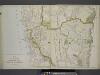
Plan of Southern part of the City of Yonkers.
from Atlas of the Hudson River Valley from New York city to Troy, including a section of about 8 miles in width. Published by Watson & co. Compiled from official records and careful surveys, under the supervision of F. W. Beers.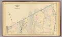
Yonkers wards 3-4.
1 : 9600 Bromley, George Washington; Bromley, Walter Scott; G.W. Bromley & Co.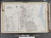
Westchester, V. 2, Double Page Plate No. 5 [Map bounded by Town of Green Hurgh, Grassy Sprain Rd., Sherman Ave., Odell Ave., Hudson River]
From Vol. 2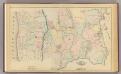
Yonkers wards 3-4.
1 : 9600 Bromley, George Washington; Bromley, Walter Scott; G.W. Bromley & Co.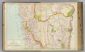
E1 Yonkers S.
1 : 9600 Watson & Co. (New York, N.Y.)
Large folder - L1
from Atlas of New York and vicinity : from actual surveys / by and under the direction of F. W. Beers, assisted by A. B. Prindle & others
Plates 34 & 35: Dobbs Ferry, Hastings upon Hudson, and Irvington.
from County atlas of Westchester, New York. Published by J.B. Beers & Co., assisted by S.W. Wilson and others.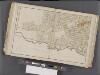
Westchester, Double Page Plate No. 11 [Map bounded by East Chester, E. 2nd St., Mount Vernon Ave., City of Yonkers] / prepared under the direction of Joseph R. Bien, from general surveys and official records.
From Atlas of Westchester County, New York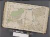
Westchester, Double Page Plate No. 12 [Map bounded by Pelham, E. 5th St., Rich Ave., East Chester] / prepared under the direction of Joseph R. Bien, from general surveys and official records.
From Atlas of Westchester County, New York
Plan of Yonkers, Town of Yonkers, Westchester County, New York.
1 : 42240 Beers, Frederick W.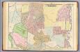
21. Yonkers.
1 : 3600 Kiser, Ellis; Mueller, A. H.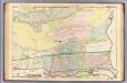
16. Yonkers.
1 : 3600 Kiser, Ellis; Mueller, A. H.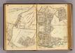
24-25 Yonkers.
1 : 7200 G.W. Bromley & Co.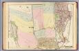
23. Yonkers.
1 : 3600 Kiser, Ellis; Mueller, A. H.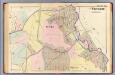
22. Yonkers.
1 : 3600 Kiser, Ellis; Mueller, A. H.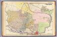
17. Yonkers.
1 : 3600 Kiser, Ellis; Mueller, A. H.