Maps of Massachusetts

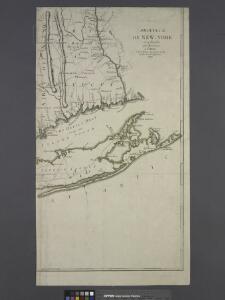
Province de New-York: en 4 feuilles / par Montrésor.
from (A-Z) John Montrésor,
Province de New-York: en 4 feuilles / par Montrésor.
from (A-Z) John Montrésor,
Massachusetts.
1 : 1900800 Scott, Joseph
Massachusetts. Rhode Island.
1 : 789000 Gray, Ormando Willis
Connecticut, from the best authorities.
from Carey's general atlas, improved and enlarged : being a collection of maps of the world and quarters, their principal empires, kingdoms, &c.
Massachusetts.
1 : 696960 Carey, Mathew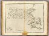
State of Massachusetts.
1 : 696960 Carey, Mathew
State of Massachusetts.
1 : 696960 Lewis, Samuel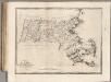
State of Massachusetts.
1 : 696960 Carey, Mathew
Massachusetts

Neueste Karte von Massachusetts und Rhode Island
Grosser Hand-Atlas über alle Theile der Erde in 170 Karten Meyer, J. Verlag des Bibliographischen Instituts
State of Massachusetts.
1 : 680000 Winterbotham, W.
Massachusetts
Connecticut
1 : 371000 Sotzmann, D. F Bey Carl Ernst Bohn
Massachusetts and Rhode Island, Vicinity of Boston.
1 : 850000 Colton, G.W.
A map of Connecticut.
from The American geography; or, A view of the present situation of the United States of America: containing astronomical geography; geographical definitions, discovery, and general description ... By Jedidiah Morse, A.M.
Colton's Massachusetts and Rhode Island
1 : 800000 G.W. & C.B. Colton & Co. G.W. & C.B. Colton & Co.
Massachusetts and Rhode Island.
1 : 800000 Tanner, Henry S.
Mass., R.I.
1 : 800000 Tanner, Henry S.
A map of the colonies of Connecticut and Rhode Island, divided into counties & townships, from the best authorities
1 : 1045440 Kitchin, Thomas Baldwin, Richard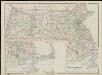
Massachusetts

National topographic map of Massachusetts and Rhode Island : showing counties, townships, cities, villages and post offices ... according to the latest census.
1 : 253440 National Map Company National Map Company
Map of Massachusetts and Rhode Island
1 : 810000 Desilver, Charles Desilver, Charles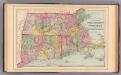
Mass., Conn., R.I.
1 : 620000 Mitchell, Samuel Augustus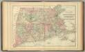
Mass., Conn., R.I.
1 : 620000 Mitchell, Samuel Augustus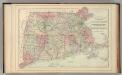
Mass., Conn., R.I.
1 : 620000 Mitchell, Samuel Augustus Jr.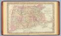
Mass., Conn., R.I.
1 : 620000 Mitchell, Samuel Augustus
Mass., Conn., R.I.
1 : 920000 Mitchell, Samuel Augustus
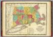
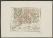
Massachusetts. Rhode Island. And Connecticut.
1 : 1647360 Burr, David H., 1803-1875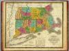
Map of Massachusetts, Connecticut, and Rhode Island.
1 : 675000 Mitchell, Samuel Augustus