Maps of Town of Warwick

Amity Village [Village]; New Millford [Village]; Edenville [Village]; Pine Island [Village]; Warwick Village [Village]
from County atlas of Orange, New York / from actual surveys by and under the direction of F.W. Beers.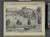
Res. of B. F. Dunning, Warwick, N.Y.
from County atlas of Orange, New York / from actual surveys by and under the direction of F.W. Beers.
Chester [Township]; Grey Court [Village]
from County atlas of Orange, New York / from actual surveys by and under the direction of F.W. Beers.
4 NE Highlands.
1 : 63360 Vermeule, C. C. (Cornelius Clarkson), 1858-1950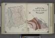
Geological Map of Passaic County, New Jersey.
from Atlas of Passaic County, New-Jersey : topographical, geological, historical, illustrated ; from actual surveys of each township and village / under the supervision of the publishers, assisted by the able engineers of Paterson.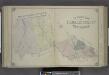
Outline Map of Passaic County, New Jersey.
from Atlas of Passaic County, New-Jersey : topographical, geological, historical, illustrated ; from actual surveys of each township and village / under the supervision of the publishers, assisted by the able engineers of Paterson.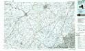
Middletown
1 : 100000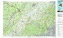
Middletown
1 : 100000
New jersey
Baker, Harriet E.
[Rockland County].
from Atlas of New York.
Orange, Rockland counties.
1 : 151000 Burr, David H., 1803-1875
Outline and Index Map of Atlas of New York City.
from Atlas of the borough of Manhattan, city of New York.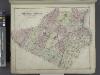
Outline Plan of Orange County New York.
from County atlas of Orange, New York / from actual surveys by and under the direction of F.W. Beers.
Map of the Hudson ... from Tarrytown to Dunderbergh.
from Map of the Hudson between Sandy Hook & Sandy Hill : with the post road between New York and Albany / Bridges delt. ; Rollinson sct.
Map of Coney Island and Sheepshead Bay.
From Brooklyn
196. New York, Washington D.C.. The World Atlas.
1 : 250000 USSR (Union of Soviet Socialist Republics).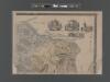
Map of Staten Island o Richmond County. 16 views of buildings on border. Also view of Elliottville the property of Dr. S. M. Elliott.
From Staten Island
Northern Part of New Jersey, shewing the the American and British Armies after crossing the North River in 1776.
1 : 290000 Marshall, John
Map of the counties of Orange and Rockland / by David H. Burr ; engd. by Rawdon, Clark & Co., Albany, & Rawdon, Wright & Co., N. York.
from An atlas of the state of New York, designed for the use of engineers, containing a map of the state and of the several counties. / Projected and drawn ... under the superintendence and direction of Simeon de Witt.
N.Y., Kings, Queens, Richmond, Rockland, Westchester, Putnam counties.
1 : 158400 Bien, Joseph Rudolf
Chief Engineer's Office. Board of Estimate and Apportionment. Index Map. Showing Location of the Sectional Plans of the City of New York.
from Height district map / City of New York, Board of Estimate and Apportionment.
Map of Long Island with the environs of New-York and the southern part of Connecticut / compiled from various surveys & documents by J. Calvin Smith ; engraved & printed by S. Stiles & Co., N. York.
From Long Island
A sketch of the operations of His Majesty's fleet and army : under the command of Vice Admiral the Rt. Hble. Lord Viscount Howe and Genl. Sr. Wm. Howe, K.B., in 1776.
from Revolutionary War, 1775-1783
Sunset Park, Bush Terminal. (cont.)
From District 7
A plan of the northern part of New Jersey : shewing the positions of the American and British armies after crossing the North River in 1776 / drawn by S. Lewis from surveys by order of Gen. Washington ; engrav'd by Fs. Shallus.
from Revolutionary War, 1775-1783
Thirty miles round the city of New York
from Whole
Westchester, Plate No. 1 [Map of Westchester County and Surroundings] / prepared under the direction of Joseph R. Bien, from general surveys and official records.
From Atlas of Westchester County, New York
Map of the counties of Orange and Rockland / by David H. Burr ; engd. by Rawdon, Clark & Co., Albany, & Rawdon, Wright & Co., N. York.
from An atlas of the state of New York : containing a map of the state and of the several counties / by David H. Burr.
Map of Long Island with the environs of New-York and the southern part of Connecticut / compiled from various surveys & documents by J. Calvin Smith ; engraved & printed by S. Stiles & Co., N. York.
From Long Island
![Amity Village [Village]; New Millford [Village]; Edenville [Village]; Pine Island [Village]; Warwick Village [Village]](https://images-2.georeferencer.com/images/iiif/003843619100/full/,300/0/native.jpg)

