Maps of Orange County

Chester Villages [Village]; Sugarloaf Village [Village]
from County atlas of Orange, New York / from actual surveys by and under the direction of F.W. Beers.
Warwick
1 : 24000
Warwick
1 : 24000
Warwick
1 : 24000
Warwick
1 : 24000
Chester [Township]; Grey Court [Village]
from County atlas of Orange, New York / from actual surveys by and under the direction of F.W. Beers.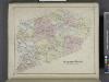
Blooming Grove [Township]
from County atlas of Orange, New York / from actual surveys by and under the direction of F.W. Beers.
Goshen
1 : 62500
Goshen
1 : 62500
Goshen
1 : 62500
Goshen
1 : 62500
Goshen
1 : 62500
Goshen
1 : 62500
Goshen
1 : 62500
Goshen
1 : 62500
Goshen
1 : 62500
4 NE Highlands.
1 : 63360 Vermeule, C. C. (Cornelius Clarkson), 1858-1950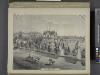
Residence of Edwin Parmelee, Bullville, Orange Co., N.Y.
from County atlas of Orange, New York / from actual surveys by and under the direction of F.W. Beers.
Middletown
1 : 100000
Middletown
1 : 100000
New jersey
Baker, Harriet E.
[Rockland County].
from Atlas of New York.
Orange, Rockland counties.
1 : 151000 Burr, David H., 1803-1875
Outline and Index Map of Atlas of New York City.
from Atlas of the borough of Manhattan, city of New York.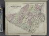
Outline Plan of Orange County New York.
from County atlas of Orange, New York / from actual surveys by and under the direction of F.W. Beers.
Map of the Hudson ... from Tarrytown to Dunderbergh.
from Map of the Hudson between Sandy Hook & Sandy Hill : with the post road between New York and Albany / Bridges delt. ; Rollinson sct.
Map of Coney Island and Sheepshead Bay.
From Brooklyn
196. New York, Washington D.C.. The World Atlas.
1 : 250000 USSR (Union of Soviet Socialist Republics).
Map of the counties of Dutchess and Putnam / by David H. Burr ; engd. by Rawdon, Clark & Co., Albany, & Rawdon, Wright & Co., New York.
from An atlas of the state of New York : containing a map of the state and of the several counties / by David H. Burr.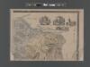
![Chester Villages [Village]; Sugarloaf Village [Village]](https://images-2.georeferencer.com/images/iiif/562347076323/full/,300/0/native.jpg)

