Maps of Newburgh
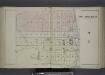
City of Newburgh N.Y. [Village]
from County atlas of Orange, New York / from actual surveys by and under the direction of F.W. Beers.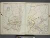
Portion of Orange County. ; Portion of Dutchess County.
from Atlas of the Hudson River Valley from New York city to Troy, including a section of about 8 miles in width. Published by Watson & co. Compiled from official records and careful surveys, under the supervision of F. W. Beers.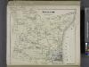
Newburgh [Township]
from County atlas of Orange, New York / from actual surveys by and under the direction of F.W. Beers.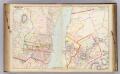
15 Orange, Dutchess counties.
1 : 14400 Watson & Co. (New York, N.Y.)
Shultzville [Village]; South Amenia [Village]; La Fayetteville [Villahe]; Fishkill [Township]; Jacksons Corners [Village]
from New illustrated atlas of Dutchess County, New York. / Compiled & drawn from personal examinations, surveys etc. under the personal supervision of O.W. Gray & Son and F.A. Davis, and published under the superintendence of H. L. Kochersperger.
Newburgh
1 : 24000
Newburgh
1 : 24000
Newburgh
1 : 24000
Newburgh
1 : 24000
Newburgh North
1 : 24000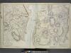
Plan of Cornwall Orange County. Spread E-W
from Atlas of the Hudson River Valley from New York city to Troy, including a section of about 8 miles in width. Published by Watson & co. Compiled from official records and careful surveys, under the supervision of F. W. Beers.
Fishkill on the Hudson [Village]
from New illustrated atlas of Dutchess County, New York. / Compiled & drawn from personal examinations, surveys etc. under the personal supervision of O.W. Gray & Son and F.A. Davis, and published under the superintendence of H. L. Kochersperger.
New Windsor [Township]; New Windsor [Village]
from County atlas of Orange, New York / from actual surveys by and under the direction of F.W. Beers.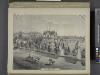
Residence of Edwin Parmelee, Bullville, Orange Co., N.Y.
from County atlas of Orange, New York / from actual surveys by and under the direction of F.W. Beers.
The Hudson by daylight map, from New York Bay to the head of tide water : containing names of streams, islands, and heights of mountains according to the latest coast survey : also the names of prominent residences, historic land marks, the old reaches o
from Hudson River
Map of Dutchess County New York
from New illustrated atlas of Dutchess County, New York. / Compiled & drawn from personal examinations, surveys etc. under the personal supervision of O.W. Gray & Son and F.A. Davis, and published under the superintendence of H. L. Kochersperger.
Dutchess, Putnam counties.
1 : 151000 Burr, David H., 1803-1875
Map of Dutchess County, New-York from original surveys / J.C. Sidney C.E., author of 12 miles around New York.
from Counties
Map of the Hudson River Rail Road from New York to Albany / engraved by Robt. Haering, N.Y. ; W.C. Moore, del.
from Hudson River
Orange, Rockland counties.
1 : 151000 Burr, David H., 1803-1875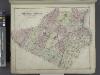
Outline Plan of Orange County New York.
from County atlas of Orange, New York / from actual surveys by and under the direction of F.W. Beers.
Map of the Hudson ... from Tarrytown to Dunderbergh.
from Map of the Hudson between Sandy Hook & Sandy Hill : with the post road between New York and Albany / Bridges delt. ; Rollinson sct.
Map of Coney Island and Sheepshead Bay.
From Brooklyn
A prospective plan of the battle fought near Lake George on the 8th of September, 1755 between 2000 English with 250 Mohawks under the command of General Johnson and 2500 French and Indians under the command of General Dieskau ...
Blodget, Samuel
Map of the counties of Dutchess and Putnam / by David H. Burr ; engd. by Rawdon, Clark & Co., Albany, & Rawdon, Wright & Co., New York.
from An atlas of the state of New York : containing a map of the state and of the several counties. / Projected and drawn under the superintendence and direction of Simeon de Witt ... And also the physical geography of the State ...
[Dutchess County].
from New York Atlas.
Map of the counties of Dutchess and Putnam / by David H. Burr ; engd. by Rawdon, Clark & Co., Albany, & Rawdon, Wright & Co., New York.
from An atlas of the state of New York : containing a map of the state and of the several counties / by David H. Burr.
Map of the county of Westchester / by David H. Burr ; engd. by Rawdon, Clark & Co., Albany, & Rawdon, Wright & Co., New York.
from An atlas of the state of New York : containing a map of the state and of the several counties. / Projected and drawn under the superintendence and direction of Simeon de Witt ... And also the physical geography of the State ...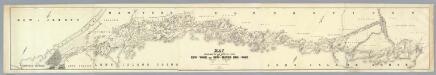
Map Exhibiting The ... Lines for the New-York and New-Haven Rail-Road.
1 : 40000 Anderson, P.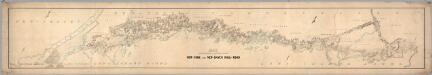
![City of Newburgh N.Y. [Village]](https://images-2.georeferencer.com/images/iiif/913367819661/full/,300/0/native.jpg)

