Maps of Hudson County
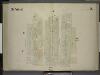
[3rd Ward. Plate 2: Map bounded by Greenwich Street, Fulton Street, Broadway, Liberty Street; Including Church St, Courtland Street, Dey Street]
from Maps of the city of New York.
Plate 7: Map bounded by Vesey Street, Broadway, Liberty Street, West Street.
from Maps of the city of New York / surveyed under directions of insurance companies of said city.
[Plate 3: Map bounded by Dey Street, Broadway, Maiden Lane, Nassau Street, Wall Street, Broadway, Rector Street, West Street]
from Maps of the city of New York.
Manhattan, V. 1, Plate No. 3 [Map bounded by Dey St., Nassau St., Rector St., Trinity Pl., Church St.]
From Atlas 107. Vol. 1, 1894.
Manhattan, V. 1, Plate No. 3 west half [Map bounded by Dey St., Trinity Pl., Church St., Rector St., West St.]
From Atlas 107. Vol. 1, 1894.
Manhattan, V. 1, Plate No. 7 [Map bounded by Murray St., Broadway, Dey St., College Pl.]
From Atlas 107. Vol. 1, 1894.
Part of Section 1 : Plate 3.
from Atlas of the borough of Manhattan, city of New York.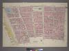
Plate 3, Part of Section 1: [Bounded by Vesey Street, Ann Street, William Street, Pine Street, Broadway, Thames Street, Greenwich Street, Carlisle Street and (Hudson River Piers) West Street.]
from Atlas of the city of New York, borough of Manhattan. From actual surveys and official plans / by George W. and Walter S. Bromley.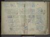
[Plate 3: Map bounded by Dey Street, Broadway, Maiden Lane, Nassau Street, Wall Street, Rector Street, West Street; Including Courtlandt Street, Liberty Street, Cedar Street, Albany Street, Thames Street, Pine Street, Carlisie Street, Washi
from Maps of the city of New-York.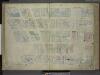
[Plate 7: Map bounded by Murray Street, Broadway, Dey Street, West Street; Including Robinson Street, Park Place, Barclay Street, Vesey Street, Fulton Street, Washington Street, Greenwich Street, College Place, Church Street]
from Maps of the city of New-York.
[Plate 7: Map bounded by Murray Street, Broadway, Dey Street, West Street]
from Maps of the city of New York.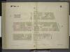
[3rd Ward. Plate 6: Map bounded by Fulton Street, Greenwich Street, Barclay Street, College Place, Park Place, Broadway; Including Vesey Street, Church Street]
from Maps of the city of New York.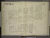
[1st & 3rd Wards. Plate E: Map bounded by West Street, Courtland Street, Greenwich Street, Liberty Street, Trinity Place, Rector Street; Including Washington Street Carlisle Street, Albany Street, Cedar Street]
from Maps of the city of New York.
Plate 3: Map bounded by Liberty Street, Nassau Street, Broad Street, Exchange Place, Broadway, Rector Street, West Street
from Maps of the city of New York / surveyed under directions of insurance companies of said city.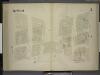
[3rd Ward. Plate 3: Map bounded by West Street, Robinson Street, College Place, Barclay Street, Greenwich Street, Courtland Street; Including Washington Street, Dey Street, Fulton Street, Vesey Street]
from Maps of the city of New York.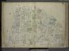
[Plate 6: Map bounded by Broadway, Park Row, Frankfort Street, Gold Street, Maiden Lane; Including Nassau Street, Theater Alley, Dutch Street, William Street, Platt Street, John Street, Fulton Street, Ann Street, Beekman Street, Spruce
from Maps of the city of New-York.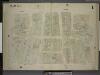
[2nd Ward. Plate 1: Map bounded by Broadway, Parks Row, Beekman Street, William Street, Liberty Street; Including Nassau Street, Theater Alley, Dutch Street, Maiden Lane, John Street, Fulton Street, Ann Street]
from Maps of the city of New York.
[Plate 6: Map bounded by City Hall Square, Frankfort Street, Gold Street, Maiden Lane, Broadway, Park Row]
from Maps of the city of New York.
[Plate 6: Map bounded by Broadway, Park Row, Spruce Street, Gold Street, Liberty Street]
from Maps of the city of New York / surveyed under directions of insurance companies of said city.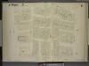
[1st Ward. Plate F: Map bounded by Liberty Street, William Street, Exchange Place, Trinity Place; Including Cedar Street, Thames Street, Pine Street, Wall Street, Temple Street, Broadway, Nassau Street, Broad Street]
from Maps of the city of New York.
Plate 9: Map bounded by Greenwich Street, Barclay Street, College Place, West Broadway, Reade Street, Broadway, Vesey Street.
from Maps of the city of New York / surveyed under directions of insurance companies of said city.
Manhattan, V. 1, Plate No. 6 south half [Map bounded by Broadway, Fulton St., Gold St., Liberty St.]
From Atlas 107. Vol. 1, 1894.
Manhattan, V. 1, Plate No. 7 west half [Map bounded by Murray St., College Pl., Dey St., West St.]
From Atlas 107. Vol. 1, 1894.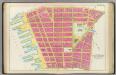
Pl. 2: wards 2-6.
1 : 1800 Bromley, George Washington; Bromley, Walter Scott
[Map bounded by Pier - Line 1-24, Vesey Street, Broadway, Battery Place; Including West Street, Washington Street, Greenwich Street, Morris Street, Rector Street, Carlisle Street, Albany Street, Cedar Street, Liberty Street, Jersey City
from Maps of the wharves and piers on the Hudson and East rivers from the Battery to 13th St., New York.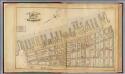
1. Ward 1,3.
1 : 2400 G.W. Bromley & Co.; Geo. W. Bromley & E. Robinson
Plate 39, Sec. 2 & Sec. 1: Plan of Hudson River Wharves. [Covers the Wharves between Perry Street - Battery Park on West Street.]
from Atlas of the city of New York, borough of Manhattan. From actual surveys and official plans / by George W. and Walter S. Bromley.
Plate 39: Bounded by Perry Street, West Street, Battery Place, State Street, Battery Park, and [Piers 1-47] Pierhead Line.
from Atlas of the borough of Manhattan, city of New York.
Part of Section 1 : New York City.
from Atlas of the city of New York, Manhattan Island. From actual surveys and official plans / by George W. and Walter S. Bromley.
![[3rd Ward. Plate 2: Map bounded by Greenwich Street, Fulton Street, Broadway, Liberty Street; Including Church St, Courtland Street, Dey Street]](https://images-2.georeferencer.com/images/iiif/144211837888/full/,300/0/native.jpg)

