Maps of Richmond County
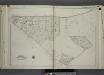
Part of Ward 4. [Map bound by Richmond Road, Grand St, Clarke Ave, Amboy Road, Tysens St, Center St]
from Atlas of the city of New York, borough of Richmond, Staten Island. From actual surveys and original plans, by George W. and Walter S. Bromley.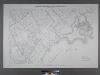
Sheet No. 78. [Includes Great Kills, Amboy Road, Midland Road, Great Kills Road, Highland Avenue, Southside Boulevard, Nelson Avenue, Duck Creek.]; Borough of Richmond, Topographical Survey.
from Borough of Richmond, Topographical Survey. Staten Island. Topographical Bureau.,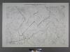
Sheet No. 70. [Includes Great Kills (Giffords), Southside Boulevard, Emmet Avenue, Washington Avenue, Lincoln Avenue,; Borough of Richmond, Topographical Survey.
from Borough of Richmond, Topographical Survey. Staten Island. Topographical Bureau.,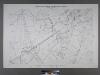
Sheet No. 77. [Includes Eltingville, Amboy Road, Wilson Avenue, Eltingville Boulevard, Lindenwood Road, Shelley Lane and Colon Avenue.]; Borough of Richmond, Topographical Survey.
from Borough of Richmond, Topographical Survey. Staten Island. Topographical Bureau.,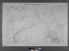
Sheet No. 69. [Includes Dewey Avenue and Giffords Lane in Great Kills.]; Borough of Richmond, Topographical Survey.
from Borough of Richmond, Topographical Survey. Staten Island. Topographical Bureau.,
Section 20
from Atlas of Staten Island, Richmond County, New York, from official records and surveys; compiled and drawn by F. W. Beers.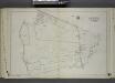
Part of Ward 4. [Map bound by Center St, Clarke Ave, St. Agnes Cemetery, Amboy Road, Staten Island R.R., Giffords Lane, Richmond Creek, Palmer Run, Arthur Kills Road (Fresh Kills RD)]
from Atlas of the city of New York, borough of Richmond, Staten Island. From actual surveys and original plans, by George W. and Walter S. Bromley.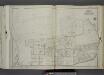
Part of Ward 3. [Map bound by London Road, Meisner Ave, Rockland Ave (Egbert), Richmond Road, Church St, Old Mill Road, Richmond Hill Road]
from Atlas of the city of New York, borough of Richmond, Staten Island. From actual surveys and original plans, by George W. and Walter S. Bromley.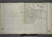
Part of Ward 4. [Map bound by Amboy Road, Bishop Ave, Dale Ave, Dorothea PL, Grace RD, Richmond Road, Locust Ave, 5th St, New Dorp Ave, 10th St, South Side Boulevard, Tysens Lane]
from Atlas of the city of New York, borough of Richmond, Staten Island. From actual surveys and original plans, by George W. and Walter S. Bromley.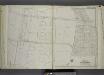
Part of Ward 4. [Map bound by Amboy Road, Cedarview Ave, Oak Ave, South Side Boulevard, 9th St, 14th St, Baldwin Ave (Jefferson Ave), Cole CT, Cole Place, Bay Terrace]
from Atlas of the city of New York, borough of Richmond, Staten Island. From actual surveys and original plans, by George W. and Walter S. Bromley.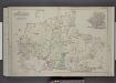
Part of Wards 2, 3, & 4. [Map bound by Forest Hill Road, New Road, Willow Brook Road, Manor Road, Ocean Terrace, Richmond Road, Amboy Road, Fresh Kills Road, Richmond Hill Road; Sub Plan - Summit Ave, Beacon Ave, Grand Ave, Walden PL, Pleasant
from Atlas of the borough of Richmond, city of New York.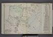
Part of Wards 4 & 5. [Map bound by Clarke Ave, Emmet Ave, Maple Ave, Lower Bay, Seaside Ave, Bridge Ave, Fresh Hills Road; Property of South New York Villa Site Co. - 1st St, Cortel You Ave, Fresh Kill Road, Richmond Ave, 21st St, Thompson Ave
from Atlas of the borough of Richmond, city of New York.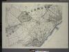
General map of the borough of Richmond (Staten Island) in the city of New York : showing in addition to the existing topographical features of the borough a tentative and preliminary plan for a street system of the same.
from Staten Island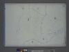
Area District Map Section No. 26
from Area district map / City of New York, Board of Estimate and Apportionment.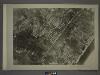
27C - N.Y. City (Aerial Set).
from Sectional aerial maps of the City of New York / [photographed and assembled under the direction of the chief engineer, July 1st, 1924].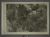
26D - N.Y. City (Aerial Set).
from Sectional aerial maps of the City of New York / [photographed and assembled under the direction of the chief engineer, July 1st, 1924].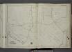
Part of Ward 3. [Map bound by Forest Hill Road (Old Mill Road), Richmond Hill Road, Klondike Ave, Rockland Ave (Saw Mill RD), Richmond Creek, Old Hill Road, Alaska PL]
from Atlas of the city of New York, borough of Richmond, Staten Island. From actual surveys and original plans, by George W. and Walter S. Bromley.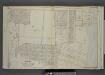
Part of Ward 4. [Map bound by New Dorp Lane, New Dorp Beach, Lower Bay, Birch Ave, Brook Ave, Amboy Road, Richmond Road]
from Atlas of the borough of Richmond, city of New York.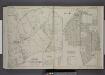
Part of Ward 5. [Map bound by Huguenot Ave, Fresh Kills Road, Bridge Ave, Staten Island Rapid Transit, Amboy Road, Foster or Rossville Ave, Wood Row Road; Sub Plan A - Annadale Road, Moffatt St, Washington Ave; Richmond ( Part of Wards 3 & 4
from Atlas of the borough of Richmond, city of New York.
Height District Map Section No. 26; Height district map / City of New York, Board of Estimate and Apportionment.
from Height district map / City of New York, Board of Estimate and Apportionment. New York (N.Y.). Board of Estimate and Apportionment,
Use District Map Section No. 26; Use district map / City of New York, Board of Estimate and Apportionment.
from Use district map / City of New York, Board of Estimate and Apportionment. New York (N.Y.). Board of Estimate and Apportionment,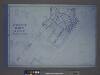
Use District Map Section No. 27; Use district map / City of New York, Board of Estimate and Apportionment.
from Use district map / City of New York, Board of Estimate and Apportionment. New York (N.Y.). Board of Estimate and Apportionment,
Area District Map Section No. 27; Area district map / City of New York, Board of Estimate and Apportionment.
from Area district map / City of New York, Board of Estimate and Apportionment. New York (N.Y.). Board of Estimate and Apportionment,
Height District Map Section No. 27; Height district map / City of New York, Board of Estimate and Apportionment.
from Height district map / City of New York, Board of Estimate and Apportionment. New York (N.Y.). Board of Estimate and Apportionment,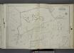
Part of Wards 2 & 3. [Map bound by Rockland Ave (Saw Mill RD), Bradley Ave (Manor RD), Washington St, Livingston Ave, Willow Brook Road (Manor RD), Manor Road, Cliffwood Ave, Todt Hill Road, Vanderbilt Pilot - Moravian Cemetery, Meisner Ave]
from Atlas of the city of New York, borough of Richmond, Staten Island. From actual surveys and original plans, by George W. and Walter S. Bromley.
Part of Southfield & Middletown.
from Atlas of Staten Island, Richmond County, New York, from official records and surveys; compiled and drawn by F. W. Beers.
Part of Northfield & Middletown.
from Atlas of Staten Island, Richmond County, New York, from official records and surveys; compiled and drawn by F. W. Beers.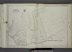
Part of Ward 2. [Map bound by Moravian Cemetery, Todt Hill Road, Flagg (Prospect Ave) PL, Richmond Road, Rockland Ave (Egbert)]
from Atlas of the city of New York, borough of Richmond, Staten Island. From actual surveys and original plans, by George W. and Walter S. Bromley.
Part of Westfield & Southfield.
from Atlas of Staten Island, Richmond County, New York, from official records and surveys; compiled and drawn by F. W. Beers.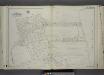
![Part of Ward 4. [Map bound by Richmond Road, Grand St, Clarke Ave, Amboy Road, Tysens St, Center St]](https://images-2.georeferencer.com/images/iiif/442265329796/full/,300/0/native.jpg)

