Maps of Richmond County
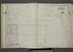
Part of Ward 4. [Map bound by The Narrows, Lower New York Bay, Richmond Ave, Tompkins Ave, Lyman Ave, Summer St, High St, Bay St (New York St)]
from Atlas of the city of New York, borough of Richmond, Staten Island. From actual surveys and original plans, by George W. and Walter S. Bromley.
Staten Island, V. 1, Plate No. 44 [Map bounded by State Ave., Tompkins Ave., Richmond Ave., Crescent Ave., Prospect Ave.]
From Atlas 162. Vol. 1, 1917.
Staten Island, V. 1, Plate No. 41 [Map bounded by St. Johns Ave., Bay, Wadsworth Ave., Tompkins Ave.]
From Atlas 162. Vol. 1, 1917.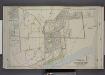
Part of Ward 4. [Map bound by Fingerboard Road, Tompkins Ave, Lyman Ave, New York Ave, Richmond Ave, Sea Ave, Seaside Boulevard, Old Town Road]
from Atlas of the borough of Richmond, city of New York.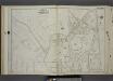
Part of Ward 4. [Map bound by Fingerboard Road, Sherman Ave, Grant Ave, Tompkins Ave, Richmond Ave, Sand Lane]
from Atlas of the city of New York, borough of Richmond, Staten Island. From actual surveys and original plans, by George W. and Walter S. Bromley.
Sheet No. 50. [Includes South Beach and Lower New York Bay.].; Borough of Richmond, Topographical Survey.
from Borough of Richmond, Topographical Survey. Staten Island. Topographical Bureau.,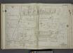
Part of Ward 4. [Map bound by Maryland Ave, New York Bay, Harbor View Place, Bay St (New York Ave), High St, Summer St, Fingerboard Road, Tompkins Ave]
from Atlas of the city of New York, borough of Richmond, Staten Island. From actual surveys and original plans, by George W. and Walter S. Bromley.
Staten Island, V. 1, Plate No. 40 [Map bounded by Hope Ave., Tompkins Ave., State Ave.]
From Atlas 162. Vol. 1, 1917.
Part of Ward 4. [Map bound by Richmond Ave, Sea Ave (Sand), Seaside Boulevard, Lower New York Bay, Staten Island Rapid Transit Rail Road, Sand Ave (Lane), Old Town Road]
from Atlas of the city of New York, borough of Richmond, Staten Island. From actual surveys and original plans, by George W. and Walter S. Bromley.
Sheet No. 42. [Includes South Beach and Lower New York Bay, McFarland Avenue, Cedar Avenue and Jackson Avenue in Arrochar.]; Borough of Richmond, Topographical Survey.
from Borough of Richmond, Topographical Survey. Staten Island. Topographical Bureau.,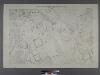
Sheet No. 41. [Includes Fingerboard Road, Old Town Road in Grasmere, Chicago Avenue, Sand Lane, Pickersgill Avenue & Cleveland Place in Arrochar.]; Borough of Richmond, Topographical Survey.
from Borough of Richmond, Topographical Survey. Staten Island. Topographical Bureau.,
Richmond, Plate No. 81 [Map bounded by Clifton Ave., New York Ave., St. Johns Ave., 4th St.]
From Atlas 160, 1898.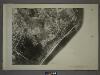
27B - N.Y. City (Aerial Set).
from Sectional aerial maps of the City of New York / [photographed and assembled under the direction of the chief engineer, July 1st, 1924].
Part of Clifton.
from Atlas of Staten Island, Richmond County, New York, from official records and surveys; compiled and drawn by F. W. Beers.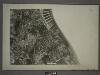
21D - N.Y. City (Aerial Set).
from Sectional aerial maps of the City of New York / [photographed and assembled under the direction of the chief engineer, July 1st, 1924].
Map of Staten Island, Richmond County, New York City, from surveys under the direction of H. F. Walling.
From Staten Island
Part of Southfield.
from Atlas of Staten Island, Richmond County, New York, from official records and surveys; compiled and drawn by F. W. Beers.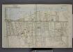
Part of Ward 4. [Map bound by Pier Line, New York Ave, Lyman Ave, Fingerboard Road, Fletcher St, Oak St, Fox Hill Golf Links, Vanderbilt Ave]
from Atlas of the borough of Richmond, city of New York.
Part of the Town of New Utrecht, Kings Co., N.Y.
from Robinson's atlas of Kings County, New York : compiled from official records ... / under the direction of E. Robinson.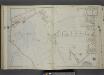
Part of Ward 4. [Map bound by Mosel Ave, Staten Island Rail Road, Rockwell Ave, Pennsylvania Ave, Clifton Ave, Tompkins Ave, Fingerboard Road, Grant Ave, Sherman Ave, Clover Ave]
from Atlas of the city of New York, borough of Richmond, Staten Island. From actual surveys and original plans, by George W. and Walter S. Bromley.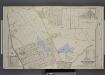
Part of Ward 4. [Map bound by Fox Hill Golf Links, Oak St, Virginia Ave, Clifton Ave, Pennsylvania Ave, Maryland Ave, Fingerboard Road, Clove Ave, Richmond Road, Vanderbilt Ave; Map bound by DeKalb, Danube Ave, Clove Ave, Richmond Road]
from Atlas of the borough of Richmond, city of New York.
Staten Island, V. 1, Plate No. 39 [Map bounded by Virginia Ave., Hope Ave., Lincoln Pl.]
From Atlas 162. Vol. 1, 1917.
Part of Ward 4. [Map bound by Chestnut Ave, Bay St (New York Ave), Sylvaton Ter., Edgewater St (Bay St), Bulkhead Line, Maryland Ave, Tompkins Ave, Pennsylvania Ave]
from Atlas of the city of New York, borough of Richmond, Staten Island. From actual surveys and original plans, by George W. and Walter S. Bromley.
Borough of Richmond, Topographical Survey.
from Borough of Richmond, Topographical Survey.
Staten Island, V. 1, Plate No. 72 [Map bounded by Richmond Ave., Sand Lane, Agnes Pl., Pearsall]
From Atlas 162. Vol. 1, 1917.
Staten Island, V. 1, Plate No. 38 [Map bounded by Chestnut Ave., Upper New York Bay, Bayview Ave., St. Johns Ave.]
From Atlas 162. Vol. 1, 1917.
General map of the borough of Richmond (Staten Island) in the city of New York : showing in addition to the existing topographical features of the borough a tentative and preliminary plan for a street system of the same.
from Staten Island
Brighton Heights, Clifton, Fort Wadsworth, Fox Hills, Grymes hill, Livingston, New Brighton, Randall Manor, Rosebank, Shore Acres, St. George, Stapleton, Tompkinsville, Ward hill, West New Brighton. (cont.)
From District 2
Map of the Marine Hospital ground, Staten Island / reduced from a survey, made by John Ewen, dated March 1845 by Daniel Ewen, city surveyor.
from Staten Island
![Part of Ward 4. [Map bound by The Narrows, Lower New York Bay, Richmond Ave, Tompkins Ave, Lyman Ave, Summer St, High St, Bay St (New York St)]](https://images-2.georeferencer.com/images/iiif/802930330015/full/,300/0/native.jpg)

