Maps of Richmond County
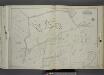
Part of Wards 2 & 3. [Map bound by Rockland Ave (Saw Mill RD), Bradley Ave (Manor RD), Washington St, Livingston Ave, Willow Brook Road (Manor RD), Manor Road, Cliffwood Ave, Todt Hill Road, Vanderbilt Pilot - Moravian Cemetery, Meisner Ave]
from Atlas of the city of New York, borough of Richmond, Staten Island. From actual surveys and original plans, by George W. and Walter S. Bromley.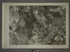
27A - N.Y. City (Aerial Set).
from Sectional aerial maps of the City of New York / [photographed and assembled under the direction of the chief engineer, July 1st, 1924].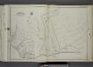
Part of Ward 2. [Map bound by Moravian Cemetery, Todt Hill Road, Flagg (Prospect Ave) PL, Richmond Road, Rockland Ave (Egbert)]
from Atlas of the city of New York, borough of Richmond, Staten Island. From actual surveys and original plans, by George W. and Walter S. Bromley.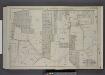
Part of Wards 2 & 3. [Map bound by Richmond Turnpike, Chestnut Ave, Todt Hill Road, Ocean Terrace, Manor Road, Egbert Ave, New Road, Willow Brook Road, Woodward Ave]
from Atlas of the borough of Richmond, city of New York.
Section 16
from Atlas of Staten Island, Richmond County, New York, from official records and surveys; compiled and drawn by F. W. Beers.
Part of Northfield & Middletown.
from Atlas of Staten Island, Richmond County, New York, from official records and surveys; compiled and drawn by F. W. Beers.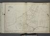
Part of Ward 2. [Map bound by Todt Hill Road, New York Ave, Benedict Ave (Atlantic Ave), Corners Road, Richmond Road, Flagg Place (Prospect Ave)]
from Atlas of the city of New York, borough of Richmond, Staten Island. From actual surveys and original plans, by George W. and Walter S. Bromley.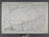
Sheet No. 54. [Includes Mill Road, Sea View Avenue, Richmond Hill, Meisner's Hill amd Elm Avenue.]; Borough of Richmond, Topographical Survey.
from Borough of Richmond, Topographical Survey. Staten Island. Topographical Bureau.,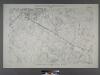
Sheet No. 61. [Includes Richmond Road, Garretson Avenue, Fresh Kills Road, Mc Kinley Avenue, Margaret Street, Laurel Avenue, Center Street and Court Street in (Richmond Town) Richmond.]; Borough of Richmond, Topographical Survey.
from Borough of Richmond, Topographical Survey. Staten Island. Topographical Bureau.,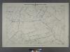
Sheet No. 46. [Includes Rockland Avenue, Forest Hill Road and port Richmond Road (Willow Brook).]; Borough of Richmond, Topographical Survey.
from Borough of Richmond, Topographical Survey. Staten Island. Topographical Bureau.,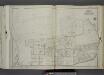
Part of Ward 3. [Map bound by London Road, Meisner Ave, Rockland Ave (Egbert), Richmond Road, Church St, Old Mill Road, Richmond Hill Road]
from Atlas of the city of New York, borough of Richmond, Staten Island. From actual surveys and original plans, by George W. and Walter S. Bromley.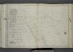
Part of Ward 2. [Map bound by Area PL, Franklin PL, Norwalk Ave, Todt Hill Road, Ocean Terrace, Redmond Ave (Fark), Benedict Ave (Atlantic Ave), New York Ave, Millard Ave, Borgert Ave, Pitt Ave, Gibson Ave, Manor Road]
from Atlas of the city of New York, borough of Richmond, Staten Island. From actual surveys and original plans, by George W. and Walter S. Bromley.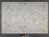
Sheet No. 47.[includes Egbert Avenue, Todt Hill Road and Dongan Hills.]; Borough of Richmond, Topographical Survey.
from Borough of Richmond, Topographical Survey. Staten Island. Topographical Bureau.,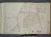
Part of Wards 1, 2 & 3. [Map bound by Forest Hill Road (Fort Richmond), Willow Brook Road (Gun Factory RD), Caswell Ave, Harvey Ave, Marble St, Byrne Ave, Buchanan Ave, Delmont St, Cedar Ave, Washington Ave, Broadway]
from Atlas of the city of New York, borough of Richmond, Staten Island. From actual surveys and original plans, by George W. and Walter S. Bromley.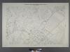
Sheet No. 55. [Includes (Egbertville), (Lighthouse Hill), Grant City and New Dorp.]; Borough of Richmond, Topographical Survey.
from Borough of Richmond, Topographical Survey. Staten Island. Topographical Bureau.,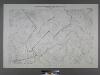
Sheet No. 70. [Includes Great Kills (Giffords), Southside Boulevard, Emmet Avenue, Washington Avenue, Lincoln Avenue,; Borough of Richmond, Topographical Survey.
from Borough of Richmond, Topographical Survey. Staten Island. Topographical Bureau.,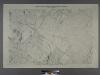
Sheet No. 62. [Includes New Dorp Lane, Southside Boulevard, Tysen's Lane, Guyon Avenue, Old Mill Road and Beach Avenue in New Dorp.]; Borough of Richmond, Topographical Survey.
from Borough of Richmond, Topographical Survey. Staten Island. Topographical Bureau.,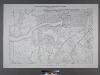
Sheet No. 60. [Includes Bridge Avenue, Fresh Kills Road and Giffords Lane.]; Borough of Richmond, Topographical Survey.
from Borough of Richmond, Topographical Survey. Staten Island. Topographical Bureau.,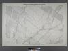
Sheet No. 53. [Includes Richmond Hill Road, Forest Hill Road, Old Stone Road and Mill Road.]; Borough of Richmond, Topographical Survey.
from Borough of Richmond, Topographical Survey. Staten Island. Topographical Bureau.,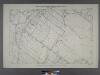
Sheet No. 45. [Includes New Springville, Bridge Avenue, Old Stone Road and Richmond Road.]; Borough of Richmond, Topographical Survey.
from Borough of Richmond, Topographical Survey. Staten Island. Topographical Bureau.,
Staten Island, V. 2, Plate No. 196 [Map of City of New York Seaview Hospital]
From Atlas 163.1. Vol. 2, 1917.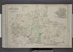
Part of Wards 2, 3, & 4. [Map bound by Forest Hill Road, New Road, Willow Brook Road, Manor Road, Ocean Terrace, Richmond Road, Amboy Road, Fresh Kills Road, Richmond Hill Road; Sub Plan - Summit Ave, Beacon Ave, Grand Ave, Walden PL, Pleasant
from Atlas of the borough of Richmond, city of New York.
Use District Map Section No. 27; Use district map / City of New York, Board of Estimate and Apportionment.
from Use district map / City of New York, Board of Estimate and Apportionment. New York (N.Y.). Board of Estimate and Apportionment,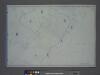
Area District Map Section No. 27; Area district map / City of New York, Board of Estimate and Apportionment.
from Area district map / City of New York, Board of Estimate and Apportionment. New York (N.Y.). Board of Estimate and Apportionment,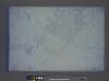
Height District Map Section No. 27; Height district map / City of New York, Board of Estimate and Apportionment.
from Height district map / City of New York, Board of Estimate and Apportionment. New York (N.Y.). Board of Estimate and Apportionment,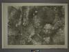
26B - N.Y. City (Aerial Set).
from Sectional aerial maps of the City of New York / [photographed and assembled under the direction of the chief engineer, July 1st, 1924].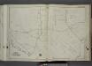
Part of Ward 3. [Map bound by Forest Hill Road (Old Mill Road), Richmond Hill Road, Klondike Ave, Rockland Ave (Saw Mill RD), Richmond Creek, Old Hill Road, Alaska PL]
from Atlas of the city of New York, borough of Richmond, Staten Island. From actual surveys and original plans, by George W. and Walter S. Bromley.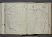
Part of Ward 3. [Map bound by Richmond Turnpike, Darcys Lane, Willow Brook Road (Gun Factory RD), Bradley Ave, Manor Road (Egbert Road), Rockland RD, Forest Hill Road (Port Richmond RD), Hotel Ave]
from Atlas of the city of New York, borough of Richmond, Staten Island. From actual surveys and original plans, by George W. and Walter S. Bromley.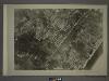
27C - N.Y. City (Aerial Set).
from Sectional aerial maps of the City of New York / [photographed and assembled under the direction of the chief engineer, July 1st, 1924].
![Part of Wards 2 & 3. [Map bound by Rockland Ave (Saw Mill RD), Bradley Ave (Manor RD), Washington St, Livingston Ave, Willow Brook Road (Manor RD), Manor Road, Cliffwood Ave, Todt Hill Road, Vanderbilt Pilot - Moravian Cemetery, Meisner Ave]](https://images-2.georeferencer.com/images/iiif/055007019911/full/,300/0/native.jpg)

