Maps of Bayonne
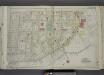
Part of Ward 3. [Map bound by Richmond Ave, Richmond Terrace, Pierhead and Bulkhead Line, Palmers Run/ Bodines Pond, Jewett Ave, Simonson PL, Anderson Ave (New York Ave), Washington PL, Albion PL]; Atlas of the city of New York, borough of Richmond, Staten Island. From actual surveys and original plans, by George W. and Walter S. Bromley.
from Atlas of the city of New York, borough of Richmond, Staten Island. From actual surveys and original plans, by George W. and Walter S. Bromley. Bromley, George Washington,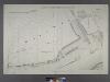
Sheet No. 2. [Includes Richmond Terrace in Staten Island, Port Johnson, New Jersey and Richmond Borough Boundary Line, and, Bayonne in New Jersey.]
from Borough of Richmond, Topographical Survey.
Jersey City, V. 1, Double Page Plate No. 38 [Map bounded by Avenue E, E. 22nd St., Kill Von Kull, Hobart Ave.] / compiled under the direction of and published by G.M. Hopkins Co.
From V. 1
Jersey City, V. 1, Double Page Plate No. 37 [Map bounded by North St., Hobart Ave., Kill Von Kull, Newark Bay] / compiled under the direction of and published by G.M. Hopkins Co.
From V. 1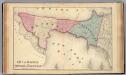
Bayonne; Greenville Twp.
1 : 19200 Beers, F. W. (Frederick W.)
General map of the borough of Richmond (Staten Island) in the city of New York : showing in addition to the existing topographical features of the borough a tentative and preliminary plan for a street system of the same.
from Staten Island
Brighton Heights, Clifton, Fort Wadsworth, Fox Hills, Grymes hill, Livingston, New Brighton, Randall Manor, Rosebank, Shore Acres, St. George, Stapleton, Tompkinsville, Ward hill, West New Brighton. (cont.)
From District 2
Map of the Village of New Brighton, Richmond Co., New York City, NY.
From Staten Island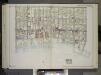
Brooklyn, Vol. 2, Double Page Plate No. 27; Part of Wards 30 & 31, Section 19; [Map bounded by 86th St., 23rd Ave., 24th Ave.; Including Gravesend Bay, 17th Ave.] / by and under the direction of Hugo Ullitz.
From Volume 2.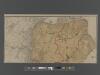
New Standard Map of the Borough of Richmond.
From Staten Island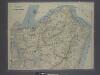
New map of Staten Island
from Staten Island
Newark, Elizabeth, the Oranges.
1 : 31680 Vermeule, C. C. (Cornelius Clarkson), 1858-1950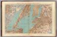
Brooklyn, N.Y. Bay, Jersey City, Hoboken, Bayonne, Newark Bay.
1 : 31680 Vermeule, C. C. (Cornelius Clarkson), 1858-1950
Richmond Co., Staten Island.
1 : 31680 Vermeule, C. C. (Cornelius Clarkson), 1858-1950
Map of property situated in the 12th ward of the city of New York belonging to the estate of John Taylor : to be sold at auction by Jas. Bleecker & Sons at the Merchts. Exchange at 12 o'clock on Tuesday the 1st April 1834.
from Manhattan
City & county map of New York, Brooklyn, Williamsburgh, Jersey City & the adjacent waters.
From Manhattan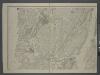
Map of New-York Bay and Harbor and the environs / founded upon a trigonometrical survey under the direction of F. R. Hassler, superintendent of the Survey of the Coast of the United States ; triangulation by James Ferguson and Edmund Blunt, assistants ;
from New York harbor
Map of the consolidated city of Brooklyn, for Bishop's manual of the corporation.
From Brooklyn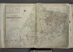
Outline & Index Map of The Borough of Richmond (Staten Island); Explanation; Note.
from Atlas of the city of New York, borough of Richmond, Staten Island. From actual surveys and original plans, by George W. and Walter S. Bromley.
City of New Manhattan : proposed May 1911, revised May 1930 / T. Kennard Thomson, consulting engineer, New York City.
from Manhattan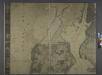
General map of the city of New York, consisting of boroughs of Manhattan, Brooklyn, Bronx, Queens and Richmond : consolidated into one municipality by act of the legislature of the state of New York (Chapter 378 of the laws of 1897) : showing in addition
from Whole
Watson's new map of the city of Brooklyn including Brooklyn
From Brooklyn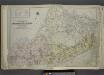
Outline & Index Map of The Borough of Richmond (Staten Island); Explanation; Note.
from Atlas of the city of New York, borough of Richmond, Staten Island. From actual surveys and original plans, by George W. and Walter S. Bromley.
Hammond's complete map of Staten Island, N.Y., Borough of Richmond, New York City.
From Staten Island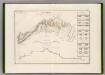
Canal Morris.
1 : 250000 Poussin, Guillaume Tell, 1794-1876
Map of a Richmond Borough Park System as recommended by the Committee on Parks of the Staten Island Chamber of Commerce.
From Staten Island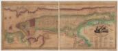
Map of the city and county of New York : with the adjacent country
1 : 20000 Burr, David H., 1803-1875 D.H. Burr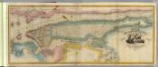
New York City & County.
1 : 20000 Burr, David H., 1803-1875
TheHome Life Publishing Co.' s map of the City of New York.
From Manhattan
![Part of Ward 3. [Map bound by Richmond Ave, Richmond Terrace, Pierhead and Bulkhead Line, Palmers Run/ Bodines Pond, Jewett Ave, Simonson PL, Anderson Ave (New York Ave), Washington PL, Albion PL]; Atlas of the city of New York, borough of Richmond, Staten Island. From actual surveys and original plans, by George W. and Walter S. Bromley.](https://images-2.georeferencer.com/images/iiif/397369236083/full/,300/0/native.jpg)

