Maps of Richmond County
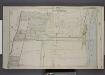
Part of Ward 4. [Map bound by Jackson Ave, Lower Bay, New Dorp Lane, Richmond Road]
from Atlas of the borough of Richmond, city of New York.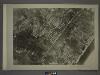
27C - N.Y. City (Aerial Set).
from Sectional aerial maps of the City of New York / [photographed and assembled under the direction of the chief engineer, July 1st, 1924].
Part of Southfield & Middletown.
from Atlas of Staten Island, Richmond County, New York, from official records and surveys; compiled and drawn by F. W. Beers.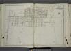
Part of Ward 4. [Map bound by Franklin Ave, 6th St, Maple Ave, Midland Beach, Lower New York Bay, New Dorp Lane, South Side Boulevard]
from Atlas of the city of New York, borough of Richmond, Staten Island. From actual surveys and original plans, by George W. and Walter S. Bromley.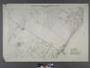
Borough of Richmond, Topographical Survey.
from Borough of Richmond, Topographical Survey.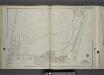
Part of Ward 4. [Map bound by Liberty Ave, Seaview Ave, Scotland Ave, New Creek, South Field Beach R.R., Maple Ave, 6th St, Franklin Ave, 9th St, South Side Boulevard]
from Atlas of the city of New York, borough of Richmond, Staten Island. From actual surveys and original plans, by George W. and Walter S. Bromley.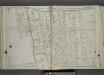
Part of Ward 4. [Map bound by Richmond Road, Stobe Ave (Jackson Ave), South Side Boulevard, Lincoln Ave, Edison St, Greeley Ave]
from Atlas of the city of New York, borough of Richmond, Staten Island. From actual surveys and original plans, by George W. and Walter S. Bromley.
Section 16
from Atlas of Staten Island, Richmond County, New York, from official records and surveys; compiled and drawn by F. W. Beers.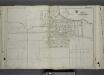
Part of Ward 4. [Map bound by Amboy Road, Bishop Ave, Dale Ave, Dorothea PL, Grace RD, Richmond Road, Locust Ave, 5th St, New Dorp Ave, 10th St, South Side Boulevard, Tysens Lane]
from Atlas of the city of New York, borough of Richmond, Staten Island. From actual surveys and original plans, by George W. and Walter S. Bromley.
Part of Ward 4. [Map bound by New Dorp Lane, New Dorp Beach, Lower New York Bay, Old Mill Road (Coles Ave), Tysens Lane, South Side Boulevard]
from Atlas of the city of New York, borough of Richmond, Staten Island. From actual surveys and original plans, by George W. and Walter S. Bromley.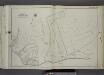
Part of Ward 2. [Map bound by Moravian Cemetery, Todt Hill Road, Flagg (Prospect Ave) PL, Richmond Road, Rockland Ave (Egbert)]
from Atlas of the city of New York, borough of Richmond, Staten Island. From actual surveys and original plans, by George W. and Walter S. Bromley.
Borough of Richmond, Topographical Survey.
from Borough of Richmond, Topographical Survey.
Sheet Nos. 72 & 87. [Sheet No. 72. Includes New Dorp Beach, Roma Avenue and Cedar Avenue. - Sheet No. 87. Includes Great Kills and Crooke's Point.]; Borough of Richmond, Topographical Survey.
from Borough of Richmond, Topographical Survey. Staten Island. Topographical Bureau.,
Sheet No. 62. [Includes New Dorp Lane, Southside Boulevard, Tysen's Lane, Guyon Avenue, Old Mill Road and Beach Avenue in New Dorp.]; Borough of Richmond, Topographical Survey.
from Borough of Richmond, Topographical Survey. Staten Island. Topographical Bureau.,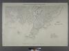
Sheet Nos. 79 & 80. [Include Oyster Island, Lockman's Creek, Flat Creek and Mill Creek Estuaries.]; Borough of Richmond, Topographical Survey.
from Borough of Richmond, Topographical Survey. Staten Island. Topographical Bureau.,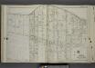
Part of Ward 4. [Map bound by Richmond Road, Old Town Road, Wilson Ave, Cornelia St, Pelton St, Evergreen Ave, Adele St, South Side Boulevard, Liberty Ave, Jefferson St, Buel Ave]
from Atlas of the city of New York, borough of Richmond, Staten Island. From actual surveys and original plans, by George W. and Walter S. Bromley.
Use District Map Section No. 27; Use district map / City of New York, Board of Estimate and Apportionment.
from Use district map / City of New York, Board of Estimate and Apportionment. New York (N.Y.). Board of Estimate and Apportionment,
Area District Map Section No. 27; Area district map / City of New York, Board of Estimate and Apportionment.
from Area district map / City of New York, Board of Estimate and Apportionment. New York (N.Y.). Board of Estimate and Apportionment,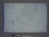
Height District Map Section No. 27; Height district map / City of New York, Board of Estimate and Apportionment.
from Height district map / City of New York, Board of Estimate and Apportionment. New York (N.Y.). Board of Estimate and Apportionment,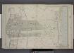
Part of Ward 4. [Map bound by Old Town Road, Seaside Boulevard, Southfield Boulevard, Richmond Road]
from Atlas of the borough of Richmond, city of New York.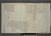
Part of Ward 4. [Map bound by New Dorp Lane, New Dorp Beach, Lower Bay, Birch Ave, Brook Ave, Amboy Road, Richmond Road]
from Atlas of the borough of Richmond, city of New York.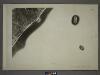
27D - N.Y. City (Aerial Set).
from Sectional aerial maps of the City of New York / [photographed and assembled under the direction of the chief engineer, July 1st, 1924].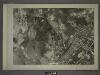
27A - N.Y. City (Aerial Set).
from Sectional aerial maps of the City of New York / [photographed and assembled under the direction of the chief engineer, July 1st, 1924].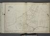
Part of Ward 2. [Map bound by Todt Hill Road, New York Ave, Benedict Ave (Atlantic Ave), Corners Road, Richmond Road, Flagg Place (Prospect Ave)]
from Atlas of the city of New York, borough of Richmond, Staten Island. From actual surveys and original plans, by George W. and Walter S. Bromley.
Part of Ward 4. [Map bound by Scott Ave, Old Town Road, South Field Beach Rail Road, New Creek, Liberty Ave, South Side Boulevard, Evergreen Ave]
from Atlas of the city of New York, borough of Richmond, Staten Island. From actual surveys and original plans, by George W. and Walter S. Bromley.
Sheet Nos. 57 & 64. [Sheet 57. Covers Midland Beach from Sea View Avenue to Poppy Joe Island. - Sheet No. 64. Includes part of Midland Beach and Lower New York bay.]
from Borough of Richmond, Topographical Survey.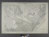
Borough of Richmond, Topographical Survey.
from Borough of Richmond, Topographical Survey.
Part of Southfield.
from Atlas of Staten Island, Richmond County, New York, from official records and surveys; compiled and drawn by F. W. Beers.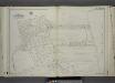
Part of Ward 4. [Map bound by Oak Ave, Mill Road, Kissam Ave, Lower New York Bay, Brook Ave, Mill Pond, South Side Boulevard]
from Atlas of the city of New York, borough of Richmond, Staten Island. From actual surveys and original plans, by George W. and Walter S. Bromley.
![Part of Ward 4. [Map bound by Jackson Ave, Lower Bay, New Dorp Lane, Richmond Road]](https://images-2.georeferencer.com/images/iiif/166071725308/full/,300/0/native.jpg)

