Maps of Richmond County
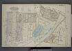
Part of Wards 1 & 2. [Map bound by Forest Ave, Brighton Ave, Castleton Ave, Woodstock St, Richmond Turnpike, Eddy St, Howard Ave, Silver Lake Park, Clove PL, Bard PL, Bard Ave, Lowell Ave]
from Atlas of the borough of Richmond, city of New York.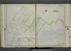
Part of Ward 1. [Map bound by Bement Ave, Harvest Ave, Revere Ave (Laurel Ave), University PL, Greenwood Ave, Forest Ave (Barrett Blvd), Reservoir North Basin, Richmond Turnpike, Clove Road]
from Atlas of the city of New York, borough of Richmond, Staten Island. From actual surveys and original plans, by George W. and Walter S. Bromley.
Borough of Richmond, Topographical Survey.
from Borough of Richmond, Topographical Survey.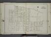
Part of Ward 1. [Map bound by Castleton Ave, Forest Ave (Brighton), Greenwood Ave, University PL, Revere Ave (Laurel Ave), Laurel Ave, Bard Ave, Lawrence Ave (Pelton Ave), Davis Ave, Pelton Ave (Lowell Ave), Shaw Ave, Bement Ave, Cary Ave]
from Atlas of the city of New York, borough of Richmond, Staten Island. From actual surveys and original plans, by George W. and Walter S. Bromley.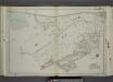
Part of Ward 2. [Map bound by Richmond Turnpike, Austin PL, Occident Ave, St. Pauls Ave, Stone St, Targee St, Purroy St (Elm St), Gordon St, Broad St, Howard Ave (Serpentine RD), Eddy St, Duncan Ave, Thressea PL]
from Atlas of the city of New York, borough of Richmond, Staten Island. From actual surveys and original plans, by George W. and Walter S. Bromley.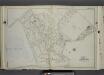
Part of Ward 1. [Map bound by Greenwood Ave, Ridgewood PL, Castleton Ave, Brighton Ave, Third St, La Fayette Ave, Prospect Ave, York Ave, Webster Ave, Cebra Ave, Richmond Turnpike, Silver Lake Reservoir]
from Atlas of the city of New York, borough of Richmond, Staten Island. From actual surveys and original plans, by George W. and Walter S. Bromley.
Sheet No. 32. [Includes Grymes Hill, (Emerson Hill) and Concord.]; Borough of Richmond, Topographical Survey.
from Borough of Richmond, Topographical Survey. Staten Island. Topographical Bureau.,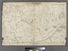
Section 7.
from Atlas of Staten Island, Richmond County, New York, from official records and surveys; compiled and drawn by F. W. Beers.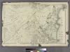
Section 8.
from Atlas of Staten Island, Richmond County, New York, from official records and surveys; compiled and drawn by F. W. Beers.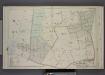
Part of Wards 1 & 2. [Map bound by Grymes Hill, Howard Ave, Woodside Ave, Centre Ave, Irving PL, Vanderbilt Ave, Richmond Road, Clove Road, Clove PL, Lakewood RD, Richmond Turnpike]
from Atlas of the borough of Richmond, city of New York.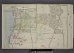
Part of Ward 1. [Map bound by Franklin Ave, Prospect Ave, "The Cedars", La Fayette Ave, Webster Ave, Castleton Ave, Brighton Ave, Forest Ave, Sailors Snug Harbor, Kill Van Kull]
from Atlas of the borough of Richmond, city of New York.
Borough of Richmond, Topographical Survey.
from Borough of Richmond, Topographical Survey.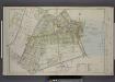
Part of Ward 2. [Map bound by Eddy St, Howard Ave, Trossach Road, St. Pauls Ave, Richmond Road, Beach St, Union PL, Cross St, Bulkhead Line, Vanderbilt Ave, Irving PL, Woodside Ave]
from Atlas of the borough of Richmond, city of New York.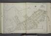
Part of Ward 2. [Map bound by Serpentine Road, Howard Ave (Serpentine RD) , Broad St, Gordon St, Tompkins St (Serpentine RD), Warren St, Pleasant PL, Vanderbilt Ave, Richmond Road, Northcole Ave, Cedar Terrace]
from Atlas of the city of New York, borough of Richmond, Staten Island. From actual surveys and original plans, by George W. and Walter S. Bromley.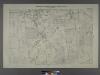
Sheet No. 31. [Includes Castleton Corners and Todt Hill.]; Borough of Richmond, Topographical Survey.
from Borough of Richmond, Topographical Survey. Staten Island. Topographical Bureau.,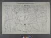
Sheet No. 10. [Includes Sailor's Snug Harbor (Livingston), Henderson Avenue, Castleton Avenue, Prospect Avenue, N.St.Austins Avenue, S. St. Austins Avenue, Brighton Avenue and Webster Avenue.]
from Borough of Richmond, Topographical Survey.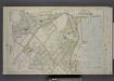
Part of Wards 1 & 2. [Map bound by Brighton Ave, York Ave, Second Ave, Westervelt Ave, Arrietta St, Pier Line, Front St, Cross St, Union St, Beach St, Richmond Road, Stone St, Trossach Road, Howard Ave, Richmond Turnpike, Woodstock Ave, Glen Ave]
from Atlas of the borough of Richmond, city of New York.
Borough of Richmond, Topographical Survey.
from Borough of Richmond, Topographical Survey.
Part of New Brighton.
from Atlas of Staten Island, Richmond County, New York, from official records and surveys; compiled and drawn by F. W. Beers.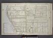
Part of Ward 1. [Map bound by Sailors Snug Harbor, Henderson Ave, Castleton Ave, Forest Ave, Broadway, Kill Van Kull]
from Atlas of the borough of Richmond, city of New York.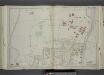
Part of Ward 1. [Map bound by Kissel Ave, Richmond Terrace, Pierhead and Bulkhead Line, La Fayette Ave, 2nd Ave, 1st Ave, Brighton Ave, Castleton Ave]
from Atlas of the city of New York, borough of Richmond, Staten Island. From actual surveys and original plans, by George W. and Walter S. Bromley.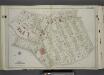
Part of Ward 1. [Map bound by Brighton Ave, York Ave, Pauw St (Centre St), Jersey St, Taft Ave (6th Ave), Westervelt Ave (Oak St), Richmond Turnpike, Cebra Ave, Castleton Ave, Wester Ave]
from Atlas of the city of New York, borough of Richmond, Staten Island. From actual surveys and original plans, by George W. and Walter S. Bromley.
Staten Island, Plate No. 13 [Map bounded by Targee, Elm, Varian, Cedar, Mc Keon]
From Atlas 159, 1885.
Staten Island, V. 1, Plate No. 29 [Map bounded by Serpentine Rd., Howard Ave., Cedar Ter.]
From Atlas 162. Vol. 1, 1917.
Height District Map Section No. 21; Height district map / City of New York, Board of Estimate and Apportionment.
from Height district map / City of New York, Board of Estimate and Apportionment. New York (N.Y.). Board of Estimate and Apportionment,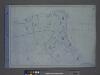
Area District Map Section No. 21; Area district map / City of New York, Board of Estimate and Apportionment.
from Area district map / City of New York, Board of Estimate and Apportionment. New York (N.Y.). Board of Estimate and Apportionment,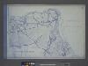
Use District Map Section No. 21; Use district map / City of New York, Board of Estimate and Apportionment.
from Use district map / City of New York, Board of Estimate and Apportionment. New York (N.Y.). Board of Estimate and Apportionment,
General map of the borough of Richmond (Staten Island) in the city of New York : showing in addition to the existing topographical features of the borough a tentative and preliminary plan for a street system of the same.
from Staten Island
Brighton Heights, Clifton, Fort Wadsworth, Fox Hills, Grymes hill, Livingston, New Brighton, Randall Manor, Rosebank, Shore Acres, St. George, Stapleton, Tompkinsville, Ward hill, West New Brighton. (cont.)
From District 2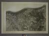
![Part of Wards 1 & 2. [Map bound by Forest Ave, Brighton Ave, Castleton Ave, Woodstock St, Richmond Turnpike, Eddy St, Howard Ave, Silver Lake Park, Clove PL, Bard PL, Bard Ave, Lowell Ave]](https://images-2.georeferencer.com/images/iiif/896694215045/full/,300/0/native.jpg)

