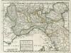
Maps of Tuscany
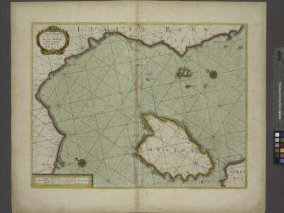
The sea coast of ITALY from cape DelleMelle to Mount Argentato with the Island of CORSICA
from The sea-atlas : containing an hydrographical description of most of the sea-coasts of the known parts of the world.
[Italien, Blatt 1]
Adolf Stieler's Handatlas über alle Theile der Erde und über das Weltgebäude Stieler, Adolf Justus Perthes
Italy North.
1 : 1550000 Hall, S. (Sidney)
Noerdliches Italien
Hand-Atlas über alle Theile der Erde nach dem neuesten Zustande und über das Weltgebäude Stieler, Adolf bei Justus Perthes
Flemming's neueste Karte des Kriegsschauplatzes in Italien
1 : 618000 Itálie severní C. Flemming
Charte von Ober- und Mittel-Italien
1 Karte : Kupferdruck ; 47 x 56 cm Götze im Verlage des Landes Industrie Comptoirs
Kaart van Sardinië
1 : 1850000 Sardinie (Itálie) Scheve, H. Hoogstraten & Gorter te Zwolle
Carta d'Italia alla scala di 1 a 1 000 000
1 : 1000000 Westblatt Istituto Geografico Militare (Firenze) Istituto Geografico Militare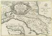
Reyse-Cart von Italien :
1 : 3000000 Mollova mapová sbírka Bodenehr, Gabriel Bodenehr, Gabriel
Northern Italy.
1 : 2217600 Colton, G.W.
Kingdom of Sardinia.
1 : 1160000 Tanner, Henry S.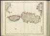
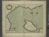
[34][34] Insularum Sardiniae et Corsicae descriptio, uit: Atlas sive Descriptio terrarum orbis
Annotatie: Gedigitaliseerde versie. Amsterdam. Heiloo : Picturae (vervaardiger), 2015. tiff-bestand. Gedigitaliseerd: 07-01-2015; Origineel: Universiteitsbibliotheek Vrije Universiteit (XL.05127.-) ; Netherlands; Titelpagina ontbreekt Wit, Frederik de Amsterdam : Frederick de Wit
A New Map of Northern Italy by W.H. Holmes.
1 : 1203840 Mitchell, Samuel Augustus
Kingdom of Sardinia
1 : 1164000 Mitchell, Samuel Augustus
Karte des Kriegschauplatzes in Italien
1 : 1800000 Itálie Dittmarsch, C. Trpog.-liter.-artist. Anstalt
Italy middle, upper.
1 : 1100000 Robert Laurie & James Whittle
Nördliches Jtalien
Stieler's Hand-Atlas Stieler, Adolf bei Justus Perthes
Le royaume de France, 6
1 Blatt : 48 x 46 cm Jaillot
Stato Della Chiesa, Con La Toscana. [Karte], in: Novus Atlas, das ist, Weltbeschreibung, Bd. 3, S. 157.
1 Karte aus Atlas Blaeu, Joan Blaeu, Willem Janszoon
Stato Della Chiesa, Con La Toscana. [Karte], in: Theatrum orbis terrarum, sive, Atlas novus, Bd. 3, S. 137.
1 Karte aus Atlas Blaeu, Joan Blaeu, Willem Janszoon
Fo. 3, uit: Carta geologica d'Italia
1 : 1000000 Rome : R. Ufficio Geologico
Weltkarte 1:1 000 000
1 : 1000000 OKH/Gen St d H
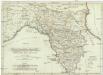
N. parts of Italy.
1 : 2750000 Bowen, Emanuel
The Signorie or Dominions of Florence.
from Abraham Ortelius his epitome of the theater of the worlde / nowe latlye ... renewed and augmented ... by Micheal Coignet, mathematitian of Antwarpe.
Übersichtskarte von Mittel - Europa
Parma, Piacenza, Guastala, mit Modena, Lukka, Massa und Carrara, dann Toskana
1 : 1050000 Carrara (Itálie) Mollo, Tranquillo Tranquillo Mollo
Nieuwe Paskaert van de Zee Kusten van Provence en Italiae
1 : 850000 Mollova mapová sbírka Keulen, Gerard van Keulen, Gerard van
Karte von Frankreich in XVI Blättern, No. 12 und [No. 16]
2 Blätter : 53 x 34 cm Königl. Preuss. Academischen Kunst und Buchhandlung
STATO DELLA | CHIESA | CON LA TOSCANA
Guiljelmus Blaeu | excudit