Maps of Africa

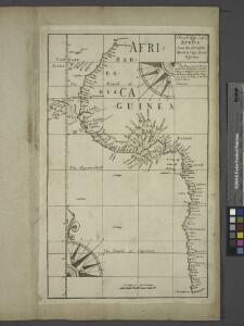
A draught of the coast of AFRICA from the streights mouth to cape bona Esprance
from The sea-atlas : containing an hydrographical description of most of the sea-coasts of the known parts of the world.
Ethnographische Karte von Afrika.
1 : 38000000 Berghaus, Heinrich
Africa.
1 : 37000000 Rand McNally and Company
Africa XVIII. Nova Tabula [Karte], in: Geographia universalis vetus et nova complectens Claudii Ptolemaei Alexandrini enarrationis libros VIII, S. 350.
1 Karte aus Atlas Münster, Sebastian [und Ptolemaeus, Claudius]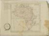
Africa XXV. Nova Tabula. [Karte], in: Claud. Ptolemaeus. Geographia lat. cum mappis [...], S. 437.
1 Karte aus Atlas Münster, Sebastian [und Ptolemaeus, Claudius]
Map of Africa, drafted and drawn by F. Handtke
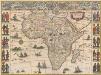
Africae nova descriptio. [Karte], in: Novus Atlas, das ist, Weltbeschreibung, Bd. 2, S. 243.
1 Karte aus Atlas Blaeu, Joan Blaeu, Willem Janszoon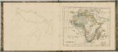
Africa
1 : 1
Afrika
E. von Sydow's Schul-Atlas in sechs und dreissig Karten Sydow, Emil von bei Justus Perthes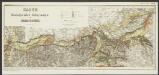
Africae nova descriptio. [Karte], in: Le théâtre du monde, ou, Nouvel atlas contenant les chartes et descriptions de tous les païs de la terre, Bd. 2, S. 281.
1 Karte aus Atlas Blaeu, Willem Janszoon und Blaeu, Joan Blaeu, Willem Janszoon
(World, gnomonic proj. I. Africa and south Europe)
1 : 5000000 Society for the Diffusion of Useful Knowledge (Great Britain)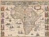
Africae nova descriptio. [Karte], in: Theatrum orbis terrarum, sive, Atlas novus, Bd. 2, S. 288.
1 Karte aus Atlas Blaeu, Joan Blaeu, Willem Janszoon
Affricae Tabvla Nova
1 : 30420000 1 Karte : Holzschnitt ; 30 x 35 cm Münster, Sebastian [Sebastian Henricpetri]
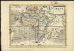
Africa.
1 : 45000000 Huntington, Hezekiah, 1795-1865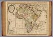
Carte d'Afrique.
1 : 21000000 L'Isle, Guillaume de, 1675-1726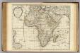
Carte d'Afrique.
1 : 21000000 L'Isle, Guillaume de, 1675-1726
Afrika
Hand-Atlas über alle Theile der Erde nach dem neuesten Zustande und über das Weltgebäude Stieler, Adolf bei Justus Perthes
Africa (political).
1 : 28990200 Fisher, Richard Swainson
107-08. Africa politica.
1 : 20000000 Touring club italiano
105-06. Africa fisica.
1 : 20000000 Touring club italiano
Afrika
Hand-Atlas über alle Theile der Erde nach dem neuesten Zustande und über das Weltgebäude Stieler, Adolf bei Justus Perthes
L'AFRIQUE
1 : 21900000 Afrika Jaillot, Alexis-Hubert chez H. Iaillot
Afrique physique
Vidal de La Blache, Paul
Carte d'Afrique / ... par Guillaume Delisle ; J. Kondet schulpsit
1 : 22500000 Isle, Guillaume de l'; Kondet, J. Amsterdam : I. Covens et C. Mortier
Africa
Schul-Atlas über alle Theile der Erde nach dem neuesten Zustande, und über das Weltgebäude Stieler, Adolf bei Justus Perthes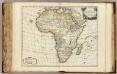
L'Afrique.
1 : 19500000 Robert de Vaugondy, Gilles, 1688-1766
Africa.
1 : 65000000 Adams, Daniel