Maps of China
A chart of the eastermost part of the EAST INDIES and CHINA, from cape comarine to IAPAN, with all adjacent Islands
from The sea-atlas : containing an hydrographical description of most of the sea-coasts of the known parts of the world.

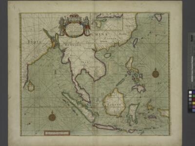
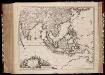
INDIA | quæ | ORIENTALIS | dicitur | ET | INSVLÆ | ADIACENTES.
[Amsterdam : Joan Blaeu]
India quae Orientalis dicitur, Et Insulae Adiacentes. [Karte], in: Le théâtre du monde, ou, Nouvel atlas contenant les chartes et descriptions de tous les païs de la terre, Bd. 2, S. 239.
1 Karte aus Atlas Blaeu, Willem Janszoon und Blaeu, Joan Blaeu, Willem Janszoon
India quae Orientalis dicitur, et Insulae Adiacentes. [Karte], in: Novus Atlas, das ist, Weltbeschreibung, Bd. 2, S. 263.
1 Karte aus Atlas Blaeu, Joan Blaeu, Willem Janszoon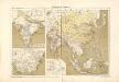
Atlas für Industrie- und Handelsgeographie: Für commercielle und technische Lehranstalten, für Kaufleute und Industrielle


India quae Orientalis dicitur, Et Insulae Adiacentes. [Karte], in: Theatrum orbis terrarum, sive, Atlas novus, Bd. 2, S. 248.
1 Karte aus Atlas Blaeu, Joan Blaeu, Willem Janszoon

Ostindien mit den Inseln
Schul-Atlas über alle Theile der Erde nach dem neuesten Zustande, und über das Weltgebäude Stieler, Adolf Justus Perthes
India quae Orientalis dicitur, et Insulae Adiacentes. [Karte], in: Novus atlas absolutissimus, Bd. 6, S. 144.
1 Karte aus Atlas Janssonius Offizin
Indiae orientalis, nec non insularum adiacentium nova descriptio
1 : 15000000 Asie jihovýchodní Visscher, Nicolaes Jansz.
Indiae orientalis, nec non insularum adiacentium nova descriptio
1 : 15000000 Asie jihovýchodní Visscher, Nicolaus per Nicolaum Visscher
Ost-Indien.
1 : 18500000 Stulpnagel, F.v.
Ostindien und China
1 : 25000000 Himálaj Kocen, Blaž Eduard Hölzel
Ost-Indien
Hand-Atlas über alle Theile der Erde und über das Weltgebäude Stieler, Adolf Justus Perthes
Ost-Indien mit den Inseln
Hand-Atlas über alle Theile der Erde nach dem neuesten Zustande und über das Weltgebäude Stieler, Adolf bei Justus Perthes
Ostindien und China
E. von Sydow's Schul-Atlas in sechs und dreissig Karten Sydow, Emil von bei Justus Perthes
Indiae Orientalis, nec non Insularum Adiacentium Nova Descriptio [Karte], in: Novus atlas absolutissimus, Bd. 9, S. 101.
1 Karte aus Atlas Janssonius Offizin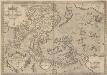
Indiae Orientalis, Insularumque Adiacientium Typus. [Karte], in: Theatrum orbis terrarum, S. 399.
1 Karte aus Atlas Ortelius, Abraham Vrients, Jan Baptista
Ost-Indien
Handatlas über alle Theile der Erde und über das Weltgebäude Stieler, Adolf Justus Perthes
Indiae Orientalis nec non insularum adiacentium nova descriptio / Per Nicolaum Visscher
1 : 15000000 Annotatie: Privilege: Cum privilegio Ordinum Hollandiae et Westfrisiae; Origineel is Blad 188 in atlas factice; Eerste staat. Later is deze kaart uitgegeven door Petrus Schenk Junior; Annotatie geografische gegevens: 2 schaalstokken, o.a. 150 Milliaria Germanica (=7,4 cm) [Amsterdam : Nicolaus Visscher]
Ostindien
Allgemeiner Atlas [Walch, Johannes] im Verlag bei Johannes Walch
Indien und Ostasien
1 : 10000000 Asie východní Verlagsanstalt List & von Bressensdorf
Map of Hindoostan, Farther India, China, and Tibet.
from Mitchell's new general atlas, containing maps of the various countries of the world, plans of cities, etc., embraced in fifty-three quarto maps., forming a series of eighty four maps and plans, together with valuable statistical tables.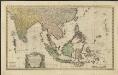
Carte des Indes Orientales
1 : 10000000 dessinée suivant les observations les plus recentes, dont le principal est tirée des cartes hydrographiques de Mr. D'Apres de Mannevillette dediée tres humblement à [...] Guillaume Charles Henry Friso [...] par [...] l'auteur et les Heritiers de Homan(n) ; S. Dorn fe. [Nürnberg] : Heritiers de Homann
Ostindien mit den Inseln
Schul-Atlas über alle Theile der Erde nach dem neuesten Zustande, und über das Weltgebäude Stieler, Adolf bei Justus Perthes
Ostindien
Neuester Schul-Atlas Walch, Johann im Verlag bei Joh. Walch