Maps of South America
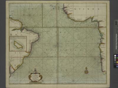
A new draught of the coast of GUINEA and BRASILE
from The sea-atlas : containing an hydrographical description of most of the sea-coasts of the known parts of the world.
South Atlantic Ocean.
1 : 25000000 John Bartholomew & Co.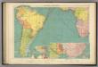
S. Atlantic Ocean.
1 : 20000000 Philip, George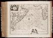
Mar di Æthiopia vulgo Oceanus Æthiopicus
1 : 22500000 Annotatie: Zeekaart; Origineel is Blad 202 in atlas factice; Annotatie geografische gegevens: Met schaalstok: Mill. Germanica Communia [Amstelodami : apud Ioannem Ianssonium]
Mar Di Aethiopia Vulgo Oceanus Aethiopicus. [Karte], in: Novus atlas absolutissimus, Bd. 9, S. 79.
1 Karte aus Atlas Janssonius Offizin
Meteorological chart of the South Atlantic Ocean
1 : 20500000 Atlantský oceán (oblast) Secretary of Agriculture
Meteorological chart of the South Atlantic Ocean
1 : 20500000 Atlantský oceán (oblast) Secretary of Agriculture
Meteorological chart of the South Atlantic Ocean
1 : 20500000 Atlantský oceán (oblast) Secretary of Agriculture
Meteorological chart of the South Atlantic Ocean
1 : 20500000 Atlantský oceán (oblast) Secretary of Agriculture
Meteorological chart of the South Atlantic Ocean
1 : 20500000 Atlantský oceán (oblast) Secretary of Agriculture
Meteorological chart of the South Atlantic Ocean
1 : 20500000 Atlantský oceán (oblast) Secretary of Agriculture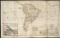
This map of South America, according to the newest and most exact observations ...
1 : 17500000
Carte de l'ocean meridional
1 Karte : Kupferdruck ; 33 x 44 cm Bellin Arkstée et Merkus
CARTE DE L'OCEAN MERIDIONAL
1 : 6700000 Atlantský oceán-oblast Bellin, Jacques-Nicolas
Pilot chart of the South Atlantic Ocean
1 : 13000000 Atlantský oceán (oblast) Maury, Matthew Fontaine Hydrographic Office
Pilot chart of the South Atlantic Ocean
1 : 13000000 Atlantský oceán (oblast) Maury, Matthew Fontaine Hydrographic Office
Pilot chart of the South Atlantic Ocean
1 : 13000000 Atlantský oceán (oblast) Maury, Matthew Fontaine Hydrographic Office
Pilot chart of the South Atlantic Ocean
1 : 13000000 Atlantský oceán (oblast) Maury, Matthew Fontaine Hydrographic Office
A draught of the coast of AFRICA from the streights mouth to cape bona Esprance
from The sea-atlas : containing an hydrographical description of most of the sea-coasts of the known parts of the world.
(World, gnomonic proj. I. Africa and south Europe)
1 : 5000000 Society for the Diffusion of Useful Knowledge (Great Britain)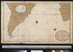
Een gedeelte van de kust van Gunea tot C. Bona Esperance, de cust van Brasielia van Parnambuco tot C. de Hoorn, als meede de kusten van Chili en Peru seer dienstig om te zijlen van C. B. Esperance tot de Straet van Magalanus
Atlantic Ocean Gerard van Keulen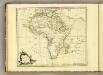
Africa.
1 : 30000000 Jefferys, Thomas
Africa (blank)
1 : 30000000 Jefferys, Thomas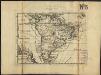
L'Amerique meridionale
1 : 1
Jižní Amerika
1 : 48260000 Jižní Amerika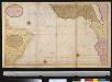
De zeekusten van Gunea van C. Verde tot Cabo de Bona Esperanco als mede de kusten van Brasil op wassende grade
Atlantic Ocean Gerard van Keulen
L'Ocean, Fernand de Noronha.
1 : 14800000 Compagnie des Indes
Carte de la partie de l'ocean vers l'equateur entre les cotes d'Afrique et d'Amerique où la situation des isles, bancs, et vigies
2 Karten auf einem Blatt : Kupferdruck ; Bildgrösse 48 x 64 cm Buache Philippe Buache
Brasil, divided into its captainships.
from New & accurate description of the earth in all its empires, kingdoms and states