Maps of Ireland
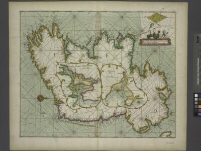
A new and correct chart of the coast of IRELAND
from The sea-atlas : containing an hydrographical description of most of the sea-coasts of the known parts of the world.
Ireland.
from A new systeme of the mathematicks: containing I. Arithmetick, as well natural and decimal, as in species, or the principles of algebra. II. Practical geometry, together with the first six books of Euclid's Elements, as also the eleventh and twelfth, symbo
The Kingdom of Ireland devided into fewer provinces...
From Ireland
A new map of Ireland, divided into its provinces, counties and baronies, wherein are distinguished the bishopricks, borroughs, barracks, bogs, passes, bridges &c. with the principal roads, and the common reputed miles.
from The world described, or, A new and correct sett of maps : shewing the kingdoms and states in all the known parts of the earth, with the principal cities, and most considerable towns in the world ... / ... by Herman Moll, geographer ...
Composite: Ireland.
1 : 700000 Lizars, Daniel
Map of Ireland.
1 : 2300000 Bowen, Emanuel
Ireland.
1 : 2750000 Seaman, James V.
Ireland.
1 : 1150000 Cary, John, ca. 1754-1835
Irlandiae regnum [Karte], in: Gerardi Mercatoris Atlas, sive, Cosmographicae meditationes de fabrica mundi et fabricati figura, S. 85.
1 Karte aus Atlas Mercator, Gerhard Montanus, Petrus
Ireland
Hand-Atlas über alle Theile der Erde nach dem neuesten Zustande und über das Weltgebäude Stieler, Adolf bei Justus Perthes
Hibernia Regnum Vulgo Ireland. [Karte], in: Novus atlas absolutissimus, Bd. 8, S. 183.
1 Karte aus Atlas Janssonius Offizin
Hibernia Regnum Vulgo Ireland. [Karte], in: Theatrum orbis terrarum, sive, Atlas novus, Bd. 4, S. 547.
1 Karte aus Atlas Blaeu, Joan Blaeu, Willem Janszoon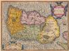
Hiberniae, Britannicae Insulae, Nova Descriptio. Irlandt. [Karte], in: Theatrum orbis terrarum, S. 42.
1 Karte aus Atlas Ortelius, Abraham
Ireland
Hand-Atlas über alle Theile der Erde nach dem neuesten Zustande und über das Weltgebäude Stieler, Adolf bei Justus Perthes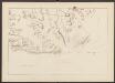
Irlandiae regnum [Karte], in: Atlas, sive, Cosmographicae meditationes de fabrica mundi et fabricati figura, S. 92.
1 Karte aus Atlas Mercator, Gerhard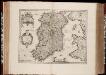
Hibernia Regnum vulgo Ireland / [Joannes Janssonius]
1 : 1300000 Annotatie: Oorspr. verschenen in: Gerardi Mercatoris et I. Hondii appendix atlas ... - Amsterdam : bey Johan Jansson, 1636; Origineel is Blad 32 in atlas factice Janssonius, Joannes (jr.) (1588-1664) Amstelodami : apud Ioannem Ianssonium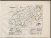
Hibernia Regnum Vulgo Ireland. [Karte], in: Le théâtre du monde, ou, Nouvel atlas contenant les chartes et descriptions de tous les païs de la terre, Bd. 3, S. 319.
1 Karte aus Atlas Blaeu, Willem Janszoon und Blaeu, Joan Blaeu, Willem Janszoon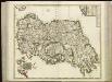
[88][88] Regnum Hiberniae ..., uit: Atlas sive Descriptio terrarum orbis
Annotatie: Gedigitaliseerde versie. Amsterdam. Heiloo : Picturae (vervaardiger), 2015. tiff-bestand. Gedigitaliseerd: 07-01-2015; Origineel: Universiteitsbibliotheek Vrije Universiteit (XL.05127.-) ; Netherlands; Titelpagina ontbreekt Wit, Frederik de Amsterdam : Frederick de Wit
Jreland
Stieler's Hand-Atlas Stieler, Adolf bei Justus Perthes
Hiberniae, Britannicae Insulae, Nova Descriptio. Irlandt. [Karte], in: Theatrum orbis terrarum, S. 89.
1 Karte aus Atlas Ortelius, Abraham Vrients, Jan Baptista
Hibernia Regnum Vulgo Ireland. [Karte], in: Novus Atlas, das ist, Weltbeschreibung, Bd. 3, S. 383.
1 Karte aus Atlas Blaeu, Joan Blaeu, Willem Janszoon


Ireland
A new general atlas of modern geography, consisting of a complete collection of maps of the four quarters of the globe Wyld, James James Wyld
Ireland.
1 : 1650000 Mitchell, Samuel Augustus
Ireland.
1 : 1650000 Mitchell, Samuel Augustus
Ireland.
1 : 1500000 Petermann, A.
49-50. Irlandia, Scozia.
1 : 1500000 Touring club italiano
Ireland.
1 : 1500000 Andree, Richard; Times (London, England)
Ireland.
1 : 1013760 Letts, Son & Co.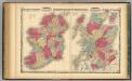
Ireland ... Scotland.
1 : 1584000 Johnson, A.J.
Ireland.
1 : 1900800 Tallis, J. & F.
Ireland.
1 : 1200000 Society for the Diffusion of Useful Knowledge (Great Britain)
Ireland.
1 : 3500000 Fenner, Rest.
Ireland.
1 : 1900000 Carey, Mathew
Ireland.
1 : 1774080 Lucas, Fielding Jr.
Ireland.
1 : 2000000 Carey, Mathew
Charte von Ireland
1 Karte : Kupferdruck ; 56 x 46 cm Kitchin; Beaufort; Jefferys im Verlage des Geographischen Instituts
Ireland (outline)
1 : 2000000 Patteson, Edward
Ireland.
1 : 2000000 Patteson, Edward
Charte von Ireland
1 Karte : Kupferdruck ; 57 x 47 cm Stieler; Beaufort in der kaiserl: privil: Kunsthandlung Adam Gottlieb Schneider und Weigels
Carte du royaume d'Irlande
1 Karte : Kupferdruck ; 72 x 50 cm Hérisson; Basset; Basset chez Basset rue St. Jacques no. 670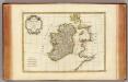
Irlande.
1 : 2400000 Bonne, Rigobert, 1727-1794
Carte ancienne et moderne de l'Irlande
1 Karte : Kupferdruck ; 33 x 28 cm Châtelain s.n.
Nouvelle carte de l'Irlande
1 Karte : Kupferdruck ; 33 x 27 cm Châtelain s.n.
Carte du gouvernement civil et militaire avec l'etat des officiers du royaume d'Irlande
2 Karten auf 1 Blatt : Kupferdruck ; je 14 x 11 cm, Bildgrösse 36 x 46 cm Châtelain s.n.
Regnum Hiberniæ
1 Karte : Kupferdruck ; 55 x 48 cm Valck; Valck Gerard und Leonardus Valck
Le royaume d'Irlande
1 Karte auf 2 Blatt : Kupferdruck ; 87 x 60 cm Jaillot; Sanson chez H. Iaillot
Le royavme d'Irlande
1 Karte : Kupferdruck ; 59 x 45 cm Coronelli; Petty; Nolin chez I. B. Nolin sur le quay de l'Horloge du Palais proche la rüe de Harlay a l'enseigne de la place des Victoires
Novissima ac præ cæteris alus accuratissima regni et insulæ Hiberniæ delineatio
1 Karte : Kupferdruck ; 70 x 48 cm Wit F. de Wit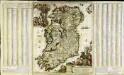
Hyberniæ regni in provincias Ultoniam, Connachiam, Lageniam, Momoniamq divisi tabula accuratissima
1 Karte auf 3 Blatt : Kupferdruck ; 57 x 49 cm, Bildgrösse 61 x 102 cm Allard by Carolus Allard op den Dam
Regnum Hiberniæ
1 Karte : Kupferdruck ; 57 x 48 cm Wit apud Fredericum de Wit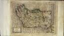
Irlandiæ regnum
1 Karte : Kupferdruck ; 17 x 24 cm Mercator Cloppenburgh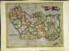
Irlandiæ regnum
1 Karte : Kupferdruck ; 31 x 40 cm Mercator; Hondius Henricus Hondius
Irlandiæ regnum
1 Karte : Kupferdruck ; 31 x 40 cm Mercator; Hondius Jodocus Hondius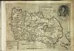
Hiberniae britan[n]icae insvlae nova descriptio
1 Karte : Kupferdruck ; 22 x 30 cm Quad; Bussemacher Johannes Bussemacher
Eryn
1 Karte : Kupferdruck ; 34 x 47 cm Ortelius s.n.