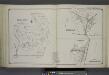
Maps of Centerport
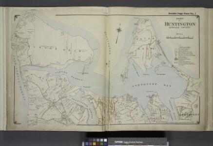
Part of Huntington Suffolk County
from Atlas of ... Suffolk County, Long Island, New York ... : based upon actual measurements by our own corps of engineers, maps on file at county offices, also maps from actual surveys furnished by individual owners / under the supervision of Merritt B. Hyde.
Lloyd Harbor
1 : 24000
Lloyd Harbor
1 : 24000
Lloyd Harbor
1 : 24000
Lloyd Harbor
1 : 24000
Northport South of Main St.
from Atlas of ... Suffolk County, Long Island, New York ... : based upon actual measurements by our own corps of engineers, maps on file at county offices, also maps from actual surveys furnished by individual owners / under the supervision of Merritt B. Hyde.
Huntington Bay.
1 : 30000 Hassler, F. R.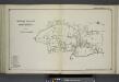
Vernon Valley and Part of Northport
from Atlas of ... Suffolk County, Long Island, New York ... : based upon actual measurements by our own corps of engineers, maps on file at county offices, also maps from actual surveys furnished by individual owners / under the supervision of Merritt B. Hyde.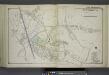
Huntington East of Nassau Ave.
from Atlas of ... Suffolk County, Long Island, New York ... : based upon actual measurements by our own corps of engineers, maps on file at county offices, also maps from actual surveys furnished by individual owners / under the supervision of Merritt B. Hyde.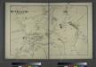
Huntington, Town of Huntington, Suffolk Co.
from Atlas of Long Island, New York. From recent and actual surveys and records.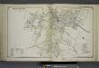
Huntington West of Nassau Ave.
from Atlas of ... Suffolk County, Long Island, New York ... : based upon actual measurements by our own corps of engineers, maps on file at county offices, also maps from actual surveys furnished by individual owners / under the supervision of Merritt B. Hyde.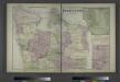
Vernon Valley, Town of Huntington, Suffolk Co.
from Atlas of Long Island, New York. From recent and actual surveys and records.
Northport
1 : 62500
Northport
1 : 62500
Northport
1 : 62500
Northport
1 : 62500
Northport
1 : 62500
Northport
1 : 62500
Northport
1 : 62500
Northport
1 : 62500
Northport
1 : 62500
Oyster or Syosset Bay.
1 : 30000 Hassler, F. R.
Northport
1 : 24000
Northport
1 : 24000
Northport
1 : 24000
Northport
1 : 24000
Northport
1 : 24000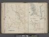
Suffolk County, V. 2, Double Page Plate No. 16 [Map bounded by Center Port, East North Port, Fair Ground] / supplemented by careful measurements & field observations by our own Corps of Engineers.
From Vol. 2, North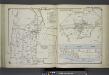
East Northport; Greenlawn; Asharoken Beach
from Atlas of ... Suffolk County, Long Island, New York ... : based upon actual measurements by our own corps of engineers, maps on file at county offices, also maps from actual surveys furnished by individual owners / under the supervision of Merritt B. Hyde.