Maps of Long Island

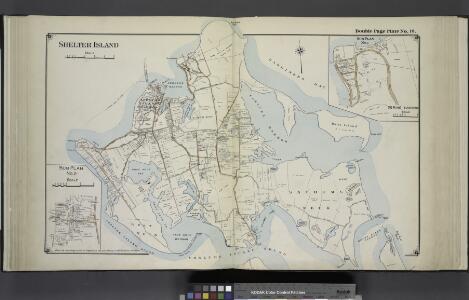
Shelter Island
from Atlas of ... Suffolk County, Long Island, New York ... : based upon actual measurements by our own corps of engineers, maps on file at county offices, also maps from actual surveys furnished by individual owners / under the supervision of Merritt B. Hyde.
Greenport
1 : 24000
Greenport
1 : 24000
Greenport
1 : 24000
Greenport
1 : 24000
Greenpoint, Town of Southold, Suffolk Co.
from Atlas of Long Island, New York. From recent and actual surveys and records.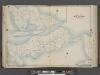
Suffolk County, V. 2, Double Page Plate No. 12 [Map bounded by Long Island Sound, Terry Pt., Orient, Gardiners Bay, Greenport Harbor] / supplemented by careful measurements & field observations by our own Corps of Engineers.
From Vol. 2, North
Southold and Shelter Island, Suffolk Co. L.I. - Village, North of Greensport, Town of Southold, Suffolk Co. - Part of Town of Southold.
from Atlas of Long Island, New York. From recent and actual surveys and records.
Shelter Island
1 : 62500
Shelter Island
1 : 62500
Shelter Island
1 : 62500
Shelter Island
1 : 62500
Shelter Island
1 : 62500
East Hampton, Suffolk Co. L.I.
from Atlas of Long Island, New York. From recent and actual surveys and records.
Part of Town of Southampton.
from Atlas of Long Island, New York. From recent and actual surveys and records.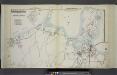
Part of Town of Southampton
from Atlas of ... Suffolk County, Long Island, New York ... : based upon actual measurements by our own corps of engineers, maps on file at county offices, also maps from actual surveys furnished by individual owners / under the supervision of Merritt B. Hyde.
Southold
1 : 24000
Southold
1 : 24000
Southold
1 : 24000
Southold
1 : 24000
Gardiners Island West
1 : 24000
Gardiners Island West
1 : 24000
Gardiners Island West
1 : 24000
Gardiners Island West
1 : 24000
Gardiners Island West
1 : 24000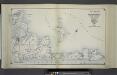
Index Map No. 2 of a part of Suffolk County. South Side - Ocean Shore, Long Island. Easthampton. Published by E. Belcher Hyde. 97 Liberty Street, Brooklyn. 5 Beekman Street, Manhattan. 1916. Volume Two.
from Atlas of ... Suffolk County, Long Island, New York ... : based upon actual measurements by our own corps of engineers, maps on file at county offices, also maps from actual surveys furnished by individual owners / under the supervision of Merritt B. Hyde.
Index Map No. 1 of a part of Suffolk County. South Side - Ocean Shore, Long Island. Southampton. Published by E. Belcher Hyde. 97 Liberty Street, Brooklyn. 5 Beekman Street, Manhattan. 1916. Volume Two.
from Atlas of ... Suffolk County, Long Island, New York ... : based upon actual measurements by our own corps of engineers, maps on file at county offices, also maps from actual surveys furnished by individual owners / under the supervision of Merritt B. Hyde.
New Haven
1 : 100000
New Haven
1 : 100000