Maps of Fire Island
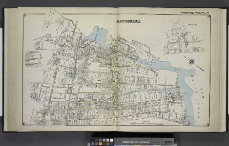
Bayshore
from Atlas of ... Suffolk County, Long Island, New York ... : based upon actual measurements by our own corps of engineers, maps on file at county offices, also maps from actual surveys furnished by individual owners / under the supervision of Merritt B. Hyde.
Brentwood. [Village]; Greenville. [Village]; Bayshore [Village]
from Atlas of the towns of Babylon, Islip, and south part of Brookhaven in Suffolk Co., N.Y. Published by Wendelken & Co., 36 Vesey street, New York ... Engraved and printed by L.E. Neuman & Co.
Bayshore, Town of Islip, Suffolk Co. - Brentwood, Town of Islip, Suffolk Co. - Bohemia, Town of Islip, Suffolk Co. - Greenville, Town of Islip, Suffolk Co. - Happauge, Town of Smithtown & Islip, Suffolk Co.
from Atlas of Long Island, New York. From recent and actual surveys and records.
Bay Shore East
1 : 24000
Bay Shore East
1 : 24000
Bay Shore East
1 : 24000
Bay Shore East
1 : 24000
Bay Shore East
1 : 24000
Islip Village and Vicinity Suffolk County, N.Y.
from Atlas of the towns of Babylon, Islip, and south part of Brookhaven in Suffolk Co., N.Y. Published by Wendelken & Co., 36 Vesey street, New York ... Engraved and printed by L.E. Neuman & Co.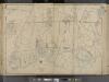
Suffolk County, V. 1, Double Page Plate No. 2 [Map bounded by Town of Smithtown, Bohemia, Nicolls Bay, Great South Bay, Town of Babylon] / supplemented by careful measurements & field observations by our own Corps of Engineers.
From Vol. 1, South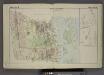
Town of Babylon. [Township]; Map of Oak & Cap Islands and Beach.
from Atlas of the towns of Babylon, Islip, and south part of Brookhaven in Suffolk Co., N.Y. Published by Wendelken & Co., 36 Vesey street, New York ... Engraved and printed by L.E. Neuman & Co.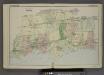
Plan of Town of Islip. [Township]
from Atlas of the towns of Babylon, Islip, and south part of Brookhaven in Suffolk Co., N.Y. Published by Wendelken & Co., 36 Vesey street, New York ... Engraved and printed by L.E. Neuman & Co.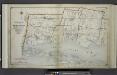
Index Map No.1 of a part of Suffolk County. South Side - Ocean Shore, Long Island. Townships of Babylon and Part of Islip Published by E. Belcher Hyde. 97 Liberty Street, Brooklyn. 5 Beekman Street, Manhattan. 1915. Volume One.
from Atlas of ... Suffolk County, Long Island, New York ... : based upon actual measurements by our own corps of engineers, maps on file at county offices, also maps from actual surveys furnished by individual owners / under the supervision of Merritt B. Hyde.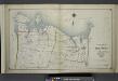
Index Map No. 1 of a part of Suffolk County. North Side - Sound Shore, Long Island. Huntington and Smith Town. Published by E. Belcher Hyde. 97 Liberty Street, Brooklyn. 5 Beekman Street, Manhattan. 1917. Volume One.
from Atlas of ... Suffolk County, Long Island, New York ... : based upon actual measurements by our own corps of engineers, maps on file at county offices, also maps from actual surveys furnished by individual owners / under the supervision of Merritt B. Hyde.
Islip
1 : 125000
Islip
1 : 125000
Islip
1 : 125000
Islip
1 : 125000
Islip
1 : 125000
Islip
1 : 125000
Topographical map of New York City, County and vicinity: showing old farm lines &c. / based on Randells and other official surveys, drawings and modern surveys by J.F. Harrison & T. Magrane; printed by C. Wadlow.
from (A-Z) J. F. Harrison; T. Magrane; C. Wadlow,
Topographical map of New York City, County and vicinity: showing old farm lines &c. / based on Randells and other official surveys, drawings and modern surveys by J.F. Harrison & T. Magrane; printed by C. Wadlow.
from (A-Z) J. F. Harrison; T. Magrane; C. Wadlow,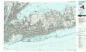
Long Island West
1 : 100000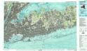
Long Island West
1 : 100000
[A chart of New York Island & North River, East River, passage through Hell Gate, Flushing Bay, Hampstead Bay, Oyster Bay, Huntington Bay, Cow Harbour, East Chester Inlet, Rochelle, Rye, Patrick Islands, &c.]
from Charts and maps
United States--east coast, New York--New Jersey, New York Harbor / Coast Survey.
United States Coast Survey,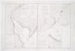
Carte de la baye et riviere de Délaware: contenant une éxacte et entiére description des rivages, criques, havres, sondes, bas-sonds, sables et les gissements des marques les plus considérables du pays depuis les Caps James et May jusqu̕à Philadelphie, suivant la carte originale, publiée en cette ville / par Josué Fischer; Depot de la marine.
from Charts and maps Josué Fischer,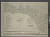
Map of New-York Bay and Harbor and the environs / founded upon a trigonometrical survey under the direction of F. R. Hassler, superintendent of the Survey of the Coast of the United States; triangulation by James Ferguson and Edmund Blunt, assistants; the hydrography under the direction of Thomas R. Gedney, lieutenant U.S. Navy; the topography by C. Renard and T.A. Jenkins assists.
from New York harbor Ferdinand R. Hassler; James Ferguson; Thomas R. Gedney; C. Renard; T.A. Jenkins,
Map of New-York Bay and Harbor and the environs / founded upon a trigonometrical survey under the direction of F.R. Hassler, superintendent of the Survey of the Coast of the United States; triangulation by James Ferguson and Edmund Blunt assistants; the hydrography under the direction of Thomas R. Gedney, lieutenant U.S. Navy; the topography by C. Renard and T.A. Jenkins assists.; verified by C.M. Eakin, assistant.
from New York harbor Ferdinand R. Hassler; James Ferguson; Thomas R. Gedney; C. Renard; T.A. Jenkins; C.M. Eakin,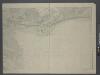