Maps of Saddle Rock Estates

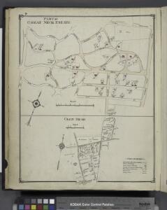
Part of Great Neck Estate; Glen Head
from Atlas of Nassau County, Long Island, N.Y. Complete in one volume. Historical, statistical. Based upon maps on file at the county seat in Mineola and upon private plans and surveys furnished by surveyors and individual owners. Supplemented by careful measurements & field observations by our own corps of engineers.
11B - N.Y. City (Aerial Set).
from Sectional aerial maps of the City of New York / [photographed and assembled under the direction of the chief engineer, July 1st, 1924].
11A - N.Y. City (Aerial Set).
from Sectional aerial maps of the City of New York / [photographed and assembled under the direction of the chief engineer, July 1st, 1924].
Queens, Vol. 3, Double Page Plate No. 15; Part of ward Three Whitestone; [Map bounded by 14th Ave., 11th Ave., Ave. A, Ave. B, Ave. C, Lane, Penn Ave., Willets Point Road, Whitestone Road, Fairview Ave., Plateau Ave., Bay View Ave.; Includ
from Third ward: Flushing.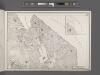
Area District Map Section No. 11
From Area district map
Land use policy (cont.)
From District 11
Bayside, Auburndale, Oakland Gardens, Little Neck, Douglaston. (cont.)
From District 11
Sea Cliff
1 : 24000
Sea Cliff
1 : 24000
Sea Cliff
1 : 24000
Sea Cliff
1 : 24000
Sea Cliff
1 : 24000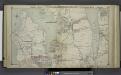
Great Neck - Pt. Washington - Kesington - Sea Cliff - Plandome, Etc.
from Atlas of Nassau County, Long Island, N.Y. Complete in one volume. Historical, statistical. Based upon maps on file at the county seat in Mineola and upon private plans and surveys furnished by surveyors and individual owners. Supplemented by careful measurements & field observations by our own corps of engineers.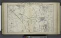
Great Neck Ests. - Manhasset - Roslyn - Mineola, Etc.
from Atlas of Nassau County, Long Island, N.Y. Complete in one volume. Historical, statistical. Based upon maps on file at the county seat in Mineola and upon private plans and surveys furnished by surveyors and individual owners. Supplemented by careful measurements & field observations by our own corps of engineers.
Westchester, Double Page Plate No. 3 [Map of Towns of Westchester and Pelham] / prepared under the direction of Joseph R. Bien, from general surveys and official records.
From Atlas of Westchester County, New York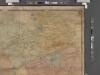
Map of Kings and part of Queens Counties, Long Island, N.Y. / [cartographic material]
From Counties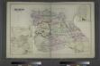
Flushing, Queens Co. L.I. - Douglaston, Town of Flushing, Queens Co. - Hinsdale, Town of Flushing, Kings Co.
from Atlas of Long Island, New York. From recent and actual surveys and records.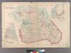
Plate 29: Town of Flushing. - Douglaston. - Bay Side.
from Atlas of Queens Co., Long Island, New York / compiled from official records, private plans & actual surveys by and under the direction of Chester Wolverton.
Index to the Topographical survey sheets of the borough of the Bronx easterly of the Bronx River.
from Topographical survey and new street system of the borough of the Bronx, easterly of the Bronx River
Oyster Bay
1 : 62500
Oyster Bay
1 : 62500
Oyster Bay
1 : 62500
Oyster Bay
1 : 62500
Oyster Bay
1 : 62500
Oyster Bay
1 : 62500
Oyster Bay
1 : 62500
Oyster Bay
1 : 62500
Oyster Bay
1 : 62500
Oyster Bay
1 : 62500
Oyster Bay
1 : 62500
Oyster Bay
1 : 62500
Oyster Bay
1 : 62500
Oyster Bay
1 : 62500
Oyster Bay
1 : 62500
Oyster Bay
1 : 62500