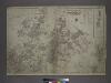
Maps of Inwood
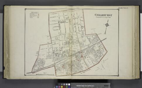
Cedarhurst
from Atlas of Nassau County, Long Island, N.Y. Complete in one volume. Historical, statistical. Based upon maps on file at the county seat in Mineola and upon private plans and surveys furnished by surveyors and individual owners. Supplemented by careful measurements & field observations by our own corps of engineers.
Height District Map Section No. 25; Height district map / City of New York, Board of Estimate and Apportionment.
from Height district map / City of New York, Board of Estimate and Apportionment. New York (N.Y.). Board of Estimate and Apportionment,
Area District Map Section No. 25; Area district map / City of New York, Board of Estimate and Apportionment.
from Area district map / City of New York, Board of Estimate and Apportionment. New York (N.Y.). Board of Estimate and Apportionment,
Use District Map Section No. 25; Use district map / City of New York, Board of Estimate and Apportionment.
from Use district map / City of New York, Board of Estimate and Apportionment. New York (N.Y.). Board of Estimate and Apportionment,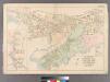
Plate 14: Villages of Woodsburgh, Cedarhurst and Lawrence, Town of Hempstead.
from Atlas of Queens Co., Long Island, New York / compiled from official records, private plans & actual surveys by and under the direction of Chester Wolverton.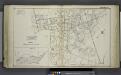
Woodmere (Woodburgh); Sub Plan
from Atlas of Nassau County, Long Island, N.Y. Complete in one volume. Historical, statistical. Based upon maps on file at the county seat in Mineola and upon private plans and surveys furnished by surveyors and individual owners. Supplemented by careful measurements & field observations by our own corps of engineers.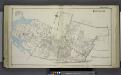
Inwood
from Atlas of Nassau County, Long Island, N.Y. Complete in one volume. Historical, statistical. Based upon maps on file at the county seat in Mineola and upon private plans and surveys furnished by surveyors and individual owners. Supplemented by careful measurements & field observations by our own corps of engineers.
25C - N.Y. City (Aerial Set).
from Sectional aerial maps of the City of New York / [photographed and assembled under the direction of the chief engineer, July 1st, 1924].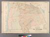
Part of the Village of Far Rockaway.
from Atlas of Queens Co., Long Island, New York / compiled from official records, private plans & actual surveys by and under the direction of Chester Wolverton.
Inwood, Cedarhurst Vicinity
from Atlas of Nassau County, Long Island, N.Y. Complete in one volume. Historical, statistical. Based upon maps on file at the county seat in Mineola and upon private plans and surveys furnished by surveyors and individual owners. Supplemented by careful measurements & field observations by our own corps of engineers.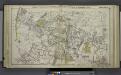
Valley Stream, Lynbrook, Rockville Centre, Woodmere, Etc.
from Atlas of Nassau County, Long Island, N.Y. Complete in one volume. Historical, statistical. Based upon maps on file at the county seat in Mineola and upon private plans and surveys furnished by surveyors and individual owners. Supplemented by careful measurements & field observations by our own corps of engineers.
Key
From Atlas 145a. Vol. 8, 1912.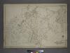
Part of the Borough of Queens, Jamaica, Ward 4.
from Atlas of the city of New York, borough of Queens, Long Island City, Newtown, Flushing, Jamaica, Far Rockaway, from actual surveys and official plans / by George W. and Walter S. Bromley.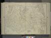
Queens, Vol. 1, Double Page Plate No. 19; Part Of Ward 4; Jamaica; [Map bounded by Conduit Long Island R.R., Boundary Line Of The City of New York; Including Hook Canal Creek, Jamaica Bay, Dead or Salt Creek.]; Sub Plan From Plate No. 17 [Map bou
from Fourth and fifth wards: Jamaica and Rockaway.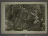
25A - N.Y. City (Aerial Set).
from Sectional aerial maps of the City of New York / [photographed and assembled under the direction of the chief engineer, July 1st, 1924].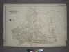
[Plate 44: Bounded by (Banister Creek) Somerset Avenue, (Atlantic Ocean) Jarvis Lane, South Street, Central Avenue, Carleton Avenue, Remsen Avenue, Mc Neil Avenue and Fenwick Avenue.]
from Atlas of the city of New York, borough of Queens, Long Island City, Newtown, Flushing, Jamaica, Far Rockaway, from actual surveys and official plans / by George W. and Walter S. Bromley.
Far Rockaway, Town of Hempstead.
from Atlas of Long Island, New York. From recent and actual surveys and records.
Hewlett Bay Park
from Atlas of Nassau County, Long Island, N.Y. Complete in one volume. Historical, statistical. Based upon maps on file at the county seat in Mineola and upon private plans and surveys furnished by surveyors and individual owners. Supplemented by careful measurements & field observations by our own corps of engineers.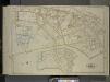
Queens, Vol. 1, Double Page Plate No. 32; Part of Ward 5; Farrockaway; [Map bounded by Central Ave., Crescent Ave., Mc. Neil Ave.; Including Broadway Jarvis Lane, South St.]; Sub Plan; [Map bounded by Jarvis Lane, Oak St.; Including Former Vil
from Fourth and fifth wards: Jamaica and Rockaway.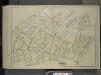
Queens, Vol. 1, Double Page Plate No. 33; Sub Plan No. 1; [Map bounded by Jamaica Bay, Mott Ave.; Including Point Breeze PL., Bay St.]; Sub Plan No. 2; [Map bounded by Batler Ave., Wolcott Ave., Mc. Neil Ave.; Including Central Ave., Seneca St.,
from Fourth and fifth wards: Jamaica and Rockaway.
Jamaica.- Part of Hempstead, Tn. of Hempstead, Queens Co.
from Atlas of Long Island, New York. From recent and actual surveys and records.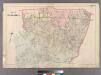
Plate 28: Town of Jamaica.
from Atlas of Queens Co., Long Island, New York / compiled from official records, private plans & actual surveys by and under the direction of Chester Wolverton.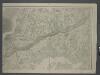
Map of New-York Bay and Harbor and the environs / founded upon a trigonometrical survey under the direction of F. R. Hassler, superintendent of the Survey of the Coast of the United States ; triangulation by James Ferguson and Edmund Blunt, assistants ;
from New York harbor
General map of the city of New York, consisting of boroughs of Manhattan, Brooklyn, Bronx, Queens and Richmond : consolidated into one municipality by act of the legislature of the state of New York (Chapter 378 of the laws of 1897) : showing in addition
from Whole
Map of Queens Borough, City of New York.
From Queens
Index: Borough of Manhattan. Scale 1800 feet to the Inch. LEGEND, [Battery Park - 158th Street].
from Atlas of the city of New York, borough of Manhattan. From actual surveys and official plans / by George W. and Walter S. Bromley.
Hagstrom's Map of Queens, city of New York. House number and subway guide.
From Queens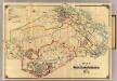
4 White Plains, Harrison, Rye.
1 : 18000 Hyde & Company
Street Indexed map of the Borough of Queens, also showing the Congressional Districts.
From Queens