Maps of Carle Place

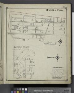
Mineola Park; Hastings Tract
from Atlas of Nassau County, Long Island, N.Y. Complete in one volume. Historical, statistical. Based upon maps on file at the county seat in Mineola and upon private plans and surveys furnished by surveyors and individual owners. Supplemented by careful measurements & field observations by our own corps of engineers.
Westbury - Jericho - Hicksville - Locust - Grove, Etc.
from Atlas of Nassau County, Long Island, N.Y. Complete in one volume. Historical, statistical. Based upon maps on file at the county seat in Mineola and upon private plans and surveys furnished by surveyors and individual owners. Supplemented by careful measurements & field observations by our own corps of engineers.
Floral Park - Mineola - Garden City & Hempstead
from Atlas of Nassau County, Long Island, N.Y. Complete in one volume. Historical, statistical. Based upon maps on file at the county seat in Mineola and upon private plans and surveys furnished by surveyors and individual owners. Supplemented by careful measurements & field observations by our own corps of engineers.
Great Neck Ests. - Manhasset - Roslyn - Mineola, Etc.
from Atlas of Nassau County, Long Island, N.Y. Complete in one volume. Historical, statistical. Based upon maps on file at the county seat in Mineola and upon private plans and surveys furnished by surveyors and individual owners. Supplemented by careful measurements & field observations by our own corps of engineers.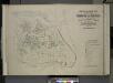
Index map to Vol. 3; Atlas of the Borough of Queens Third Ward city of New York. Published by E. Belcher Hyde; 97 Liberty St., Brooklyn Borough. 1904.
from Third ward: Flushing.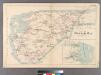
Plate 32: Town of Oyster Bay.
from Atlas of Queens Co., Long Island, New York / compiled from official records, private plans & actual surveys by and under the direction of Chester Wolverton.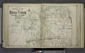
Upper section Index Map of Nassau County Long Island Published by E. Belcher Hype. 97 Liberty St. Brooklyn, 5 Beekman St. Manhattan. 1914.
from Atlas of Nassau County, Long Island, N.Y. Complete in one volume. Historical, statistical. Based upon maps on file at the county seat in Mineola and upon private plans and surveys furnished by surveyors and individual owners. Supplemented by careful measurements & field observations by our own corps of engineers.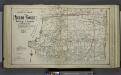
Lower section Index Map of Nassau County Long Island Published by E. Belcher Hype. 97 Liberty St. Brooklyn, 5 Beekman St. Manhattan. 1914.
from Atlas of Nassau County, Long Island, N.Y. Complete in one volume. Historical, statistical. Based upon maps on file at the county seat in Mineola and upon private plans and surveys furnished by surveyors and individual owners. Supplemented by careful measurements & field observations by our own corps of engineers.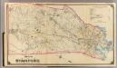
9 Stamford.
1 : 18000 Hyde & Company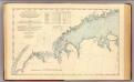
N.Y.-Norwalk Is.
1 : 80000 United States Coast Survey
Birds Eye View Map Of New York And Vicinity.
1 : 80033 Hammond, C.S.
Topographical map of New York City, County and vicinity: showing old farm lines &c. / based on Randells and other official surveys, drawings and modern surveys by J.F. Harrison & T. Magrane; printed by C. Wadlow.
from (A-Z) J. F. Harrison; T. Magrane; C. Wadlow,
Topographical map of New York City, County and vicinity: showing old farm lines &c. / based on Randells and other official surveys, drawings and modern surveys by J.F. Harrison & T. Magrane; printed by C. Wadlow.
from (A-Z) J. F. Harrison; T. Magrane; C. Wadlow,
Panorama of the Borough of the Bronx issued by the Bronx Home News.
From Bronx
Greater New York's census districts, 1920 : compiled from map prepared 1915-1918 for the 1920 census by the New York Federation of Churches.
From Manhattan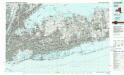
Long Island West
1 : 100000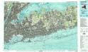
Long Island West
1 : 100000
[A chart of New York Island & North River, East River, passage through Hell Gate, Flushing Bay, Hampstead Bay, Oyster Bay, Huntington Bay, Cow Harbour, East Chester Inlet, Rochelle, Rye, Patrick Islands, &c.]
from Charts and maps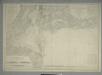
Map of New-York Bay and Harbor and the environs : [with colored manuscript additions to show positions of troops and fleets at the Battle of Long Island, 1776] / founded upon a trigonometrical survey under the direction of F.R. Hassler, superintendent of
from New York harbor
Map of enlarged city of Brooklyn, from official records and surveys.
From Brooklyn
Mass Transit program New York City
From The Borough
United States--east coast, New York--New Jersey, New York Harbor / Coast Survey.
United States Coast Survey,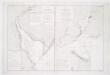
Carte de la baye et riviere de Délaware: contenant une éxacte et entiére description des rivages, criques, havres, sondes, bas-sonds, sables et les gissements des marques les plus considérables du pays depuis les Caps James et May jusqu̕à Philadelphie, suivant la carte originale, publiée en cette ville / par Josué Fischer; Depot de la marine.
from Charts and maps Josué Fischer,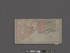
Map of New York City showing portions of Brooklyn, Jersey City, and Westchester Co.
From Manhattan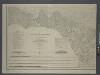
Map of New-York Bay and Harbor and the environs / founded upon a trigonometrical survey under the direction of F. R. Hassler, superintendent of the Survey of the Coast of the United States; triangulation by James Ferguson and Edmund Blunt, assistants; the hydrography under the direction of Thomas R. Gedney, lieutenant U.S. Navy; the topography by C. Renard and T.A. Jenkins assists.
from New York harbor Ferdinand R. Hassler; James Ferguson; Thomas R. Gedney; C. Renard; T.A. Jenkins,
Map of New-York Bay and Harbor and the environs / founded upon a trigonometrical survey under the direction of F.R. Hassler, superintendent of the Survey of the Coast of the United States; triangulation by James Ferguson and Edmund Blunt assistants; the hydrography under the direction of Thomas R. Gedney, lieutenant U.S. Navy; the topography by C. Renard and T.A. Jenkins assists.; verified by C.M. Eakin, assistant.
from New York harbor Ferdinand R. Hassler; James Ferguson; Thomas R. Gedney; C. Renard; T.A. Jenkins; C.M. Eakin,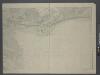