Maps of Europe
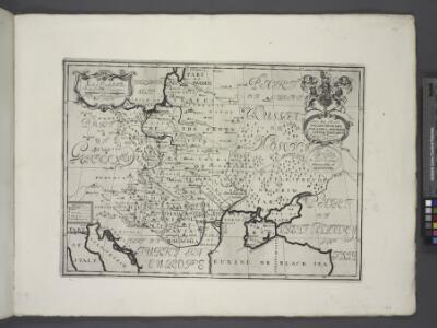
Hungary, Transylvania, Poland, &c.
from A new sett of maps both of antient and present geography : wherein not only the latitude and longitude of many places are corrected according to the latest observations, but also the most remarkable differences of antient and present geography may be quickly discern'd by a bare inspection or comparing of correspondent maps, which seems to be the most natural and easy method to lead young students (for whose use the work is principally intended) unto a competent knowledge of the geographical science : together with a geographical treatise particularly adapted to the use and design of these maps / by Edward Wells, M.A. and student of Christ-Church, Oxon.
Europa mit Berücksichtigung der Veränderungen von 1815 - 1870
Europa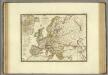
Europe en 1813.
1 : 12400000 Brue, Adrien Hubert, 1786-1832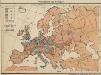
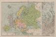
Volksdichte von Europa
1 : 30000000 Europa Bevölkerungsdichte
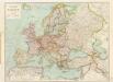
Politische Karte von Europa
1 : 20000000 Europa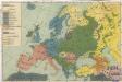
Sprachenkarte von Evropa

Europa, Fluss- und Gebirgskarte
1 : 24000000 Europa Physische Geografie
Europa beim Beginn der französischen Revolution. 1789
Europa Französische Revolution
Europa im Jahr 1812
Europa
Völkerkarte von Europa
1 : 23500000 Europa Ethnische Gruppe
Map of Europe, Showing its Gt. Political Divisions
1 : 20000000 Mitchell, Samuel Augustus Jr.
Oro-Hydrographische Charte von Europa
Europa Orohydrografie
Europa während des Zeitraums der Reformation und der Übermacht des Hauses Habsburg 1492 - 1618
1 : 15000000 Europa
Bevölkerungsdichtigkeit von Europa
1 : 23500000 Europa Bevölkerungsdichte
Charte von Europa
Europa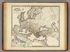
Imperium Romanorum inde a Constantini Magni tempore.
1 : 15500000 Menke, Th.
Religionskarte von Europa
1 : 23500000 Europa Denomination
Europa zur Zeit Carls V. 1526
Europa Karl V., Heiliges Römisches Reich, Kaiser
Karte von Europa
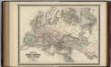
Roman Empire at the Time of Christ.
1 : 12300000 Johnson, A.J.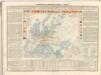
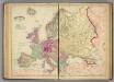
Europe.
1 : 10200000 Higgins & Ryan
Europa
Volksschul-Atlas über alle Teile der Erde Lange, Henry Druck und Verlag von Georg Westermann
[Recto], uit: Europa / [aardrijkskundig medew. G.J. de Vries]
1 : 25000000 titelvariant: Landen van Europa met de hoofdsteden; Annotatie: Titel boven de krt.: Landen van Europa met de hoofdsteden; Verso: register van landen met de hoofdsteden Gerben Johannes de Vries 1886-1968 Sneek : Tonnema & Cie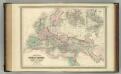
Roman Empire at the Time of Christ.
1 : 12300000 Johnson, A.J.
Roman Empire at the Time of Christ.
1 : 12300000 Johnson, A.J.
Carte d'Europe dressée pour l'usage du Roy sur les itineraires anciens et modernes et sur les routiers de mer assujetis aux observations astronomiques
1 : 570000 par G. Delisle, premier geographe de S.M. de l'Academie Royale des Sciences J. Condet f[ecit] À Amsterdam : chez J. Cóvens et C. Mortier
Politický přehled Evropy