Maps of Metropolitan France
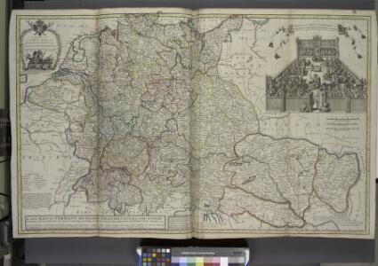
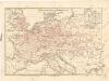
A new map of Germany, Hungary, Transilvania & the Suisse cantons, ...
from The world described, or, A new and correct sett of maps : shewing the kingdoms and states in all the known parts of the earth, with the principal cities, and most considerable towns in the world ... / ... by Herman Moll, geographer ...
2. Pyrenäenfriede 1659
1 : 30000000 Mitteleuropa Pyrenäenfriede
Eisenbahn-Übersichtskarte von Mittel-Europa
Evropa R. v. Waldheim
Eisenbahn-Übersichtskarte von Mittel-Europa
Evropa R. v. Waldheim
Eisenbahn-Übersichtskarte von Mittel-Europa
Evropa
Eisenbahn-Übersichtskarte von Mittel-Europa
Evropa R. v. Waldheim
Izvoz robe i vrijednost produkcije većih tvornica 1912. Kralj. Hrvatska i Slavonija
Kroatien Slawonien Export Statistik Industrie
Übersichtskarte des Eisenbahn- und Telegraphen-Verbindungen von Mittel-Europa
1 : 6170000 Evropa střední Mayer, Alexander
Post roads Germany, Hungary.
1 : 2500000 Robert Laurie & James Whittle
Eisenbahnkarte von Mittel Europa
1 : 3375000 Berlín (Německo) Broditzky, Joseph R. v. Waldheim
Eisenbahnkarte von Mittel Europa
1 : 3375000 Berlín (Německo) Broditzky, Joseph R. v. Waldheim
Eisenbahnkarte von Mittel Europa
1 : 3375000 Berlín (Německo) Broditzky, Joseph R. v. Waldheim
Eisenbahnkarte von Mittel Europa
1 : 3375000 Berlín (Německo) Broditzky, Joseph R. v. Waldheim
Eisenbahnkarte von Mittel Europa
1 : 3375000 Berlín (Německo) Broditzky, Joseph R. v. Waldheim
Sbírka map a diagramů použitých na mírových konferencích v Paříži v letech 1919 - 1920

Karte der Heilquellen und Kurorte von Mittel - Europa
Eisenbahnkarte von Mitteleuropa

Mitteleuropa
1 : 8000000 Evropa střední Kocen, Blaž Eduard Hölzel
Eisenbahn und Telegraphen-Karte von Europa
Evropa Kastner, Leopold Hacker, Ant. Mechitharisten-Buchdruckerei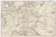
Eisenbahn und Telegraphen-Karte von Europa
Evropa Kastner, Leopold Hacker, A.
Volksdichtekarte von Mitteleuropa
1 : 9000000 Mitteleuropa Bevölkerungsdichte
Eisenbahn-Übersichtskarte von Mittel-Europa
Evropa R. v. Waldheim
[Historisch-geographischer Atlas zu den allgemeinen Geschichtswerken von C. v. Rotteck, Pölitz u. Becker] : Gallien, Britannien, Germanien und die obern Donau-Länder nach Cæsar, Tacitus, Ptolemæus, Plinius, etc.
von Joh. Val. Kutscheit Lithographie der Herderschen Verlags-Handlung zu Freiburg im Breisg. [Freiburg im Breisgau] : [Herder]
Střední Evropa v době náboženské reformace a protireformace 1517 - 1648

[Historisch-geographischer Atlas zu den allgemeinen Geschichtswerken von C. v. Rotteck, Pölitz u. Becker] : Napoleon's Kaiserreich mit Angabe der Hauptbegebenheiten und der Vergrösserungen Frankreichs
von Julius Loewenberg Lithographie v. B. Herder in Freiburg im Breisgau [Freiburg im Breisgau] : [Herder]
Central-Europa
Mitteleuropa
Völkerkarte von Mitteleuropa
1 : 9000000 Mitteleuropa Ethnische Gruppe
Říše Karla Velikého

Deutschland, Niederlande, Belgien und Schweiz
Schul-Atlas über alle Theile der Erde nach dem neuesten Zustande, und über das Weltgebäude Stieler, Adolf Justus Perthes