Maps of Georgia
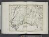
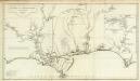
Luigiana Inglese, colla parte Occidentale, della Florida, della Georgia, e Carolina Merid[i]onale.
from Le colonie unite dell' America settentrle : di nuova projezione a s.s.e.e. li Signori Riformatori dello Studio di Padova.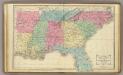
Southern U.S.
1 : 3500000 Cornell, S. S. (Sarah S.)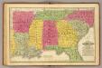
Southern States.
1 : 3700000 Mitchell, Samuel Augustus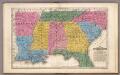
Map of the Southern States.
1 : 3700000 Mitchell, Samuel Augustus
Mississippi Territory.
from Carey's general atlas, improved and enlarged : being a collection of maps of the world and quarters, their principal empires, kingdoms, &c.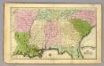
Southern States.
1 : 3500000 Olney, J. (Jesse), 1798-1872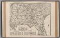
South Carolina. Florida. Georgia. Mississippi. Alabama. North Carolina. South Carolina.
1 : 1165000 Rand McNally and Company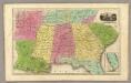
Southern States. (with) South Part of Florida.
1 : 3450000 Smiley, Thomas T.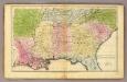
Southern States.
1 : 3600000 Huntington, Francis Junius, 1802-1878
County map of Georgia and Alabama.
from New general atlas.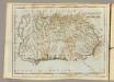
Georgia.
1 : 6000000 Carey, Mathew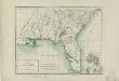
Carte de la Floride et de la Georgie
1 : 3500000 Tardieu, P. F. (Pierre François), 1757-1822 P.G. Chanlaire et E. Mentelle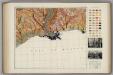
Soil Map of the United States, Section 10. Atlas of American Agriculture.
1 : 2500000 Marbut, Curtis F.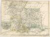
Die Staaten von Arkansas, Mississippi, Louisiana und Alabama
Carte de la Louisiane.
1 : 830000 Anville, Jean Baptiste Bourguignon d, 1697-1782
Map of Louisiana, Mississippi, and Arkansas.
from New general atlas.
Georgia.
1 : 6336000 Scott, Joseph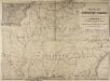
Railway Map of the Southern States, showing the Railway Lines, their Stations and intermediate distances between Louisville and the Gulf of Mexico and Southern Atlantic Coast, etc. Scale of miles, 20 to one inch.
Railway Map of the Southern States, showing the Railway Lines, their Stations and intermediate distances between Louisville and the Gulf of Mexico and Southern Atlantic Coast, etc.
Georgia, Alabama, and Florida.
1 : 3623775 Fisher, Richard Swainson
Alabama, Georgia, Sud Carolina und Florida.
1 : 3400000 Lange, Henry, 1821-1893.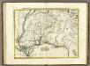
Luigiana Inglese, colla Parte Occidentale della Florida, della Giorgia, e Carolina Meridonale.
1 : 2100000 Zatta, Antonio
Louisiana, Mississippi, Alabama.
1 : 1808000 Finley, Anthony
Georgia.
1 : 6500000 Henshaw, Frances A.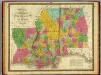
Map of Louisiana, Mississippi and Alabama.
1 : 1700000 Mitchell, Samuel Augustus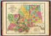
Map of Louisiana Mississippi And Alabama.
1 : 1750000 Finley, Anthony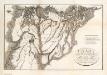
Chart Of The Sources Of The Mobile.
Tardieu, P.F.
Georgia.
1 : 2914560 Carey, Mathew
Georgia.
1 : 977920 Carey, Mathew
Georgia.
1 : 3000000 Lewis, Samuel
![Luigiana Inglese, colla parte Occidentale, della Florida, della Georgia, e Carolina Merid[i]onale.](https://images-2.georeferencer.com/images/iiif/980728668188/full/,300/0/native.jpg)

