Maps of Kings County
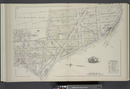
Vol. 5. Plate, G. [Map bound by Washington Park, Portland Ave., Atlantic Ave., Fourth Ave., Flatbush Ave., Fulton St., Fleet St., Fleet Pl., Bolivar St.; Including Elliot Place, Canton St., Fort Greene Place, St. Felix St., Raymond St., Navy St., Hudson
from Detailed estate and old farm line atlas of the city of Brooklyn : complete in six volumes ... from official records, private plans, and actual surveys ... / by G.M. Hopkins, C.E.
Brooklyn, Vol. 2, Double Page Plate No. 2; Part of Wards 11 & 20, Section 7; [Map bounded by Dekalb Ave., Southoxford St., Atlantic Ave.; Including Flatbush Ave., Fulton St.]; Plan of United States Navy Yard and Wall About Basin. [Map bounded by E
from Wards 7, 11, 20, 21, 23, 24 & 25.
Map of part of the Jackson Homestead in the 7th ward of the city of Brooklyn : belonging to Christiana A. Jackson (now Mrs. Peters) to be sold at auction by James Cole, auctr., on Monday 19th Novr. 1849 at 12 o'clock at the Merchants' Exchange, N.Y.
from Brooklyn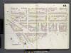
Brooklyn V. 2, Double Page Plate No. 44 [Map bounded by State St., Hoyt St., De Kalb Ave., Navy St., 3rd Ave.]
From Atlas 66. Vol. 2, 1887.
Plate 26: Map bounded by Schermerhorn Street, Powers Street, Fulton Avenue, Lafayette Street, Raymond Street, 4th Avenue, Wyckoff Street, Hoyt Street.
from Maps of the city of Brooklyn
[Plate 25: Map bounded by Willoughby Street, Raymond Street, Lafayette Avenue, Flatbush Avenue, Powers Street, Schermerhorn Street, Bond Street, Fulton Avenue, Gold Street]
from Maps of the city of Brooklyn
[Plate 24: Map bounded by Myrtle Avenue, Cumberland Street, Lafayette Avenue, Raymond Street]
from Maps of the city of Brooklyn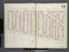
Brooklyn V. 2, Double Page Plate No. 49 [Map bounded by Lafayette Ave., Navy St., De Kalb Ave., Carlton Ave.]
From Atlas 66. Vol. 2, 1887.
[Plate 23: Map bounded by Lafayette Avenue, Cumberland Street, Atlantic Avenue, 4th Avenue, Raymond Street]
from Maps of the city of Brooklyn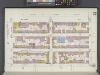
Brooklyn V. 2, Plate No. 23 [Map bounded by Atlantic Ave., Hoyt St., Livingston St., Nevins St.]
From Atlas 67. Vol. 2, 1904.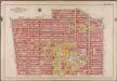
Plate 4: [Bounded by Atlantic Avenue, Bond Street, Schermerhorn Street, Flatbush Avenue, Fifth Avenue, President Street and Court Street.]; Atlas of the borough of Brooklyn, city of New York: from actual surveys and official plans by George W. and Walter S. Bromley.
from Atlas of the borough of Brooklyn, city of New York : from actual surveys and official plans by George W. and Walter S. Bromley. G.W. Bromley & Co.,
[Plate 5: Bounded by Clermont Avenue, Greene Avenue, Hanson Place, S. Portland Avenue, Atlantic Avenue, Flatbush Avenue, Schermerhorn Street, Bond Street, Fulton Street, Gold Street, Tillary Street, Navy Street, and Flushing Avenue.]
from Atlas of the city of Brooklyn, New York.
Double Page Plate No. 27: [Bounded by Willoughby Avenue, Steuben Street, Lafayette Avenue, Grand Avenue, Atlantic Ave (Jamaica Turnpike), Flatbush Avenue, Fulton Street, (Fort Green) Dekalb Avenue and Washington Park.
from Atlas of the Brooklyn borough of the City of New York : originally Kings Co.; complete in three volumes ... based upon official maps and plans ... / by and under the supervision of Hugo Ullitz, C.E.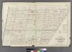
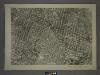
Plate 6: Part of Wards 11 & 20 City of Brooklyn.
from Atlas of the entire city of Brooklyn, complete in one volume. From actual surveys and official records by G. W. Bromley & Co.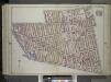
Brooklyn, Vol. 1, Double Page Plate No. 27; Part of Wards 7-11, 20 Section 7; [Map bounded by Willoughby Ave., Steuben St., Lafayette Ave., Grand Ave., Atlantic Ave.; Including Flatbush Ave., Fulton St., Hudson Ave., De Kalb Ave., Washington Park] / b...
From Volume 1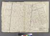
Plate 4: Part of Wards 3, 4, 10, & 11. City of Brooklyn.
from Atlas of the entire city of Brooklyn, complete in one volume. From actual surveys and official records by G. W. Bromley & Co.
Vol. 5. Plate, J. [Map bound by Bond St., Fulton St., Flatbush Ave., Fourth Ave., Butler St.; Including Nevins St., Hanover Pl., Third Ave., Baltic St., Warren St., Wyckoff St., Bergen St., Dean St., Pacific St., Atlantic Ave., State St., Schermerhorn St
from Detailed estate and old farm line atlas of the city of Brooklyn : complete in six volumes ... from official records, private plans, and actual surveys ... / by G.M. Hopkins, C.E.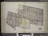
Brooklyn, Vol. 1, Double Page Plate No. 28; Part of Wards 11 & 20, Section 7; Map bounded by Flushing Ave., Washington Ave., Willoughby Ave., Washington Park; Including De Kalb Ave., Hudson Ave., Fulton St., Johnson St., Navy St. / by and under the di...
From Volume 1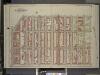
Brooklyn, Vol. 1, Double Page Plate No. 14; Part of Wards 3 & 10, Section 1 & 2; [Map bounded by 3rd Ave., Douglass St., Hoyt St.; Including Fulton St., Flatbush Ave.]
from Wards 1, 2, 3, 4, 5, 6, 8, 9, 10, 12 & 22.
Part of Wards 11 & 20. Land Map Section, No. 7, Volume 1, Brooklyn Borough, New York City.
from Atlas of the Brooklyn borough of the City of New York : originally Kings Co.; complete in three volumes ... based upon official maps and plans ... / by and under the supervision of Hugo Ullitz, C.E.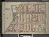
Brooklyn, Vol. 1, Double page Plate No. 15; Part of Wards 3, 9 & 10, Section 1, 2 & 4; [Map bounded by 6th Ave., Berkeley PL., Sackett St.; Including 3rd Ave., Flatbush Ave, Atlantic Ave.]
from Wards 1, 2, 3, 4, 5, 6, 8, 9, 10, 12 & 22.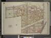
Brooklyn, Vol. 2, Double Page Plate No. 1; Part of Ward 11, Section 7; [Map bounded by North Elliott PL., St. Edwards St., Raymond St., Dekalb Ave.; Including Fulton St., Bridge St., Johnson St., Navy St., Flushing Ave.]
from Wards 7, 11, 20, 21, 23, 24 & 25.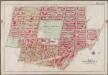
Plate 5: [Bounded by Clermont Avenue, Greene Avenue, S. Portland Avenue, Atlantic Avenue, Fourth Avenue, Flatbush Avenue, Schermerhorn Street, Bond Street, Dekalb Avenue, Gold Street, Tillary Street, Navy Street & Flushing Avenue]; Atlas of the borough of Brooklyn, city of New York: from actual surveys and official plans by George W. and Walter S. Bromley.
from Atlas of the borough of Brooklyn, city of New York : from actual surveys and official plans by George W. and Walter S. Bromley. G.W. Bromley & Co.,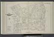
Vol. 5. Plate, F. [Map bound by Johnson St., Pearl St., Myrtle Ave., Fleet Place, Fleet St., Bond St., State St., Boerum St., Atlantic Ave., Court St., Fulton St.; Including Fair St., Willoughby St., Livingston St., Schermerhorn St., Washington St., Adam
from Detailed estate and old farm line atlas of the city of Brooklyn : complete in six volumes ... from official records, private plans, and actual surveys ... / by G.M. Hopkins, C.E.
Brooklyn, Vol. 2, Double Page Plate No. 4; Part of Wards 20 & 11, Section 7; [Map bounded by Waverly Ave., De Kalb Ave.; Including North Elliott PL., Flushing Ave.]
from Wards 7, 11, 20, 21, 23, 24 & 25.
[Plate 27: Map bounded by Schermerhorn Street, Nevins Street, Warren Street, Hoyt Street]
from Maps of the city of Brooklyn
[Plate 28: Map bounded by Willoughby Street, Gold Street, Fulton Avenue, Bond Street, Schermerhorn Street, Hoyt Street, Jay Street]
from Maps of the city of Brooklyn
[Plate 19: Map bounded by Concord Street, Navy Street, Park Avenue, Raymond Street, Willoughby Street, Duffield Street]
from Maps of the city of Brooklyn
[Plate 20: Map bounded by Flushing Avenue, Cumberland Street, Myrtle Avenue, Raymond Street, Park Avenue, Navy Street]
from Maps of the city of Brooklyn