Maps of Rocky Mountains
Paskaerte van Nova Granada en t'Eylandt California.
from De zee-atlas ofte water-wereld : waer in vertoont werden alle de zee-kusten van het bekende des aerd-bodems : seer dienstigh voor alle heeren en kooplieden, als oock voor alle schippers en stuurlieden / by Pieter Goos.
Amerique Septentrionale 3.
1 : 7500000 Brue, Adrien Hubert, 1786-1832
Carte De La Cote De L'Amerique.
1 : 5555555 Duflot de Mofras, Eugene
North America, 1782.
1 : 28000000 Jefferys, Thomas
The United States & the relative position of the Oregon & Texas / by James Wyld, Charing Cross East.
from Whole
Central America and Yucatan (Mexico).
from The cerographic atlas of the United States. By Sidney E. Morse, A.M., and Samuel Breese, A.M.
Facsimile: Walch's North America (portion).
1 : 13000000 Walch, Joh.
Vereinigte Staaten
1 : 18500000 Severní Amerika Biller, Franz
Louisiana.
1 : 23500000 Carey, Mathew
Composite: Map of Louisiana and Mexico.
1 : 4300000 Tardieu, P.F.
Gray's Geological Map of the United States
from New illustrated atlas of Dutchess County, New York. / Compiled & drawn from personal examinations, surveys etc. under the personal supervision of O.W. Gray & Son and F.A. Davis, and published under the superintendence of H. L. Kochersperger.
Vereinigten Staaten von Nordamerika, West-Hälfte
Geographischer Atlas über alle Theile der Erde Ziegler, Jakob Melchior Verlag von Joh. Wurster um Comp.
A New Map of Texas Oregon and California With The Regions Adjoining.
1 : 6652800 Mitchell, Samuel Augustus
Vereinigte Staaten von NordAmer(ika, nebst Mexico und Centralamerika, West)
1 : 7000000 Stein, Christ. Gottfr. Dan.
United States

Carte Generale du Mexique et des Provinces-unis de l'Amerique Centrale.
1 : 15500000 Vivien de St Martin, L.
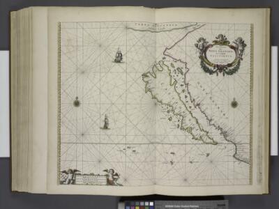
De kusten van Nova Granada en 't eijland California zijnde de noordelijkste zeekusten in de Zuijt Zee int groot
Mexico Gerard van Keulen
Composite: (U.S. West) Railroad Map of the United States.
1 : 1140480 Rand McNally and Company
United States

Westliches-Nordamerica
Neuer Handatlas über alle Theile der Erde Kiepert, Heinrich Verlag von Dietrich Reimer
Ornamental Map Of The United States & Mexico.
1 : 13000000 Ensigns & Thayer
A New Map of Texas Oregon and California With The Regions Adjoining.
1 : 6652800 Mitchell, Samuel Augustus
Maris Pacifici, America.
Schoner, Johann
A New Map of Texas Oregon and California With The Regions Adjoining.
1 : 6652800 Mitchell, Samuel Augustus
A New Map of The States Of Texas & California
1 : 6652800 Mitchell, Samuel Augustus
Mexico and Adjacent Provinces.
1 : 2450000 Humboldt, Alexander von, 1769-1859
Shell Highway Map of Western United States.
1 : 4752000 Shell Oil Company
Colton's Map of the Pacific States California & Oregon with the territories of Nevada, Utah, New Mexico, Colorado & Washington in connection with British Columbia, etc.
Colton's Map of the Pacific States California and Oregon, etc. Although the majority of the American Civil War took place east of the Mississippi River, the West played its own part in the conflict. Territorial expansion westwards and the issue of whether slavery would be established in new regions was one of the main causes for fierce debate in the decades leading up to the Civil War. The map, Colton’s Map of the Pacific States of California and Oregon, published by Colton in 1862, not only details the Pacific Coast, but the territories of Nevada, Utah, New Mexico, Colorado and Washington, as well as a portion of British Columbia. California, which gained statehood in 1850, contains many settlements and detail that is striking by comparison to the near empty territories eastwards. Union troops were positioned on this side of the country, mostly to defend communication routes and railway lines from Confederate sabotage, as well as occasional skirmishes with indigenous Native American tribes. There are several little notes on the map that highlight this was intended not just for general interest but for potential settlers. For example, in Utah Territory, already settled in parts by Mormons, ‘low rolling hills and fine pastorage for cattle’ is described, one of several comments about how fertile the land would be for agricultural development. An ‘emigrant road’ is marked, along with the names of Native American tribes across the map, and in Arizona, the map mentions that ‘silver is found in this region’. This map demonstrates that America’s expansion was not going to be stopped by events in the eastern half of the country.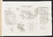
[Ergänzungen und Berichtigungen]
Geographischer Atlas über alle Theile der Erde Ziegler, Jakob Melchior Verlag von Dietrich Reimer