Maps of United States
Map of The United States, and Territories. Together with Canada & c. ; Island of Newfoundland
from Atlas of Schuyler County, New York : from actual surveys by and under the direction of Beach Nichols.
Map of The United States
from Atlas of Wayne County, New York : from actual surveys and official records / compiled & published by D. G. Beers & Co.
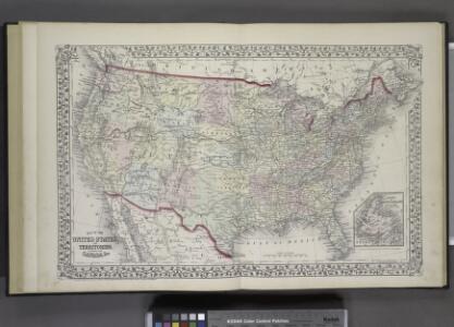
Map of The United States of America
from Atlas of Steuben County, New York : from actual surveys and official records / compiled & published by D.G. Beers & Co.
Charte von Nordamerica
1 Karte : Kupferdruck ; 57 x 50 cm Reichard im Verlage des Industrie Comptoirs
Standard American Map.
1 : 3168000 Monk, Jacob
地理志略:北亞美麗加
地理志略 1903年,Alice S. Parker 此为用厦门闽南方言表述、罗马拼音书写的世界地理介绍性著作,介绍了清朝地理和世界六大洲地理概况。内有《大清國》图和《十八省》图,分别为全清和内地省级行政区划图。 2图,彩色,厦门方言罗马拼音,19.8 x 22.8 cm Harvard-Yenching | Rare Book | TA 2380 68.1,Hollis Number:008161909
America, about 1670.
1 : 65000000 Wit, Frederik de
Continental Map Of North America.
1 : 3041280 Monk, Jacob
A map of North America: with the European settlements & whatever else is remarkable in ye West Indies, from the latest and best observations / R.W. Seale, delin. et sculp.
from Whole R.W. Seale,
An accurate map of the British, French & Spanish settlements in Nth. America and the West Indies: as stipulated by the preliminary articles of peace sign'd at Fontainebleau by the ministers of Great Britain, France & Spain, Novr. 3d, 1762. / J. Gibson sculp.
from Whole Payne, John; Gibson, John,
Nord-America
Hand-Atlas über alle Theile der Erde und über das Weltgebäude Stieler, Adolf Justus Perthes
Sewerní Amerika.

Charte von Nord-America
1 : 20500000 Severní Amerika
CHARTE von NORD-AMERICA
1 : 20500000 Severní Amerika
North America.
1 : 33000000 Worcester, J. E.
Special -Karte der Vereinigten Staaten von Nord - America No 16.

North America.
1 : 36000000 Darton, William
The United States & the relative position of the Oregon & Texas / by James Wyld, Charing Cross East.
from Whole
Nordamerica
Neuester Schul-Atlas Walch, Johann im Verlag bei Joh. Walch
Map of the United States of America, the British provinces, Mexico, the West Indies and Central America, with part of New Granada and Venezuela / map drawn by Geo. W. Colton ; engraved by John M. Atwood ; border desig'd. & eng'd. by W. S. Barnard.
from Parts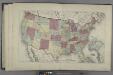
Map of the United States
from Atlas of Madison County, New York : from actual surveys / by and under the direction of D. G. Beers.
Soubor němých map pro gymnasia a odborné školy

Map Of The United States The British Provinces Mexico &c.
1 : 14000000 Colton, J. H.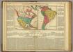
America.
1 : 30200000 Lea, I.
Oceanie 2.
1 : 15500000 Brue, Adrien Hubert, 1786-1832
United States, Mexico, Central America, Caribbean.
1 : 1584000 Smith, J. Calvin
A map of North America with the European settlements & whatever else is remarkable in ye West Indies from the latest and best observations / R.W. Seale delin. et sculp.
from Whole R.W. Seale,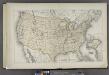
Map of the United States
from County atlas of Cayuga, New York. From recent and actual surveys and records under the superintendence of F. W. Beers.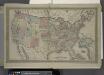
Map of The United States
from Atlas of Franklin County, New York. : From actual surveys and official records.