Maps of Saratoga Springs
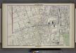
Saratoga Springs [cont.]
from Illustrated combination atlas of Saratoga and Ballston.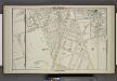
Saratoga Springs [cont.]
from Illustrated combination atlas of Saratoga and Ballston.
References. ; Saratoga Springs [Village]; Saratoga Springs Business Directory.
from New topographical atlas of Saratoga Co., New York, from actual surveys by S. N. & D. G. Beers and assistants.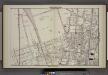
Saratoga Springs [cont.]
from Illustrated combination atlas of Saratoga and Ballston.
Saratoga Springs, Saratoga County, New York.
1 : 42240 Beers, B.G.
Saratoga Springs
1 : 24000
Saratoga Springs
1 : 24000
Saratoga Springs
1 : 24000
Saratoga Springs [Township]
from New topographical atlas of Saratoga Co., New York, from actual surveys by S. N. & D. G. Beers and assistants.
Greenfield [Township]; Pages Corners Business Directory.
from New topographical atlas of Saratoga Co., New York, from actual surveys by S. N. & D. G. Beers and assistants.
Saratoga
1 : 62500
Saratoga
1 : 62500
Saratoga
1 : 62500
Saratoga
1 : 62500
Saratoga
1 : 62500
Saratoga
1 : 62500
Saratoga
1 : 62500
Saratoga
1 : 62500
Saratoga
1 : 62500
Saratoga
1 : 62500
Saratoga
1 : 62500
Saratoga
1 : 62500
Saratoga
1 : 62500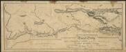
Map and profile of the Champlain Canal as made from Lake Champlain to the Hudson River and surveyed thence to the tide at Waterford
1 : 190080 Geddes, James
Saratoga County.
1 : 151000 Burr, David H., 1803-1875
Map of Schenectady County
from New topographical atlas of the counties of Albany and Schenectady, New York : from actual surveys / by S.N. & D.G. Beers and assistants.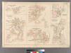
Plate 16: Greenwich Point, Town of Hempstead, Hewetts, Town of Hempstead, Seaford, Town of Hempstead, Pearsalls, Town of Hempstead, Valley Stream, Town of Hempstead and Baldwins, Town of Hempstead.
from Atlas of Queens Co., Long Island, New York / compiled from official records, private plans & actual surveys by and under the direction of Chester Wolverton.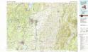
Glens Falls
1 : 100000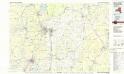
Glens Falls
1 : 100000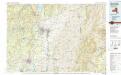
![Saratoga Springs [cont.]](https://images-2.georeferencer.com/images/iiif/054205764962/full/,300/0/native.jpg)

