Maps of Beacon

Fishkill on the Hudson [Village]
from New illustrated atlas of Dutchess County, New York. / Compiled & drawn from personal examinations, surveys etc. under the personal supervision of O.W. Gray & Son and F.A. Davis, and published under the superintendence of H. L. Kochersperger.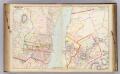
15 Orange, Dutchess counties.
1 : 14400 Watson & Co. (New York, N.Y.)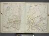
Portion of Orange County. ; Portion of Dutchess County.
from Atlas of the Hudson River Valley from New York city to Troy, including a section of about 8 miles in width. Published by Watson & co. Compiled from official records and careful surveys, under the supervision of F. W. Beers.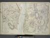
Plan of Cornwall Orange County. Spread E-W
from Atlas of the Hudson River Valley from New York city to Troy, including a section of about 8 miles in width. Published by Watson & co. Compiled from official records and careful surveys, under the supervision of F. W. Beers.
West Point
1 : 24000
West Point
1 : 24000
West Point
1 : 24000
West Point
1 : 24000
West Point
1 : 24000
West Point
1 : 24000
Portion of Orange County. ; Portion of Dutchess & Putnam County.
from Atlas of the Hudson River Valley from New York city to Troy, including a section of about 8 miles in width. Published by Watson & co. Compiled from official records and careful surveys, under the supervision of F. W. Beers.
Wappingers Falls
1 : 24000
Wappingers Falls
1 : 24000
Wappingers Falls
1 : 24000
Wappinger Falls
1 : 24000
Wappinger Falls
1 : 24000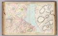
14 Orange, Dutchess, Putnam counties.
1 : 14400 Watson & Co. (New York, N.Y.)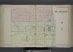
City of Newburgh N.Y. [Village]
from County atlas of Orange, New York / from actual surveys by and under the direction of F.W. Beers.
Shultzville [Village]; South Amenia [Village]; La Fayetteville [Villahe]; Fishkill [Township]; Jacksons Corners [Village]
from New illustrated atlas of Dutchess County, New York. / Compiled & drawn from personal examinations, surveys etc. under the personal supervision of O.W. Gray & Son and F.A. Davis, and published under the superintendence of H. L. Kochersperger.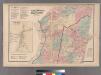
Large folder - L1
from Atlas of New York and vicinity : from actual surveys / by and under the direction of F. W. Beers, assisted by A. B. Prindle & others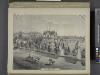
Residence of Edwin Parmelee, Bullville, Orange Co., N.Y.
from County atlas of Orange, New York / from actual surveys by and under the direction of F.W. Beers.
The Hudson by daylight map, from New York Bay to the head of tide water : containing names of streams, islands, and heights of mountains according to the latest coast survey : also the names of prominent residences, historic land marks, the old reaches o
from Hudson River
Map of Dutchess County New York
from New illustrated atlas of Dutchess County, New York. / Compiled & drawn from personal examinations, surveys etc. under the personal supervision of O.W. Gray & Son and F.A. Davis, and published under the superintendence of H. L. Kochersperger.
Dutchess County.
1 : 158400 Bien, Joseph Rudolf
Dutchess, Putnam counties.
1 : 151000 Burr, David H., 1803-1875
Map of Dutchess County, New-York from original surveys / J.C. Sidney C.E., author of 12 miles around New York.
from Counties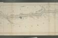
Map of the Hudson River Rail Road from New York to Albany / engraved by Robt. Haering, N.Y. ; W.C. Moore, del.
from Hudson River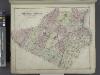
Outline Plan of Orange County New York.
from County atlas of Orange, New York / from actual surveys by and under the direction of F.W. Beers.
Map of the Hudson ... from Tarrytown to Dunderbergh.
from Map of the Hudson between Sandy Hook & Sandy Hill : with the post road between New York and Albany / Bridges delt. ; Rollinson sct.
![Fishkill on the Hudson [Village]](https://images-2.georeferencer.com/images/iiif/179877636961/full/,300/0/native.jpg)

