Maps of Columbia County

Ghent [Village]; Harlemville [Village]; Ghent Business Notices.; Harlemville Business Notices.; Green River [Village]; Green River Business Notices.; Hillsdale Business Notices.; Hillsdale [Village]
from Atlas of Columbia County, New York. From actual surveys and official records. Compiled & published by D. G. Beers & Co.
Hillsdale
1 : 24000
Hillsdale
1 : 24000
Hillsdale
1 : 24000
Hillsdale
1 : 24000
Hillsdale [Township]
from Atlas of Columbia County, New York. From actual surveys and official records. Compiled & published by D. G. Beers & Co.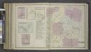
Charyville [Village]; Copake Station [Village]; Copake Flats [Village]; Gallatinville [Village]; Copake Business Notices.; Copake [Township]
from Atlas of Columbia County, New York. From actual surveys and official records. Compiled & published by D. G. Beers & Co.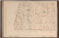
Massachusetts. Atlas Plate No. 27.
1 : 63360 Walker, O.W.
Copake
1 : 62500
Copake
1 : 62500
Copake
1 : 62500
Copake
1 : 62500
Copake
1 : 62500
Copake
1 : 62500
Copake
1 : 62500
Copake
1 : 62500
New York
1 : 2000000 Breese, S.
Pittsfield
1 : 100000
Pittsfield
1 : 100000
Hudson River & vicinity / drawn by David H. Burr ; S. Stiles & Co., N.Y.
from Hudson River
Columbia Co.
from Atlas of Columbia County, New York. From actual surveys and official records. Compiled & published by D. G. Beers & Co.
Map of the county of Berkshire, Massachusetts : based upon the trigonometrical survey of the state
1 : 50688 Walling, Henry Francis, 1825-1888 Smith, Gallup & Co.
Map of the county of Greene / by David H. Burr ; engd. by Rawdon, Clark & Co., Albany, & Rawdon, Wright & Co., New York.
from An atlas of the state of New York : containing a map of the state and of the several counties. / Projected and drawn under the superintendence and direction of Simeon de Witt ... And also the physical geography of the State ...
Albany, Rensselaer, Columbia counties.
1 : 158400 Bien, Joseph Rudolf
Plan of the encampment and position of the army under His Excelly. Lt. General Burgoyne at Swords House on Hudson's River near Stillwater on Septr. 17th : with the positions of that part of the army engaged on the 19th Septr. 1777 / drawn by W. C. Wilkin
from Revolutionary War
Map of the county of Greene / by David H. Burr ; engd. by Rawdon, Clark & Co., Albany, & Rawdon, Wright & Co., New York.
from An atlas of the state of New York : containing a map of the state and of the several counties / by David H. Burr.
[Dutchess County].
from New York Atlas.
Map of the counties of Dutchess and Putnam / by David H. Burr ; engd. by Rawdon, Clark & Co., Albany, & Rawdon, Wright & Co., New York.
from An atlas of the state of New York : containing a map of the state and of the several counties / by David H. Burr.
Map of the county of Columbia / by David H. Burr ; engd. by Rawdon, Clark & Co., Albany, & Rawdon, Wright & Co., New York.
from An atlas of the state of New York : containing a map of the state and of the several counties. / Projected and drawn under the superintendence and direction of Simeon de Witt ... And also the physical geography of the State ...
![Ghent [Village]; Harlemville [Village]; Ghent Business Notices.; Harlemville Business Notices.; Green River [Village]; Green River Business Notices.; Hillsdale Business Notices.; Hillsdale [Village]](https://images-2.georeferencer.com/images/iiif/806678338541/full/,300/0/native.jpg)

