Maps of City of Troy

Green Islands [Village]; Green Islands Business Directory.
from New topographical atlas of the counties of Albany and Schenectady, New York : from actual surveys / by S.N. & D.G. Beers and assistants.
Troy.
from Atlas of New York.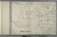
City of Troy
from Map of the city of Troy, West Troy and Green Island, N.Y. : from actual surveys / by William Barton.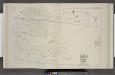
Parts of Wards 4, 5, 7. & 10. [Plate I.]
from City atlas of Troy, New York : from official records, private plans and actual surveys.
Plan Oakwood Cemetery ; Part of the Town of Brunswick. [Plate T.]
from City atlas of Troy, New York : from official records, private plans and actual surveys.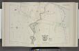
Parts of Wards 5, 10. & 13. [Plate H.]
from City atlas of Troy, New York : from official records, private plans and actual surveys.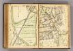
252-253 Mt. Kisco.
1 : 7200 G.W. Bromley & Co.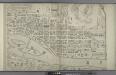
City of Troy [cont.]
from Map of the city of Troy, West Troy and Green Island, N.Y. : from actual surveys / by William Barton.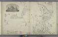
Troy University. Mount Ida. ; City of Troy [cont.]
from Map of the city of Troy, West Troy and Green Island, N.Y. : from actual surveys / by William Barton.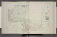
Parts of Wards 1, 2, 3, 5. & 8. [Plate J.]
from City atlas of Troy, New York : from official records, private plans and actual surveys.
Parts of Wards 3 & 4. [Plate B.]
from City atlas of Troy, New York : from official records, private plans and actual surveys.
Part of Ward 10. [Plate E.]
from City atlas of Troy, New York : from official records, private plans and actual surveys.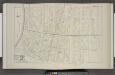
Parts of Wards 4 & 7. [Plate C.]
from City atlas of Troy, New York : from official records, private plans and actual surveys.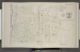
Parts of Wards 7 & 10. [Plate D.]
from City atlas of Troy, New York : from official records, private plans and actual surveys.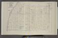
Parts of Wards 2 & 3. [Plate A.]
from City atlas of Troy, New York : from official records, private plans and actual surveys.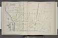
Part of Ward 13. [Plate F.]
from City atlas of Troy, New York : from official records, private plans and actual surveys.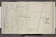
Part of Ward 13. [Plate G.]
from City atlas of Troy, New York : from official records, private plans and actual surveys.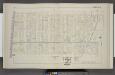
Parts of Wards 1 & 8. [Plate K.]
from City atlas of Troy, New York : from official records, private plans and actual surveys.
Index Map City of Troy, N.Y.
from City atlas of Troy, New York : from official records, private plans and actual surveys.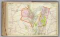
35 Albany, Rensselaer counties, Troy. Cohoes.
1 : 14400 Watson & Co. (New York, N.Y.)
Troy, N.Y., from actual survey / by S.A. Beers, civl. engineer.
from Cities and towns, A-Z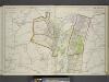
Portion of Albany County. and City of Cohoes. ; Portion of Rensselaer County. And Cities of Lansingburgh & Troy.
from Atlas of the Hudson River Valley from New York city to Troy, including a section of about 8 miles in width. Published by Watson & co. Compiled from official records and careful surveys, under the supervision of F. W. Beers.
Troy South
1 : 24000
Troy South
1 : 24000
Troy South
1 : 24000
Troy South
1 : 24000
Troy South
1 : 24000
Troy South
1 : 24000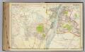
34 Albany, Rensselaer counties, Troy.
1 : 14400 Watson & Co. (New York, N.Y.)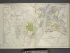
![Green Islands [Village]; Green Islands Business Directory.](https://images-2.georeferencer.com/images/iiif/407791767566/full/,300/0/native.jpg)

