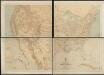
Maps of United States
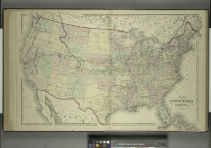
Map of the United States and Territories
from Combination atlas map of Broome County, New York; / compiled, drawn and published from personal examinations and surveys by Everts, Ensign & Everts.
Railroad map of the United States to accompany the "Commercial travellers guide book".
From Whole
Map of the United States, constructed from the latest authorities / J.H. Young, sc.
from Whole
A new map of the United States of America
1 : 8750000 Facsimile. "The United States in 1856 as reproduced by Rand McNally & Company to commemorate its one hundredth anniversary in 1956." Relief shown by hachures. Shows railroad routes proposed to the Pacific Ocean. Includes insets: Gold region of California and District of Columbia. Longitude on top of map "West from Greenwich;" on bottom "East/West from Washington." Printed with ornamental border. "Entered according to Act of Congress in the year 1856 by Charles Desilver, in the Clerks office of the District court of the Eastern District of Pennsylvania." Screen reader support enabled. Young, J. H. (James Hamilton) Philadelphia : Published by Charles Desilver, 1856. ([Chicago] : Rand Mcnally 1956)
Etats-Unis de l'Amerique en 1860.
1 : 12000000 Garnier, F. A., 1803-1863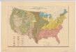
Distribution of the great soil groups (soil provinces)
1 : 8000000 Relief shown by spot heights. Appears in Washington: U.S. Dept. of Agriculture. Atlas of American agriculture, 1936. Soils, plate 2. Marbut, Curtis Fletcher, 1863-1935. Washington, D.C. : Bureau of Chemistry and Soils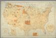
Map showing the location of the Indian reservations within the limits of the United States and territories / compiled from official and other authentic sources, under the direction of the Hon. John D.C. Atkins, Commissioner of Indian Affairs ; Paul Brodi
from Whole
Map of the United States of America with its territories & districts : including also a part of upper & lower Canada and Mexico.
from Whole
United States of America.
1 : 22000000 Colton, G.W.
Vereinigte Staaten Von Nordamerika

Vereinigte Staaten von Nord-America
1 : 13000000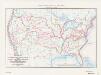
Map of the conterminous United States showing routes of the principal explorers from 1501 to 1844, whose work had an important bearing on the settlement of the country and the fixing of its successive boundaries
1 : 8500000 "Taken from Bulletin 1212, Plate 1." Original title: United States map showing routes of principal explorers and early roads and highways. Bond, Frank, 1856-1940 United States. General Land Office.; Geological Survey (U.S.); Reston, Virginia : U.S. Geological Survey
Routen der Missouri - Pacific, sowie der Wabash St. Louis und Pacific Eisenbahnen
Carte Generale Des Etats.
1 : 7285000 Andriveau-Goujon, E.
United States / Geo. Boynton, sc., Boston.
from Whole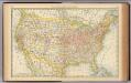
United States.
1 : 10560000 Rand McNally and Company
194-195. United States of America. The World Atlas.
1 : 10000000 USSR (Union of Soviet Socialist Republics).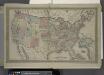
Map of The United States
from Atlas of Franklin County, New York. : From actual surveys and official records.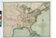
The traveller's guide : a new and correct map of the United States, including great portions of Missouri Territory, Upper & Lower Canada, Nova Scotia, New Brunswick, the Floridas, Spanish provinces &c. / collected and compiled from the most undoubted aut
from Whole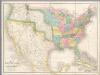
Map of the United States Of North America.
1 : 4118400 Burr, David H., 1803-1875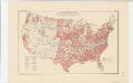
Areas covered by the soil survey, completed to January 1934
1 : 7900000 Includes numbered list of reconnaissance surveys. "Atlas of American Agriculture, Soils, Plate 1." United States. Bureau of Chemistry and Soils. [Washington, D.C.?] : The Bureau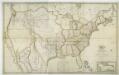
Map of the United States with the contiguous British & Spanish possessions / compiled from the latest & best authorities by John Melish; engraved by J. Vallance & H.S. Tanner.
from Whole John Melish; J. Vallance; Henry S. Tanner,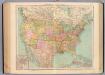
127-28. Stati Uniti.
1 : 10000000 Touring club italiano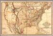
Fredonia Or The United States of North America.
1 : 570000 Laurie, Richard Holmes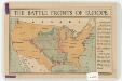
The battle fronts of Europe
1 : 2500000 Map of battle fronts drawn to scale upon a map of the United States showing relative distances of fronts. Roberts & Leete. London : Stanford's Geographical Establishment
Hypsometric sketch US.
1 : 10400000 United States. Census Office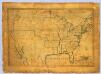
United States.
1 : 7700000 Symonds, Maria
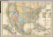
Map of the United States and Mexico: including Oregon, Texas and the Californias.
from Parts s.n.: [New York?],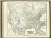
Vereinigten Staaten von N. America.
1 : 8000000 Kiepert, Heinrich, 1818-1899