Maps of Queens County

M-T-10-122: [Bounded by (The Lake) East Drive, East 73rd Street, East 72nd Street, East 74th Street and East 70th Street.]
from Topographical survey of portion of Central Park, Boro. of Manhattan ... / City of New York, Department of Parks, Topographical Division.
M-T-10-124: [Bounded by (The Lake) East Drive, East 69th Street, East 68th Street, East 67th Street and East 66th Street.]
from Topographical survey of portion of Central Park, Boro. of Manhattan ... / City of New York, Department of Parks, Topographical Division.
M-T-10-120: [Bounded by (The Lake) East Drive, East 77th Street, East 76th Street, East 75th Street and East 74th Street.]
from Topographical survey of portion of Central Park, Boro. of Manhattan ... / City of New York, Department of Parks, Topographical Division.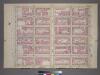
Plate 24, Part of Section 5: [Bounded by E. 77th Street, Third Avenue, E.71st Street and Fifth Avenue.]
from Atlas of the city of New York, borough of Manhattan. From actual surveys and official plans / by George W. and Walter S. Bromley.
Part of Section 5: Plate 110.
from Atlas of the borough of Manhattan, city of New York.
Plate 106: Bounded by E. 71st Street, Third Avenue, E. 65th Street and (Central Park) Fifth Avenue.
From Atlas of the borough of Manhattan, city of New York.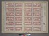
Plate 24, Part of Section 5: [Bounded by E. 77th Street, Third Avenue, E. 71st Street and (Central Park) Fifth Avenue.]
from Atlas of the city of New York, borough of Manhattan. From actual surveys and official plans / by George W. and Walter S. Bromley.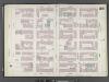
Manhattan, V. 8, Double Page Plate No. 155 [Map bounded by E. 78th St., 3rd Ave., E. 72nd St., 5th Ave.]
From Atlas 122. Vol. 8, 1896.
M-T-10-121: [Bounded by West 70th Street, West 71st Street, West 72nd Street, West 73rd Street and the Lake.]
from Topographical survey of portion of Central Park, Boro. of Manhattan ... / City of New York, Department of Parks, Topographical Division.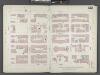
Manhattan, V. 6, Double Page Plate No. 122 [Map bounded by E. 72nd St., 5th Ave., E. 67th St., 3rd Ave.]
From Atlas 117. Vol. 6, 1892.
Plate 122: Map bounded by East 72nd Street, Third Avenue, East 67th Street, Fifth Avenue
from Maps of the city of New York.
M-T-10-123: [Bounded by West 66th Street, West 67th Street, West 68th Street, West 69th Street and the Lake.]
from Topographical survey of portion of Central Park, Boro. of Manhattan ... / City of New York, Department of Parks, Topographical Division.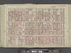
Manhattan, Double Page Plate No. 28 [Map bounded by 5th Ave., E. 80th St., 2nd Ave., E. 64th St.]
From Atlas of the city of New York, Manhattan Island. From actual surveys and official plans
Sackersdorff Farm Set.
from Maps of farms commonly called the Blue book, 1815 : drawn from the original on file in the street commissioner's office in the City of New York, together with lines of streets and avenues / laid out by John Randel, jr., 1819-20.
Sackersdorff Farm set.
from Maps of farms commonly called the Blue book, 1815 : drawn from the original on file in the street commissioner's office in the City of New York, together with lines of streets and avenues / laid out by John Randel, jr., 1819-20.
[Plate 22: Bounded by Sixth Avenue, Central Park South, Fifth Avenue, E. 64th Street, Lexington Avenue, and E. 47th Street.]
from Atlas of the city of New York, borough of Manhattan. From actual surveys and official plans / by George W. and Walter S. Bromley.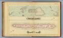
41. Central Park, Blackwells Island.
1 : 6000 G.W. Bromley & Co.; Geo. W. Bromley & E. Robinson
Central Park
from Manhattan
Manhattan V. 7, Plate No. 55 [Map bounded by Columbus Ave., Cathedral Parkway, Central Park West, W. 108th St.]
From Atlas 121. Vol. 7, pt. 1, 1912.
Plate 19: Bounded by E. 76th Street, East River (Avenue A), E. 64th Street, and Fifth Avenue.
from Atlas of the city of New York : embracing all territory within its corporate limits from official records, private plans & actual surveys / by and under the supervision of E. Robinson & R.H. Pidgeon, civil engineers.
[Plate 28: Bounded by Fifth Avenue, E. 80th Street, Second Avenue, and E. 84th Street.]
from Atlas of the city of New York, Manhattan Island. From actual surveys and official plans / by George W. and Walter S. Bromley.
[Plate 28: Bounded by Fifth Avenue, E. 80th Street, Second Avenue, and E. 64th Street.]
from Atlas of the city of New York, borough of Manhattan. From actual surveys and official plans / by George W. and Walter S. Bromley.
Manhattan, V. 7, Plate No. 64 [Map bounded by Central Park West, 5th Ave.]
From Atlas 120. Vol. 7, 1902.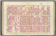
Pl. 28: ward 19.
1 : 1800 Bromley, George Washington; Bromley, Walter Scott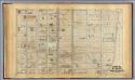
20. Ward 19.
1 : 2400 G.W. Bromley & Co.; Geo. W. Bromley & E. Robinson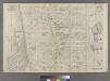
Part of Ward 22, New York City.
from Atlas of the city of New York : embracing all territory within its corporate limits from official records, private plans & actual surveys / by and under the supervision of E. Robinson & R.H. Pidgeon, civil engineers.
Part of Section 5: Plate 106.
from Atlas of the borough of Manhattan, city of New York.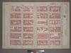
Plate 23, Part of Section 5: [Bounded by E. 71st Street, Third Avenue, E. 65th Street and (Central Park) Fifth Avenue.]
from Atlas of the city of New York, borough of Manhattan. From actual surveys and official plans / by George W. and Walter S. Bromley.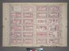
Plate 23, Part of Section 5: [Bounded by E. 71st Street, Third Avenue, E. 65th Street and Fifth Avenue.]
from Atlas of the city of New York, borough of Manhattan. From actual surveys and official plans / by George W. and Walter S. Bromley.
![M-T-10-122: [Bounded by (The Lake) East Drive, East 73rd Street, East 72nd Street, East 74th Street and East 70th Street.]](https://images-2.georeferencer.com/images/iiif/142973324356/full/,300/0/native.jpg)

