Maps of Bronx County
Atlas of the borough of the Bronx, city of New York : based upon official plans and maps on file in the various city offices; supplemented by careful field measurements and personal observations, by and under the supervision of Hugo Ullitz.
from Atlas of the borough of the Bronx, city of New York : based upon official plans and maps on file in the various city offices; supplemented by careful field measurements and personal observations, by and under the supervision of Hugo Ullitz.
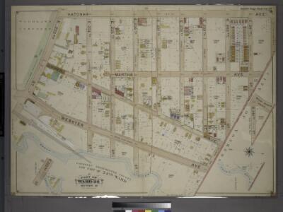
39 ward 24.
1 : 1800 Bromley, George Washington; Bromley, Walter Scott; G.W. Bromley & Co.
Plate 81, Part of Section 13, Borough of the Bronx. [Bounded by Van Cortlandt Park East, E. 242nd Street, Martha Avenue, E. 240th Street, McClean Avenue, Webster Avenue and E. 233rd Street.]
from Atlas of borough of the Bronx, Sections 9 10 11 12 & 13 : from actual surveys and official plans / G.W. Bromley and Co.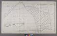
Map or Plan of Section 19. [Bounded by Jerome Avenue, E. 233rd Street, Mount Vernon Avenue, E. 239th Street, Vireo Avenue and Webster Avenue.]
from Maps or plans and profiles, with field notes and explanatory remarks, showing the location, width, grades, and class of streets, roads, avenues, public squares and places, located and laid out by the Commissioner of Street Improvements of the 23rd and 24th wards of the city of New York : under authority of Chapter 545 of the laws of 1890.
Planning Grid of the Office of the Topographical Bureau of Bronx.
from Topographical survey sheets of the borough of the Bronx easterly of the Bronx River.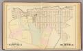
Olinville, Wakefield.
1 : 4800 Bromley, George Washington; Bromley, Walter Scott; G.W. Bromley & Co.
Plate 17: Map of the Woodlawn Cemetery, incorporated December 29th, 1863.
from Atlas of New York and vicinity : from actual surveys / by and under the direction of F. W. Beers, assisted by A. B. Prindle & others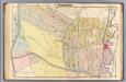
19. Yonkers.
1 : 2400 Kiser, Ellis; Mueller, A. H.
Atlas of the borough of the Bronx, city of New York : based upon official plans and maps on file in the various city offices; supplemented by careful field measurements and personal observations, by and under the supervision of Hugo Ullitz.
from Atlas of the borough of the Bronx, city of New York : based upon official plans and maps on file in the various city offices; supplemented by careful field measurements and personal observations, by and under the supervision of Hugo Ullitz.
Westchester, Double Page Plate No. 10 [Map bounded by 15th Ave., City of Yonkers, Mount Vernon Ave.] / prepared under the direction of Joseph R. Bien, from general surveys and official records.
From Atlas of Westchester County, New York
Bronx, Topographical Map Sheet 2; [Map bounded by Midland Ave., Mc. Lean Ave., New York and Harlem Railroad, Mosholu Ave.; Including Croton Aqueduct, New York and Boston Railroad, Tibbet's Brook]
From Topographical map made from surveys by the commissioners of the Department of Public Parks of the City of New York of that part of Westchester County adjacent to the City and County of New York embraced by chapter 534 of laws of 1871 as amended b...
2A - N.Y. City (Aerial Set).
from Sectional aerial maps of the City of New York / [photographed and assembled under the direction of the chief engineer, July 1st, 1924].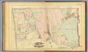
40. Ward 24.
1 : 7200 G.W. Bromley & Co.; Geo. W. Bromley & E. Robinson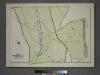
Plate 82, Part of Section 13, Borough of the Bronx. [Bounded by Broadway, Van Cortlandt Park South, Gun Hill Road, E. 211th Street, Webster Avenue, E. 233rd Street and Mt. Vernon Avenue.]
from Atlas of borough of the Bronx, Sections 9 10 11 12 & 13 : from actual surveys and official plans / G.W. Bromley and Co.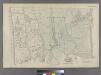
Part of Ward 24, New York City.
from Atlas of the city of New York : embracing all territory within its corporate limits from official records, private plans & actual surveys / by and under the supervision of E. Robinson & R.H. Pidgeon, civil engineers.
Plate 52: Wakefield, Town & County of Westchester, N.Y.
from County atlas of Westchester, New York. Published by J.B. Beers & Co., assisted by S.W. Wilson and others.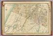
1 Atlas rural country district north of New York City.
1 : 13000 Hyde, E. Belcher
Area District Map Section No. 2
from Area district map / City of New York, Board of Estimate and Apportionment.
Riderdale, Fieldston, Kingsbridge, North Riverdale, Spuyten Duyvil
From District 14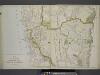
Plan of Southern part of the City of Yonkers.
from Atlas of the Hudson River Valley from New York city to Troy, including a section of about 8 miles in width. Published by Watson & co. Compiled from official records and careful surveys, under the supervision of F. W. Beers.
Westchester, Pelham towns.
1 : 21120 Bien, Joseph Rudolf
Hammods Atlas of New York City and the metropolitan district

Topographical atlas of the city of New York, including the annexed territory showing original water courses and made land. / prepared under the direction of Egbert L. Viele.
From Topographical atlas of the city of New York, including the annexed territory showing original water courses and made land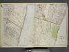
Portion of Bergen County, N.J.; Portion of Yonkers and 24th Ward.
from Atlas of the Hudson River Valley from New York city to Troy, including a section of about 8 miles in width. Published by Watson & co. Compiled from official records and careful surveys, under the supervision of F. W. Beers.
Yonkers and East Chester, Westchester County, New York.
1 : 23760 Beers, J.B.
Yonkers, Town.
1 : 19800 Beers, F. W. (Frederick W.)
Yonkers, Mt. Vernon, Eastchester towns.
1 : 21120 Bien, Joseph Rudolf
Mount Vernon
1 : 24000
Mount Vernon
1 : 24000
Mount Vernon
1 : 24000
Mount Vernon
1 : 24000
Mount Vernon
1 : 24000
Mount Vernon
1 : 24000
Mount Vernon
1 : 24000