Maps of Bronx County

Double Page Plate No. 15, Part of Ward 24, Section 11. [Bounded by Commerce Avenue, E. 177th Street and Montgomery Avenue.]
from Atlas of the borough of the Bronx, city of New York : based upon official plans and maps on file in the various city offices; supplemented by careful field measurements and personal observations, by and under the supervision of Hugo Ullitz.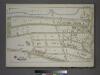
Plate 43, Part of Section 11, Borough of the Bronx. [Bounded by West Tremont Avenue, Andrews Avenue W. 176th Street and University Avenue.]
from Atlas of borough of the Bronx, Sections 9 10 11 12 & 13 : from actual surveys and official plans / G.W. Bromley and Co.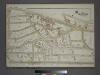
Plate 44, Part of Section 11, Borough of the Bronx. [Bounded by University Avenue, W. 176th Street, Andrews Avenue, West Tremont Avenue, W. 177th Street, Jerome Avenue and W. 179th Street.]
from Atlas of borough of the Bronx, Sections 9 10 11 12 & 13 : from actual surveys and official plans / G.W. Bromley and Co.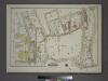
Plate 55, Part of Section 11, Borough of the Bronx. [Bounded by W. 180th Street, Loring Place, W. 179th Street, Burnside Avenue, Harrison Avenue, W. Tremont Avenue and (Harlem River Piers) Cedar Avenue.]
from Atlas of borough of the Bronx, Sections 9 10 11 12 & 13 : from actual surveys and official plans / G.W. Bromley and Co.
Bronx, V. 15, Plate No. 10 [Map bounded by Featherbed Lane, Jesup Ave., W. 172nd St., Plimpton Ave.]
From Atlas 53.1. Vol. 15, 1915.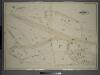
Double Page Plate No. 14, Part of Ward 24, Section 11. [Bounded by Montgomery Avenue, E. 177th Street, Aqueduct Avenue, Grand Avenue, Harrison Avenue and Featherbed Lane.]
from Atlas of the borough of the Bronx, city of New York : based upon official plans and maps on file in the various city offices; supplemented by careful field measurements and personal observations, by and under the supervision of Hugo Ullitz.
Part of Section 8: Plate 175
from Atlas of the borough of Manhattan, city of New York.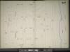
Manhattan, V. 11 1/2, Double Page Plate No. 247 [Map bounded by W. 187th St., Harlem River, Reynolds Place., Broadway]
From Atlas 42.61. Vol. 11-11 1/2, 1893.
Plate 177: Bounded by Fairview Avenue, (Isabella Heimath Home), Amsterdam Avenue (Harlem River),W. 189th Street, W. 190th Street and Wadsworth Terrace.
from Atlas of the borough of Manhattan, city of New York.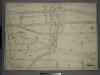
Double Page Plate No. 1, Part of Ward 24, Section 9. [Bounded by Harlem River, Old Croton Aqueduct, Nelson Avenue, E. 170th St., and High Bridge.]
from Atlas of the borough of the Bronx, city of New York : based upon official plans and maps on file in the various city offices; supplemented by careful field measurements and personal observations, by and under the supervision of Hugo Ullitz.
Manhattan, V. 12, Plate No. 26 [Map bounded by St. Nicholas Ave., W. 191st St., Amsterdam Ave., W. 188th St.]
From Atlas 129. Vol. 12, 1913.
Manhattan, V. 12, Plate No. 25 [Map bounded by St. Nicholas Ave., W. 188th St., Laurel Hill Terrace, W. 185th St.]
From Atlas 129. Vol. 12, 1913.
Manhattan, V. 12, Plate No. 31 [Map bounded by St. Nicholas Ave., Amsterdam Ave.]
From Atlas 129. Vol. 12, 1913.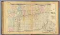
32. Ward 12.
1 : 3600 G.W. Bromley & Co.; Geo. W. Bromley & E. Robinson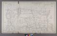
Section 15 of Final Maps and Profiles, of the 23rd & 24th Wards.
from Maps or plans and profiles, with field notes and explanatory remarks, showing the location, width, grades, and class of streets, roads, avenues, public squares and places, located and laid out by the Commissioner of Street Improvements of the 23rd and 24th wards of the city of New York : under authority of Chapter 545 of the laws of 1890.
Plate 9: Tremont : Town of West Farms.
from Atlas of New York and vicinity : from actual surveys / by and under the direction of F. W. Beers, assisted by A. B. Prindle & others
Part of Section 8: New York City.
from Atlas of the city of New York, Manhattan Island. From actual surveys and official plans / by George W. and Walter S. Bromley.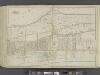
Manhattan, Double Page Plate No. 44 [Map bounded by Hudson River, Harlem River]
From Atlas of the city of New York, Manhattan Island. From actual surveys and official plans
Sheet 19: [Bounded by Hudson River Bulk Head Pier Line, Fort Washington, 10th Avenue (Harlem River Bulk Head Pier Line) and 160th Street.]
from Plan of New York City, from the Battery to Spuyten Duyvil Creek. Showing every lot and building thereon; old farm lines, strreet numbers at the corners of blocks, railroads, steamboat landings, bulkhead and pier lines, etc. Based on the surveys made by Messrs. Randall & Blackwell, and on the special survey by J. F. Harrison.
Page 24: [Bounded by 199th Street, Harlem River, 177th Street and Hudson River.]
from Sackersdorf Farm Set.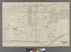
[Plate 31: Bounded by Harlem River, W. 166th Street, Hudson River...]
from Atlas of the city of New York : embracing all territory within its corporate limits from official records, private plans & actual surveys / by and under the supervision of E. Robinson & R.H. Pidgeon, civil engineers.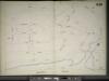
Manhattan, V. 11 1/2, Double Page Plate No. 249 [Map bounded by Broadway, Harlem River, W. 187th St.]
From Atlas 42.61. Vol. 11-11 1/2, 1893.
Plate 16: Tremont, Town of West Farms, Westchester Co. N.Y.
from County atlas of Westchester, New York. Published by J.B. Beers & Co., assisted by S.W. Wilson and others.
Sheet 20: [Bounded by 225th Street, (Spuyten Duyvel Creek Bulk Head Pier Line), 10th Avenue and 195th Street.]
from Plan of New York City, from the Battery to Spuyten Duyvil Creek. Showing every lot and building thereon; old farm lines, strreet numbers at the corners of blocks, railroads, steamboat landings, bulkhead and pier lines, etc. Based on the surveys made by Messrs. Randall & Blackwell, and on the special survey by J. F. Harrison.
[Plate 47: Bounded by Harlem River, W. 182nd Street, W. 183rd Street, and Hudson River.]
from Atlas of the city of New York, borough of Manhattan. From actual surveys and official plans / by George W. and Walter S. Bromley.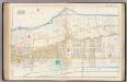
Pl. 44: ward 12.
1 : 3600 Bromley, George Washington; Bromley, Walter Scott
Fort Washington section.
From Manhattan
Fort Washington section.
From Manhattan
Manhattan, V. 12, Plate No. 12 [Map bounded by Harlem River, Amsterdam Ave.]
From Atlas 128. Vol. 12, 1900.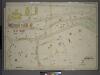
![Double Page Plate No. 15, Part of Ward 24, Section 11. [Bounded by Commerce Avenue, E. 177th Street and Montgomery Avenue.]](https://images-2.georeferencer.com/images/iiif/442774586616/full/,300/0/native.jpg)

