Maps of Bronx County
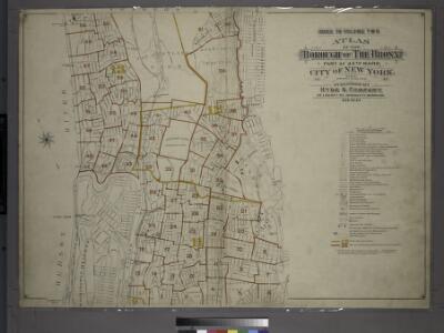
Index to Volume Two: Atlas of the Borough of the Bronx, City of New York. Part of 24th Ward.
from Atlas of the borough of the Bronx, city of New York : based upon official plans and maps on file in the various city offices; supplemented by careful field measurements and personal observations, by and under the supervision of Hugo Ullitz.
Morrisania, Westchester Co. N.Y.
from County atlas of Westchester, New York. Published by J.B. Beers & Co., assisted by S.W. Wilson and others.
2. Harlem-Yonkers-Pelham Manor.
1 : 80000 Servoss, R. D.
2. Harlem-Yonkers-Pelham Manor.
1 : 80000 Servoss, R. D.
Map of the Borough of the Bronx, City of New York, showing street pavements on January 1st, 1913.
From Bronx
1 Bronx.
1 : 18000 Hyde & Company
Plates 21 & 22: Town and City of Yonkers, Westchester Co. N.Y. - Town of East Chester, Westchester Co. N.Y.
From County atlas of Westchester, New York. Published by J.B. Beers & Co., assisted by S.W. Wilson and others.
Hammods Atlas of New York City and the metropolitan district

Plans of Westchester, West Farms, Morrisania, Westchester County and Part of New York County. New York.
1 : 42240 Beers, Frederick W.
From New York to Stratford. (2)
1 : 35000 Colles, Christopher
Plates 21 & 22: Town and City of Yonkers, Westchester Co. N.Y. - Town of East Chester, Westchester Co. N.Y.
from County atlas of Westchester, New York. Published by J.B. Beers & Co., assisted by S.W. Wilson and others.
Topographical atlas of the city of New York, including the annexed territory showing original water courses and made land. / prepared under the direction of Egbert L. Viele.
From Topographical atlas of the city of New York, including the annexed territory showing original water courses and made land
Plate 50: Town of Westchester, Westchester Co. N.Y.
from County atlas of Westchester, New York. Published by J.B. Beers & Co., assisted by S.W. Wilson and others.
[Map of the city of New York and island of Manhattan as laid out by the commissioners appointed by the Legislature, April 3, 1807]
From Manhattan
Topographical atlas of the city of New York, including the annexed territory showing original water courses and made land. / prepared under the direction of Egbert L. Viele.
From Topographical atlas of the city of New York, including the annexed territory showing original water courses and made land
Westchester, Pelham towns.
1 : 21120 Bien, Joseph Rudolf
Portion of Bergen County, N.J.; Portion of Yonkers and 24th Ward.
from Atlas of the Hudson River Valley from New York city to Troy, including a section of about 8 miles in width. Published by Watson & co. Compiled from official records and careful surveys, under the supervision of F. W. Beers.
Height District Map Section No. 1
from Height district map / City of New York, Board of Estimate and Apportionment.
Riderdale, Fieldston, Kingsbridge, North Riverdale, Spuyten Duyvil
From District 14
Washington Heights, Inwood, Marble Hill. (cont.)
From District 12
Key
From Atlas 128. Vol. 12, 1900.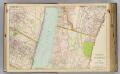
4 Yonkers, Bergen Co.
1 : 14400 Watson & Co. (New York, N.Y.)
Area District Map Section No. 4
from Area district map / City of New York, Board of Estimate and Apportionment.
Area District Map Section No. 2
from Area district map / City of New York, Board of Estimate and Apportionment.
W. Farms, Morrisania.
1 : 15840 Beers, F. W. (Frederick W.)
Outline and Index Map, Sections 9 and 10, Borough of the Bronx.
from Atlas and owners names, borough of the Bronx, sections 9 & 10 : from actual surveys and official plans / by George W. and Walter S. Bromley.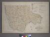
Outline and Index Map of the 23rd Ward, City of New York.
from Atlas of the city of New York : from official records, private plans & actual surveys / compiled under the supervision of E. Robinson & R. H. Pidgeon.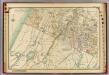
1 Atlas rural country district north of New York City.
1 : 13000 Hyde, E. Belcher
Plate 52: Wakefield, Town & County of Westchester, N.Y.
from County atlas of Westchester, New York. Published by J.B. Beers & Co., assisted by S.W. Wilson and others.