Maps of Bronx County
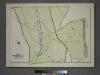
Plate 82, Part of Section 13, Borough of the Bronx. [Bounded by Broadway, Van Cortlandt Park South, Gun Hill Road, E. 211th Street, Webster Avenue, E. 233rd Street and Mt. Vernon Avenue.]
from Atlas of borough of the Bronx, Sections 9 10 11 12 & 13 : from actual surveys and official plans / G.W. Bromley and Co.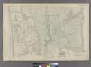
Part of Ward 24, New York City.
from Atlas of the city of New York : embracing all territory within its corporate limits from official records, private plans & actual surveys / by and under the supervision of E. Robinson & R.H. Pidgeon, civil engineers.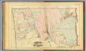
40. Ward 24.
1 : 7200 G.W. Bromley & Co.; Geo. W. Bromley & E. Robinson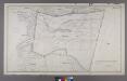
Section 27 of Final Maps and Profiles, of the 23rd & 24th Wards.
from Maps or plans and profiles, with field notes and explanatory remarks, showing the location, width, grades, and class of streets, roads, avenues, public squares and places, located and laid out by the Commissioner of Street Improvements of the 23rd and 24th wards of the city of New York : under authority of Chapter 545 of the laws of 1890.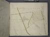
Bronx, Topographical Map Sheet 2; [Map bounded by Midland Ave., Mc. Lean Ave., New York and Harlem Railroad, Mosholu Ave.; Including Croton Aqueduct, New York and Boston Railroad, Tibbet's Brook]
From Topographical map made from surveys by the commissioners of the Department of Public Parks of the City of New York of that part of Westchester County adjacent to the City and County of New York embraced by chapter 534 of laws of 1871 as amended b...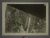
1B - N.Y. City (Aerial Set).
from Sectional aerial maps of the City of New York / [photographed and assembled under the direction of the chief engineer, July 1st, 1924].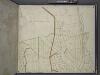
Bronx, Topographical Map Sheet 4; [Map bounded by Mosholu Ave., Jerome Ave., Bronx River, Richard St., Lorillard Terrace, Tillotson Ave., Railroad Ave., Hull Ave., Perry Ave., Bainbridge Ave., Briggs Ave., Carlin PL.; Including Marion Ave., Antony Ave...
From Topographical map made from surveys by the commissioners of the Department of Public Parks of the City of New York of that part of Westchester County adjacent to the City and County of New York embraced by chapter 534 of laws of 1871 as amended b...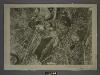
1D - N.Y. City (Aerial Set).
from Sectional aerial maps of the City of New York / [photographed and assembled under the direction of the chief engineer, July 1st, 1924].
Plates 23 & 24: Southern Part of Yonkers and portion of West Farms.
from County atlas of Westchester, New York. Published by J.B. Beers & Co., assisted by S.W. Wilson and others.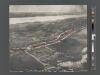
Van Cortlandt Estate to be sold. [Bird's eye view of the environs of the Van Cortlandt estate, Broadway, Van Cortlandt Park, etc.]
From Bronx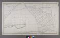
Map or Plan of Section 19. [Bounded by Jerome Avenue, E. 233rd Street, Mount Vernon Avenue, E. 239th Street, Vireo Avenue and Webster Avenue.]
from Maps or plans and profiles, with field notes and explanatory remarks, showing the location, width, grades, and class of streets, roads, avenues, public squares and places, located and laid out by the Commissioner of Street Improvements of the 23rd and 24th wards of the city of New York : under authority of Chapter 545 of the laws of 1890.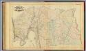
39. Ward 24.
1 : 7200 G.W. Bromley & Co.; Geo. W. Bromley & E. Robinson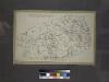
Miniature map of the property of Delafields Estate. Bounded by Riverdale Avenue, Mosholu Avenue, W. 53rd Street, Broadway, W. 238th Street, Spuyten Duyvil, W. 236th Street and Fieldston Road.
from Atlas of the borough of the Bronx, city of New York : based upon official plans and maps on file in the various city offices; supplemented by careful field measurements and personal observations, by and under the supervision of Hugo Ullitz.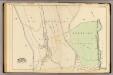
40 ward 24.
1 : 4800 Bromley, George Washington; Bromley, Walter Scott; G.W. Bromley & Co.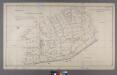
Map or Plan of Section 24. [Bounded by Riverdale Avenue, 253rd Street, Broadway, W. 238th Street and Spuyten Duvil Parkway.]
from Maps or plans and profiles, with field notes and explanatory remarks, showing the location, width, grades, and class of streets, roads, avenues, public squares and places, located and laid out by the Commissioner of Street Improvements of the 23rd and 24th wards of the city of New York : under authority of Chapter 545 of the laws of 1890.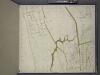
Bronx, Topographical Map Sheet 3; [Map bounded by Bates St., Riverdale Ave., Moshold Ave., Broadway, Vancortlandt Ave., Bailey Ave., Ft. Independence St.; Including Albany Road, Church Kingsbridge Ave., Webbers Lane, Ackerman St., Johnson Ave., Spuyte...
From Topographical map made from surveys by the commissioners of the Department of Public Parks of the City of New York of that part of Westchester County adjacent to the City and County of New York embraced by chapter 534 of laws of 1871 as amended b...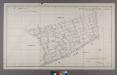
Map or Plan of Section 25. [Bounded by Riverdale Avenue, W. 262nd Street, Broadway and W. 253rd Street.]
from Maps or plans and profiles, with field notes and explanatory remarks, showing the location, width, grades, and class of streets, roads, avenues, public squares and places, located and laid out by the Commissioner of Street Improvements of the 23rd and 24th wards of the city of New York : under authority of Chapter 545 of the laws of 1890.
Plate 20: Yonkers, Westchester Co. N.Y. (Spuyten Duvil.)
from Atlas of New York and vicinity : from actual surveys / by and under the direction of F. W. Beers, assisted by A. B. Prindle & others
Plates 23 & 24: Southern Part of Yonkers and portion of West Farms.
from County atlas of Westchester, New York. Published by J.B. Beers & Co., assisted by S.W. Wilson and others.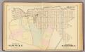
Olinville, Wakefield.
1 : 4800 Bromley, George Washington; Bromley, Walter Scott; G.W. Bromley & Co.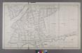
Section 18 of Final Maps and Profiles, of the 23rd & 24th Wards.
from Maps or plans and profiles, with field notes and explanatory remarks, showing the location, width, grades, and class of streets, roads, avenues, public squares and places, located and laid out by the Commissioner of Street Improvements of the 23rd and 24th wards of the city of New York : under authority of Chapter 545 of the laws of 1890.
Sheet 3: Grid #8000E - 12000E, #7000N - 11000N. [Includes E. 213th Street to E. 227th Street, Williams Bridge, Bronx River to Bronxwood Avenue.]
from Topographical survey and new street system of the borough of the Bronx, easterly of the Bronx River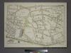
Plate 77, Part of Section 13, Borough of the Bronx. [Bounded by Johnson Avenue, Spuyten Duyvil Road, W. 246th Street, Delafield Avenue, W. 250th Street, Broadway, W. 238th Street, Spuyten Duyvil Road and 236th Street.]
from Atlas of borough of the Bronx, Sections 9 10 11 12 & 13 : from actual surveys and official plans / G.W. Bromley and Co.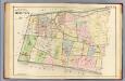
25. N.W. Bronx.
1 : 3600 Kiser, Ellis; Mueller, A. H.
Plate 17: Map of the Woodlawn Cemetery, incorporated December 29th, 1863.
from Atlas of New York and vicinity : from actual surveys / by and under the direction of F. W. Beers, assisted by A. B. Prindle & others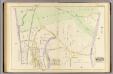
35 ward 24.
1 : 2400 Bromley, George Washington; Bromley, Walter Scott; G.W. Bromley & Co.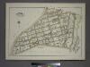
Plate 81, Part of Section 13, Borough of the Bronx. [Bounded by Van Cortlandt Park East, E. 242nd Street, Martha Avenue, E. 240th Street, McClean Avenue, Webster Avenue and E. 233rd Street.]
from Atlas of borough of the Bronx, Sections 9 10 11 12 & 13 : from actual surveys and official plans / G.W. Bromley and Co.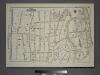
Plate 79, Part of Section 13, Borough of the Bronx. [Bounded by W. W. 250th Street, Broadway, Mosholu Avenue, Post Road, Farraday Avenue, Sylvan Avenue, W. 253rd Street, Fieldston Road, Mosholu Avenue.]
from Atlas of borough of the Bronx, Sections 9 10 11 12 & 13 : from actual surveys and official plans / G.W. Bromley and Co.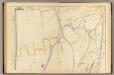
34 ward 24.
1 : 2400 Bromley, George Washington; Bromley, Walter Scott; G.W. Bromley & Co.
![Plate 82, Part of Section 13, Borough of the Bronx. [Bounded by Broadway, Van Cortlandt Park South, Gun Hill Road, E. 211th Street, Webster Avenue, E. 233rd Street and Mt. Vernon Avenue.]](https://images-2.georeferencer.com/images/iiif/589594271273/full/,300/0/native.jpg)

