Maps of Bronx County
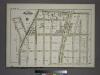
Plate 18, Part of Section 9, Borough of the Bronx. [Bounded by E. 169th Street, Grant Avenue, E. 166th Street and Shakespeare Avenue.]
from Atlas of borough of the Bronx, Sections 9 10 11 12 & 13 : from actual surveys and official plans / G.W. Bromley and Co.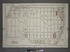
Plate 11: Part of Section 9, Borough of the Bronx. [Bounded by Jerome Avenue, E. 169th Street, Park Avenue, E. 164th Street, E. 165th Street and Cromwell Avenue.]
from Atlas and owners names, borough of the Bronx, sections 9 & 10 : from actual surveys and official plans / by George W. and Walter S. Bromley.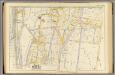
10, ward 23.
1 : 1800 Bromley, George Washington; Bromley, Walter Scott; G.W. Bromley & Co.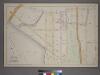
Part of the 23rd Ward, New York City.
from Atlas of the city of New York : from official records, private plans & actual surveys / compiled under the supervision of E. Robinson & R. H. Pidgeon.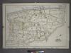
Plate 10: Part of Section 9, Borough of the Bronx. [Bounded by Sedgwick Avenue, Washington Bridge, Boscobel Avenue, Cromwell Avenue, E. 165th Street, Jerome Avenue and E. 165th Street.]
from Atlas and owners names, borough of the Bronx, sections 9 & 10 : from actual surveys and official plans / by George W. and Walter S. Bromley.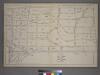
Plate 14: [Bounded by Sheridan Ave., Elliott Ave., Webster Ave., Brook Ave., E. 163rd St., Courtlandt Ave. and E. 162nd St.]
from Atlas of the city of New York : from official records, private plans & actual surveys / compiled under the supervision of E. Robinson & R. H. Pidgeon.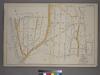
Part of the 23rd Ward, New York City.
from Atlas of the city of New York : from official records, private plans & actual surveys / compiled under the supervision of E. Robinson & R. H. Pidgeon.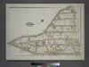
Plate 42, Part of Section 11, Borough of the Bronx. [Bounded by Boscobel Avenue, W. 172nd Street and Jerome Avenue.]
from Atlas of borough of the Bronx, Sections 9 10 11 12 & 13 : from actual surveys and official plans / G.W. Bromley and Co.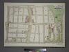
Plate 41, Part of Section 11, Borough of the Bronx. [Bounded by E. 172nd Street, Teller Avenue, E. 170th Street, Clay Avenue, E. 169th Street and Jerome Avenue.]
from Atlas of borough of the Bronx, Sections 9 10 11 12 & 13 : from actual surveys and official plans / G.W. Bromley and Co.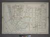
Plate 9: Part of Section 9, Borough of the Bronx. [Bounded by E. 165th Street, Sheridan Avenue, E. 158th Street, Walton Avenue, E. 157th Street, Exterior Street, Sedgwick Avenue and Lind Avenue.]
from Atlas and owners names, borough of the Bronx, sections 9 & 10 : from actual surveys and official plans / by George W. and Walter S. Bromley.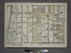
Plate 14, Part of Section 9, Borough of the Bronx. [Bounded by E. 165th Street, Walton Avenue, E. 166th Street, Morris Avenue, E. 161st Street and Jerome Avenue.]
from Atlas of borough of the Bronx, Sections 9 10 11 12 & 13 : from actual surveys and official plans / G.W. Bromley and Co.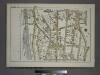
Plate 16, Part of Section 9, Borough of the Bronx. [Bounded by Depot Place, Sedgwick Avenue, Boscobel Avenue, Jerome Avenue, W. 166th Street and Harlem River.]
from Atlas of borough of the Bronx, Sections 9 10 11 12 & 13 : from actual surveys and official plans / G.W. Bromley and Co.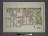
Plate 20, Part of Section 9, Borough of the Bronx. [Bounded by E. 169th Street, Third Avenue, E. 167th Street and Grant Avenue.]
from Atlas of borough of the Bronx, Sections 9 10 11 12 & 13 : from actual surveys and official plans / G.W. Bromley and Co.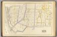
9, ward 23.
1 : 1800 Bromley, George Washington; Bromley, Walter Scott; G.W. Bromley & Co.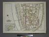
Plate 15, Part of Section 9, Borough of the Bronx. [Bounded by W. 166th Street, Jerome Avenue and Sedgwick Avenue]
from Atlas of borough of the Bronx, Sections 9 10 11 12 & 13 : from actual surveys and official plans / G.W. Bromley and Co.
Bronx, V. 10, Plate No. 75 [Map bounded by Nelson Ave., Inwood Ave., W. 169th St.]
From Atlas 49. Vol. 10, pt. 2, 1909.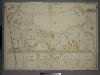
Double Page Plate No. 2, Part of Ward 24, Sections 9&11. [Bounded by Nelson Avenue, Featherbed Lane, E. 174th Street, Walton Avenue, Elliot Place, Jemorem Avenue, E. 170th Street and Boscobel Avenue.]
from Atlas of the borough of the Bronx, city of New York : based upon official plans and maps on file in the various city offices; supplemented by careful field measurements and personal observations, by and under the supervision of Hugo Ullitz.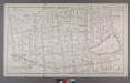
Section 9 of Final Maps and Profiles, of the 23rd & 24th Wards.
from Maps or plans and profiles, with field notes and explanatory remarks, showing the location, width, grades, and class of streets, roads, avenues, public squares and places, located and laid out by the Commissioner of Street Improvements of the 23rd and 24th wards of the city of New York : under authority of Chapter 545 of the laws of 1890.
Plate 35: Bounded by .....N. Third Avenue, 161st Street, Jerome Avenue, Harlem River and Depot Place.
from Atlas of the city of New York : embracing all territory within its corporate limits from official records, private plans & actual surveys / by and under the supervision of E. Robinson & R.H. Pidgeon, civil engineers.
Plate 6: Map No. 141 [Bounded by James Street, (Wm. Morris Farm), Rail Road Avenue, Prospect Street, Juliet Street, Gerard Street, Henry Street and River Avenue.]- Map No. 286 {Bounded by James WElls Land, Mill Brook, Henry Street and Morse Avenue or Old
from Certified copies of important maps appertaining to the 23rd and 24th wards, City of New York, filed in the Register's office at White Plains, County of Westchester, New York ...
Bronx, Topographical Map Sheet 11; [Map bounded by Union Ave., Tinton Ave., Westchester Ave., Eacle Ave., St. Ann's Ave., Rae St., Cerman PL., Brook Ave., Bercen Ave., 3rd Ave.; Including 153rd St., Rail Road Ave. East, Sheridan Ave., Mott Ave., Walto...
From Topographical map made from surveys by the commissioners of the Department of Public Parks of the City of New York of that part of Westchester County adjacent to the City and County of New York embraced by chapter 534 of laws of 1871 as amended b...
Bronx, Topographical Map Sheet 8; [Map bounded by Buchanan PL., 4th St., Webster Ave., Grove St., 3rd Ave., Quarry Road, Boston Road; Including 170th St., Elliot St., Findlay Ave., Mott Ave., Jerome Ave., 1st Ave., Macombs Dam Road]
From Topographical map made from surveys by the commissioners of the Department of Public Parks of the City of New York of that part of Westchester County adjacent to the City and County of New York embraced by chapter 534 of laws of 1871 as amended b...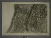
3C - N.Y. City (Aerial Set).
from Sectional aerial maps of the City of New York / [photographed and assembled under the direction of the chief engineer, July 1st, 1924].
Plate 16: Tremont, Town of West Farms, Westchester Co. N.Y.
from County atlas of Westchester, New York. Published by J.B. Beers & Co., assisted by S.W. Wilson and others.
Bronx, V. 12, Double Page Plate No. 270 [Map bounded by E. 198th St., Webster Ave., E. 193rd St., Kingsbridge Rd., Jerome Ave.]
From Atlas 50. Vol. 12, 1896.
Section 8 of Final Maps and Profiles, of the 23rd & 24th Wards.
from Maps or plans and profiles, with field notes and explanatory remarks, showing the location, width, grades, and class of streets, roads, avenues, public squares and places, located and laid out by the Commissioner of Street Improvements of the 23rd and 24th wards of the city of New York : under authority of Chapter 545 of the laws of 1890.
Plate 9: Tremont : Town of West Farms.
from Atlas of New York and vicinity : from actual surveys / by and under the direction of F. W. Beers, assisted by A. B. Prindle & others
Bronx, Topographical Map Sheet 10; [Map bounded by Anderson Ave., Jerome Ave.; Including 7th Ave., 149th St., River St.]
From Topographical map made from surveys by the commissioners of the Department of Public Parks of the City of New York of that part of Westchester County adjacent to the City and County of New York embraced by chapter 534 of laws of 1871 as amended b...
8, ward 23.
1 : 1800 Bromley, George Washington; Bromley, Walter Scott; G.W. Bromley & Co.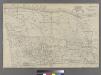
![Plate 18, Part of Section 9, Borough of the Bronx. [Bounded by E. 169th Street, Grant Avenue, E. 166th Street and Shakespeare Avenue.]](https://images-2.georeferencer.com/images/iiif/939731325857/full/,300/0/native.jpg)

