Maps of Bronx County

Plate 17: Part of Section 10, Borough of the Bronx. [Bounded by Coster Street, Edgewater Road, East Bay Avenue, Cabot Street, Leggett Avenue, Garrison Avenue, E. 156th Street, Barry Street, Worthen Street, Truxton Street, Tiffany Street and Spofford Aven
from Atlas and owners names, borough of the Bronx, sections 9 & 10 : from actual surveys and official plans / by George W. and Walter S. Bromley.
Plate 32: Part of Section 10, Burrough of the Bronx [Bounded by Burnnet Pl., Tiffany St., Oak Point Ave., (the East River), Cabot St., Garrison St., Longwood Ave., and Leggett Ave.
from Atlas of borough of the Bronx, Sections 9 10 11 12 & 13 : from actual surveys and official plans / G.W. Bromley and Co.
Plate 31, Part of Section 10, Borough of the Bronx. [Bounded by Longfellow Avenue, East Bay Avenue, Tiffany Street and Lafayette Avenue.]
from Atlas of borough of the Bronx, Sections 9 10 11 12 & 13 : from actual surveys and official plans / G.W. Bromley and Co.
Plate 33, Part of Section 10, Borough of the Bronx. [Bounded by Longfellow Avenue, Ryawa Avenue, Barretto Street, Tiffany Street and East Bay Avenue.]
from Atlas of borough of the Bronx, Sections 9 10 11 12 & 13 : from actual surveys and official plans / G.W. Bromley and Co.
17, ward 23.
1 : 2400 Bromley, George Washington; Bromley, Walter Scott; G.W. Bromley & Co.
Section 4 of Final Maps and Profiles, of the 23rd & 24th Wards.
from Maps or plans and profiles, with field notes and explanatory remarks, showing the location, width, grades, and class of streets, roads, avenues, public squares and places, located and laid out by the Commissioner of Street Improvements of the 23rd and 24th wards of the city of New York : under authority of Chapter 545 of the laws of 1890.
36. Ward 23.
1 : 7200 G.W. Bromley & Co.; Geo. W. Bromley & E. Robinson
Plate 25, Part of Section 10, Borough of the Bronx. [Bounded by E. 141st Street, Whitlock Avenue, Leggett Avenue, Cabot Street and East River.]
from Atlas of borough of the Bronx, Sections 9 10 11 12 & 13 : from actual surveys and official plans / G.W. Bromley and Co.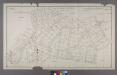
Section 3 of Final Maps and Profiles, of the 23rd & 24th Wards.
from Maps or plans and profiles, with field notes and explanatory remarks, showing the location, width, grades, and class of streets, roads, avenues, public squares and places, located and laid out by the Commissioner of Street Improvements of the 23rd and 24th wards of the city of New York : under authority of Chapter 545 of the laws of 1890.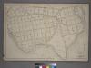
Plate 21: [Bounded by Winslow St., Tiffany St., Grinnell Pl., Hunts Point Ave., Sacrahong St., Strain Pl., Edgewater Rd., Ely St., Coster Ave., Casanova St. and Conover Ave.]
from Atlas of the city of New York : from official records, private plans & actual surveys / compiled under the supervision of E. Robinson & R. H. Pidgeon.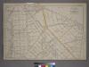
Plate 19: [Bounded by Bungay St., Southern Blvd., Prospect Ave., Dongan St., Fox St., Barretto St., Wetmore Ave.,Tiffany St., Craven St., Bacon St., Winslow St., Conover Ave. and Edgewater Road.]
from Atlas of the city of New York : from official records, private plans & actual surveys / compiled under the supervision of E. Robinson & R. H. Pidgeon.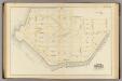
18, ward 23.
1 : 2400 Bromley, George Washington; Bromley, Walter Scott; G.W. Bromley & Co.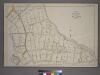
Plate 20: [Bounded by Dongan Ave., Edgewater Rd., Strain Pl., Sacrahong St., Grinnell Pl., Tiffany St., Winslow St., Bacon St., Craven St., Tiffany St., Wetmore Ave., Barretto St. and Southern Boulevard.]
from Atlas of the city of New York : from official records, private plans & actual surveys / compiled under the supervision of E. Robinson & R. H. Pidgeon.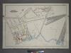
Plate 5: Part of Section 10, Borough of the Bronx. [Bounded by Southern Boulevard, St. Josephs Street, Timpson Place, E. 149th Street, Whitlock Avenue, E. 141st Street, Locust Avenue and E. 138th Street.]
from Atlas and owners names, borough of the Bronx, sections 9 & 10 : from actual surveys and official plans / by George W. and Walter S. Bromley.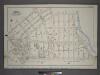
Plate 16: Part of Section 10, Borough of the Bronx. [Bounded by Garrison Avenue, Faile Street, Whitlock Avenue, Southern Boulevard, Longwood Avenue, Garrison Avenue, E. 156th Street, Worthen Street, Garisson Square and Spofford Avenue.]
from Atlas and owners names, borough of the Bronx, sections 9 & 10 : from actual surveys and official plans / by George W. and Walter S. Bromley.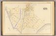
16, ward 23.
1 : 2400 Bromley, George Washington; Bromley, Walter Scott; G.W. Bromley & Co.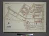
Plate 26, Part of Section 10, Borough of the Bronx. [Bounded by Southern Boulevard, Avenue St. John, Kelly Street, Leggett Avenue, Dawson Street, Longwood Avenue, Garrison Avenue, Leggett Avenue, Whitlock Avenue and E. 149th Street.]
from Atlas of borough of the Bronx, Sections 9 10 11 12 & 13 : from actual surveys and official plans / G.W. Bromley and Co.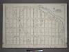
Plate 18: Part of Section 10, Borough of the Bronx. [Bounded by Spofford Avenue, Edgewater Road, Viele Avenue and Coster Street.]
from Atlas and owners names, borough of the Bronx, sections 9 & 10 : from actual surveys and official plans / by George W. and Walter S. Bromley.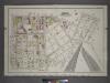
Plate 6: Part of Section 10, Borough of the Bronx. [Bounded by E. 156th Street, Southern Boulevard, Longwood Avenue, Garrison Street, Whitlock Street, Austin Place, E. 149th Street, Timpson Place, E. 147th Street, Union Avenue, Dater Street and Trinity A
from Atlas and owners names, borough of the Bronx, sections 9 & 10 : from actual surveys and official plans / by George W. and Walter S. Bromley.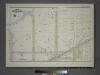
Plate 35, Part of Section 10, Borough of the Bronx. [Bounded by Farragut Street, East Bay Avenue, Longfellow Avenue, and Lafayette Avenue.]
from Atlas of borough of the Bronx, Sections 9 10 11 12 & 13 : from actual surveys and official plans / G.W. Bromley and Co.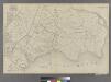
Part of Ward 23, New York City.
from Atlas of the city of New York : embracing all territory within its corporate limits from official records, private plans & actual surveys / by and under the supervision of E. Robinson & R.H. Pidgeon, civil engineers.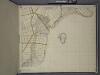
Bronx, Topographical Map Sheet 15; [Map bounded by 151 St., Southern Blvd., 149th St., Whitlock Ave., Wetmore Ave.; Including Edgewater Road, Cypress Ave., Powers Ave., Robbins Ave.]
From Topographical map made from surveys by the commissioners of the Department of Public Parks of the City of New York of that part of Westchester County adjacent to the City and County of New York embraced by chapter 534 of laws of 1871 as amended b...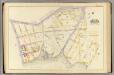
3, ward 23.
1 : 1800 Bromley, George Washington; Bromley, Walter Scott; G.W. Bromley & Co.
6B - N.Y. City (Aerial Set).
from Sectional aerial maps of the City of New York / [photographed and assembled under the direction of the chief engineer, July 1st, 1924].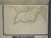
Bronx, Topographical Map Sheet 13; [Map bounded by Cdgewater Road, Halleck St., Coster Ave.; Including Payne St., Barlow St., Falconer St.]
From Topographical map made from surveys by the commissioners of the Department of Public Parks of the City of New York of that part of Westchester County adjacent to the City and County of New York embraced by chapter 534 of laws of 1871 as amended b...
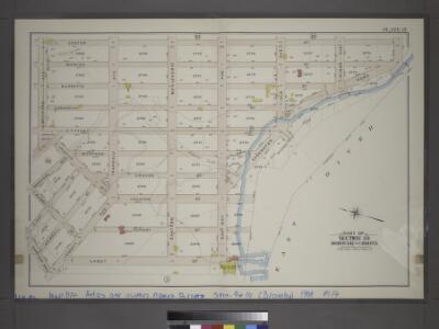
Area District Map Section No. 6; Area district map / City of New York, Board of Estimate and Apportionment.
from Area district map / City of New York, Board of Estimate and Apportionment. New York (N.Y.). Board of Estimate and Apportionment,
Height District Map Section No. 6; Height district map / City of New York, Board of Estimate and Apportionment.
from Height district map / City of New York, Board of Estimate and Apportionment. New York (N.Y.). Board of Estimate and Apportionment,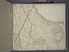
Bronx, Topographical Map Sheet 12; [Map bounded by Foote Ave., Maple Coster St., Maxwell Conover St., Wenman Ave., Randall Ave.; Including Wetmore Ave., Whitlock Ave., Southern Blvd., Fox St., Prospect Ave., Union Ave., Beck St.]
From Topographical map made from surveys by the commissioners of the Department of Public Parks of the City of New York of that part of Westchester County adjacent to the City and County of New York embraced by chapter 534 of laws of 1871 as amended b...
6D - N.Y. City (Aerial Set).
from Sectional aerial maps of the City of New York / [photographed and assembled under the direction of the chief engineer, July 1st, 1924].