Maps of Kings County
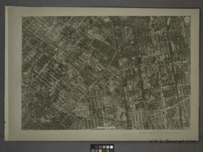
22D - N.Y. City (Aerial Set).
from Sectional aerial maps of the City of New York / [photographed and assembled under the direction of the chief engineer, July 1st, 1924].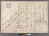
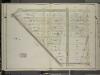
Plate 24: [Bounded by Avenue I, Ocean Avenue, Avenue O, 22nd Avenue, Bay Ridge Street, 21st Avenue and West Street.]
from Robinson's atlas of Kings County, New York : compiled from official records ... / under the direction of E. Robinson.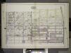
Brooklyn, Vol. 2, Double Page Plate No. 15; Part of Ward 30, Section 17; [Map bounded by 55th St., 44th St., Avenue K; Including 22nd Ave., 66th St., 15th Ave.] / by and under the direction of Hugo Ullitz.
From Volume 2.
Plate 15: [Bounded by 58th Street, Twentyfirst Avenue, 72nd Street and Fourteenth Avenue.]
from Robinson's atlas of Kings County, New York : compiled from official records ... / under the direction of E. Robinson.
Part of Wards 30 & 31, Land Map Sections, Nos. 17 & 19. Volume 2, Brooklyn Borough, New York City.
from Atlas of the Brooklyn borough of the City of New York : originally Kings Co.; complete in three volumes ... based upon official maps and plans ... / by and under the supervision of Hugo Ullitz, C.E.
Double Page Plate No. 13: [Bounded by Seventeenth Avenue, 48th Street, Nineteenth Avenue, Washington Avenue, Gravesend Avenue, Elmwood Street, East 2nd Street, Avenue I, Ocean Parkway, Avenue J, Gravesend Avenue, Twenty Second Avenue and 65th Street.]
from Atlas of the Brooklyn borough of the City of New York : originally Kings Co.; complete in three volumes ... based upon official maps and plans ... / by and under the supervision of Hugo Ullitz, C.E.
Part of the Town of New Utrecht, Kings Co., N.Y.
from Robinson's atlas of Kings County, New York : compiled from official records ... / under the direction of E. Robinson.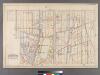
Part of the Town of Gravesend, Kings Co., N.Y.
from Robinson's atlas of Kings County, New York : compiled from official records ... / under the direction of E. Robinson.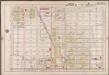
Plate 9: [Bounded by 72nd Street, 21st Avenue, 88th Street and 14th Avenue.]; Atlas of the borough of Brooklyn, city of New York: from actual surveys and official plans by George W. and Walter S. Bromley.
from Atlas of the borough of Brooklyn, city of New York : from actual surveys and official plans by George W. and Walter S. Bromley. G.W. Bromley & Co.,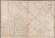
Plate 13: [Bounded by 72nd Street, 22nd Avenue, W. 11th Street, Avenue P, W. 7th Street, Avenue Q, W. 5th Street, Avenue R, W. 3rd St., Lloyd Court, Van Sicklen Street, Avenue D, Gravesend Avenue, Avenue U, W. 6th Street, Avenue V, 86th Street and 21st Avenue]; Atlas of the borough of Brooklyn, city of New York: from actual surveys and official plans by George W. and Walter S. Bromley.
from Atlas of the borough of Brooklyn, city of New York : from actual surveys and official plans by George W. and Walter S. Bromley. G.W. Bromley & Co.,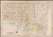
Plate 14: [Bounded by 86th Street, W. 11th Street, 27th Avenue, Warehouse Avenue & 20th Avenue.]; Atlas of the borough of Brooklyn, city of New York: from actual surveys and official plans by George W. and Walter S. Bromley.
from Atlas of the borough of Brooklyn, city of New York : from actual surveys and official plans by George W. and Walter S. Bromley. G.W. Bromley & Co.,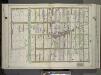
Brooklyn, Vol. 3, Double Page Plate No. 8; Part of Ward 31, Section 20; [Map bounded by Avenue O, Ocean Ave.; Including Avenue S, E. 2nd St.] / by and under the direction of Hugo Ullitz.
From Volume 3
Double Page Plate No. 21: [Bounded by 66th Street, Seventeenth Avenue, 65th Street, (Old Road from Flatbush to New Utrecht) Eighteenth Avenue, 81st Street and Twelfth Avenue.]
from Atlas of the Brooklyn borough of the City of New York : originally Kings Co.; complete in three volumes ... based upon official maps and plans ... / by and under the supervision of Hugo Ullitz, C.E.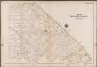
Plate 12: [Bounded by 58th Street, West Street, Avenue M., Gravesend Avenue, Avenue S., Van Sicklen Street, Lloyd Court, W. 3rd Street, Avenue R., W. 5th Street, Avenue Q, W. 7th Street, Avenue P, W. 11th Street, 22nd Ave., 72nd Street and 21st Avenue]; Atlas of the borough of Brooklyn, city of New York: from actual surveys and official plans by George W. and Walter S. Bromley.
from Atlas of the borough of Brooklyn, city of New York : from actual surveys and official plans by George W. and Walter S. Bromley. G.W. Bromley & Co.,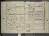
Brooklyn, Vol. 6, Double Page Plate No. 19; Part of Ward 30, Sections 17 & 19; [Map bounded by 62nd St., 22nd Ave.; Including 70th St., 18th Ave.]
from Ward 30.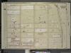
Brooklyn, Vol. 6, Double Page Plate No. 5; Part of Ward 30, Section 17; [Map bounded by 53rd St., West St., Gravesend Ave., Avenue K; Including 22nd Ave., 62nd St., 18th Ave.]
from Ward 30.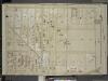
Brooklyn, Vol. 6, Double Page Plate No. 6; Part of Ward 30, Section 17; [Map bounded by 18th Ave., 67th St.; Including 15th Ave., 55th St.]
from Ward 30.
Brooklyn, Vol. 6, Double Page Plate No. 20; Part of Ward 30, Section 19; [Map bounded by 70th St., 22nd Ave.; Including 78th St., 18th Ave.]
from Ward 30.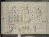
Brooklyn, Vol. 6, Double Page Plate No. 18; Part of Ward 30, Sections 17 & 19; [Map bounded by 18th Ave., 68th St.; Including 15th Ave., 67th St.]
from Ward 30.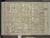
Brooklyn, Vol. 6, Double Page Plate No. 22; Part of Ward 30, Section 19; [Map bounded by 20th Ave., Benson Ave., Ruthrford Pl.; Including 17th Ave., New Utrech Ave., 78th St.]
from Ward 30.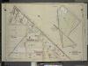
Brooklyn, Vol. 6, Double Page Plate No. 4; Part of Wards 30 & 31, Section 17; [Map bounded by Gravesend Ave., 53rd St.; Including 18th Ave.]; Sub Plan; [Map bounded by Ocean Parkway, Avenue L, Avenue M, West St.; Including 58th St., Avenue K (
from Ward 30.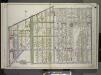
Brooklyn, Vol. 3, Double Page Plate No. 1; Part of Wards 30, 31 & 32, Section 20; [Map bounded by Foster Ave., Avenue G, Ocean Ave.; Including Avenue K, Ocean Parkway, Grave Send Ave.] / by and under the direction of Hugo Ullitz.
From Volume 3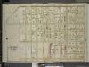
Brooklyn, Vol. 6, Double Page Plate No. 21; Part of Wards 30 & 31, Section 19; [Map bounded by 23rd Ave., Benson Ave., 20th Ave., 28th St.; Including 22nd Ave., Avenue P, Stillwell Ave.]
from Ward 30.
Plate 14: [Bounded by 39th Street, West Street, Twentyfirst Avenue, 58th Street and Fourteenth Avenue.]
from Robinson's atlas of Kings County, New York : compiled from official records ... / under the direction of E. Robinson.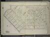
Brooklyn, Vol. 7, Double Page Plate No. 8; Part of Ward 31, Section 20; [Map bounded by Gravesend Ave., Avenue P, W. 6th St.; Including 65th St., 32nd St., 58th St., Avenue M]
from Ward 31.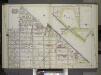
Brooklyn, Vol. 2, Double Page Plate No. 13; Part of Wards 29, 30 & 31, Section 16 & 17; [Map bounded by West St., 18th Ave., Ocean Parkway, Avenue L, Gravesend Ave., Avenue K, Avenue J; Including 54th St., 55th St., 15th Ave., 45th St., 16th Ave.] / b...
From Volume 2.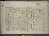
Brooklyn, Vol. 7, Double Page Plate No. 6; Part of Wards 30 & 31, Section 20; [Map bounded by Avenue M, Ocean Ave.; Including Avenue O, E. 9th St.]
from Ward 31.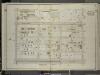
Brooklyn, Vol. 7, Double Page Plate No. 5; Part of Ward 31, Section 20; [Map bounded by E. 13th St., Avenue M; Including Ocean Parkway, Avenue J]
from Ward 31.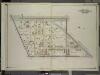
Brooklyn, Vol. 7, Double Page Plate No. 1; Part of Wards 30 & 31, Section 20; [Map bounded by Ocean Parkway, Avenue K; Including Gravesend Ave., Foster Ave.]
from Ward 31.