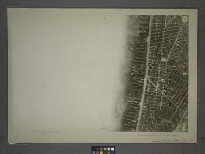
Maps of Hoboken
12A - N.Y. City (Aerial Set).
from Sectional aerial maps of the City of New York / [photographed and assembled under the direction of the chief engineer, July 1st, 1924].
Hudson River Vehicular Tunnel [Holland Tunnel]
From Manhattan
[Volume 1 Index Map]
from Maps of the city of New York.
Map showing the high and low water mark and the original city grants of lands under water made to various parties from 1686 to 1873, extending from Battery to Fifty-first Street, Hudson and East Rivers, New York City, also the several pier and bulkhead l
from Whole
Map showing the old high water lines along the shores of Brooklyn & New York together the the pier lines as established by law.
From Manhattan
The city of New York / Will L. Taylor, chief draughtsman.
from Whole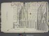
Jersey City.
from Combined atlas of the State of New Jersey and the County of Hudson : from actual survey, official records & private plans / by and under the direction of G. M. Hopkins ...
Map of the city of New-York extending northward to Fiftieth St. / surveyed and drawn by John F. Harrison, C.E.
from Manhattan
Sheet 5:[Bounded by Morton Street, Washington Street, Leroy Street, Hudson Street, Clarkson Street, Varick Street, Houston Street, Bowery Street, Chatham Square, Chatham Street, Reade Street and Washington Street.]
from Plan of New York City, from the Battery to Spuyten Duyvil Creek. Showing every lot and building thereon; old farm lines, strreet numbers at the corners of blocks, railroads, steamboat landings, bulkhead and pier lines, etc. Based on the surveys made by Messrs. Randall & Blackwell, and on the special survey by J. F. Harrison.
Part of Section 1 : New York City .
from Atlas of the city of New York, borough of Manhattan. From actual surveys and official plans / by George W. and Walter S. Bromley.
Map showing the high and low water mark and the original city grants of lands under water made to various parties from 1686 to 1873, extending from Battery to Fifty-first Street, Hudson and East Rivers, New York City, also the several pier and bulkhead l
from Whole
Sheet 6: [Bounded by W. Twentieth Street, Sixth Avenue, Carmine Street, Bleecker Street, Hancock Street, W. Houston Street, Varick Street, Charlton Street, Hudson Street, King Street, West Street and 10th Avenue.]
from Plan of New York City, from the Battery to Spuyten Duyvil Creek. Showing every lot and building thereon; old farm lines, strreet numbers at the corners of blocks, railroads, steamboat landings, bulkhead and pier lines, etc. Based on the surveys made by Messrs. Randall & Blackwell, and on the special survey by J. F. Harrison.
Jersey City, V. 1, Double Page Plate No. 6 [Map bounded by Provost St., Ferry St., Hudson River, Morgan St., Henderson St.] / compiled under the direction of and published by G.M. Hopkins Co.
From V. 1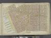
Manhattan, Double Page Plate No. 4 [Map bounded by Spring St., Broome St., Centre St., Pearl St., Thomas St., Jay St., Hudson River]
From Atlas of the city of New York, Manhattan Island. From actual surveys and official plans
[Plate 4: Bounded by Spring Street, Hudson Street, Broome Street, Centre Street, Pearl Street, Thomas Street, Hudson Street, Jay Sreet and [Hudson River, Piers 22-34] West Street.]
from Atlas of the city of New York, borough of Manhattan. From actual surveys and official plans / by George W. and Walter S. Bromley.
[Plate 9: Bounded by Charles Street, Washington Street, W. 10th Street, Hudson Street, Christopher Street, Bedford Street, Barrow Street, Bleecker Street, Cornelia Street, Sixth Avenue, W. 3rd Street, W. Broadway, Broome Street, Hudson Street, Spring Str
from Atlas of the city of New York, borough of Manhattan. From actual surveys and official plans / by George W. and Walter S. Bromley.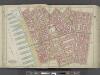
Manhattan, Double Page Plate No. 9 [Map bounded by Charles St., W. 3rd St., S. 5th Ave., Broome St., Hudson River]
From Atlas of the city of New York, Manhattan Island. From actual surveys and official plans
Part of Sections 1 & 2 : New York City.
from Atlas of the city of New York, Manhattan Island. From actual surveys and official plans / by George W. and Walter S. Bromley.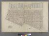
Part of Wards 5 & 8, New York City.
from Atlas of the city of New York : embracing all territory within its corporate limits from official records, private plans & actual surveys / by and under the supervision of E. Robinson & R.H. Pidgeon, civil engineers.
Plate 9: Bounded by Charles Street, Washington Street, W. 10th Street, Hudson Street, Christopher Street, Bedford Street, Barrow Street, Bleecker Street, Cornelia Street, Sixth Avenue, W. 3rd Street, W. Broadway, Broome Street, Hudson Street, Spring Stre
from Atlas of the city of New York, Manhattan Island. From actual surveys and official plans / by George W. and Walter S. Bromley.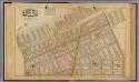
3. Wards 5, 8.
1 : 2400 G.W. Bromley & Co.; Geo. W. Bromley & E. Robinson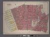
New York City, part of Map of part of Section 1, including approach to the Brooklyn Bridge. Bounded by Hudson River and Mulberry Street, and by Walker and Vesey Streets.
From Manhattan
[Plate 10: Bounded by W. 14th Street, Sixth Avenue, Cornelia Street, Bleecker Street, Barrow Street, Bedford Street, Christopher Street, Hudson Street, W. 10th Street, Washington Street, Charles Street, and [Hudson River, Piers 48-55] West Street.]
from Atlas of the city of New York, borough of Manhattan. From actual surveys and official plans / by George W. and Walter S. Bromley.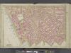
Manhattan, Double Page Plate No. 10 [Map bounded by W. 14th St., 6th Ave., Bedford St., Hudson River]
From Atlas of the city of New York, Manhattan Island. From actual surveys and official plans
[Plate 10: Bounded by W. 14th Street, Sixth Avenue, Cornelia Street, Bleecker Street, Barrow Street, Bedford Street, Christopher Street, Hudson Street, W. 10th Street, Washington Street, Charles Street, West Street (Hudson River, ???), Gansevoort Street,
from Atlas of the city of New York, Manhattan Island. From actual surveys and official plans / by George W. and Walter S. Bromley.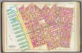
Pl. 9: wards 8-9 & 15.
1 : 1800 Bromley, George Washington; Bromley, Walter Scott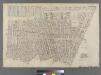
[Plate 10: Bounded by West Street (Hudson River, Piers 39-47), W. 11th Street, 13th Avenue (Hudson River, Piers [52?]-59), W. 14th Street, 7th Avenue, Greenwich Avenue, Perry Street, Waverly Place, Christopher Street, W. 4th Street, 6th Avenue, Bleecker
from Atlas of the city of New York : embracing all territory within its corporate limits from official records, private plans & actual surveys / by and under the supervision of E. Robinson & R.H. Pidgeon, civil engineers.
[Map bounded by Pier - Line 40-51, Christopher Street, Greenwich Street, Desbrosses Street; Including West Street, Washington Street, Watts Street, Hoboken Ferry, Hoboken St, Canal Street, Spring Street, Charlton Street, King Street, Hamme
from Maps of the wharves and piers on the Hudson and East rivers from the Battery to 13th St., New York.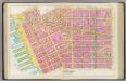
Pl. 4: wards 5-6, 8, 14.
1 : 1800 Bromley, George Washington; Bromley, Walter Scott