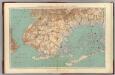
Maps of Kings County
General map of the city of New York, consisting of boroughs of Manhattan, Brooklyn, Bronx, Queens and Richmond : consolidated into one municipality by act of the legislature of the state of New York (Chapter 378 of the laws of 1897) : showing in addition
from Whole
Plate 28: Town of Jamaica.
from Atlas of Queens Co., Long Island, New York / compiled from official records, private plans & actual surveys by and under the direction of Chester Wolverton.
Index: Borough of Manhattan. Scale 1800 feet to the Inch. LEGEND, [Battery Park - 158th Street].
from Atlas of the city of New York, borough of Manhattan. From actual surveys and official plans / by George W. and Walter S. Bromley.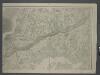
Map of New-York Bay and Harbor and the environs / founded upon a trigonometrical survey under the direction of F. R. Hassler, superintendent of the Survey of the Coast of the United States ; triangulation by James Ferguson and Edmund Blunt, assistants ;
from New York harbor
Jamaica.- Part of Hempstead, Tn. of Hempstead, Queens Co.
from Atlas of Long Island, New York. From recent and actual surveys and records.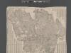
Street Indexed map of the Borough of Queens, also showing the Congressional Districts.
From Queens
Brooklyn
1 : 62500
Brooklyn
1 : 62500
Brooklyn
1 : 62500
Brooklyn
1 : 62500
Brooklyn
1 : 62500
Brooklyn
1 : 62500
Brooklyn
1 : 62500
Brooklyn
1 : 62500
Brooklyn
1 : 62500
Brooklyn
1 : 62500
Brooklyn
1 : 62500
Brooklyn
1 : 62500
Brooklyn
1 : 62500
Brooklyn
1 : 62500
New York City, County, and vicinity.
From Manhattan
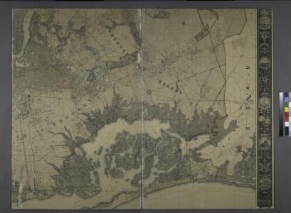
Map showing the old high water lines along the shores of Brooklyn & New York together the the pier lines as established by law.
From Manhattan
Guide map of Brooklyn, Kings County, N.Y. ....for Brooklyn daily eagle almanac.
From Brooklyn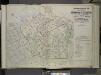
Index map to Volume Two Atlas of the Borough of Queens 1st and 2nd Wards City of New York, Published by E. Belcher Hyde, 5 Beekman St. (Temple Court) Manhattan. 97 Liberty St., Brooklyn Borough. 1908.
from First and second wards: Long Island City and Newtown.
Map of Brooklyn.
From Brooklyn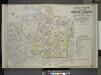
Index Map to Vol. 2, Atlas of the Borough of Queens, 1st and 2nd Wards City of New York Published by E. Belgher Hyde. 5 Beekman St. Temple Court Manhattan, 97 Liberty St. Brooklyn Borough. 1908
from Long Island City.
New Lots. Kings Co. L.I.
from Atlas of Long Island, New York. From recent and actual surveys and records.
Guide map of the borough of Brooklyn, Kings County, New York.
From Brooklyn
City of New York, Borough of Brooklyn ; map showing section stations, stables, and dumps.
From Brooklyn