Maps of Hudson County

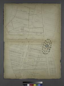
Sackersdorff Farm Set.
from Sackersdorf Farm Set.
Plate 43: Bounded by W. 20th Street, Broadway, [Washington Square], E. 14th Street, W. 14th Street, and Seventh Avenue.
from Atlas of the borough of Manhattan, city of New York.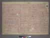
Plate 4, Part of Section 3: [Bounded by W. 20th Street, E. 20th Street, Broadway, Union Square, E. 14th Street, W. 14th Street and Seventh Avenue.]
from Atlas of the city of New York, borough of Manhattan. From actual surveys and official plans / by George W. and Walter S. Bromley.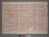
Plate 4, Part of Section 3: [Bounded by W. 20th Street, E. 20th Street, Second Avenue, Broadway, E. 14th Street, W. 14th Street and Seventh Avenue.]
from Atlas of the city of New York, borough of Manhattan. From actual surveys and official plans / by George W. and Walter S. Bromley.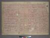
Plate 4, Part of Section 3: [Bounded by W. 20th Street, W. 20th Street, Broadway, Union Square, E. 14th Street, W. 14th Street and Seventh Avenue.]
from Atlas of the city of New York, borough of Manhattan. From actual surveys and official plans / by George W. and Walter S. Bromley.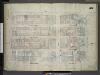
[Plate 45: Map bounded by West 18th Street, East 18th Street, Broadway, Union Square Street, East 14th Street, West 14th Street, Sixth Avenue; Including West 17th Street, East 17th Street, West 16th Street, East 16th Street, West 15th Street, East
from Insurance maps of the city of New York.
Plate 56: Map bounded by West 22nd Street, East 22nd Street, Fourth Avenue, Union Place, East 17th Street, Broadway, West 18th Street, Sixth Avenue.
from Maps of the city of New York / surveyed under directions of insurance companies of said city.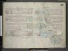
[Plate 48: Map bounded by West 22nd Street, East 22nd Street, Fourth Avenue, Union Place, East 17th Street, Broadway, East 18th Street, West 18th Street, Sixth Avenue; Including West 21st Street, East 21st Street, West 20th Street, East 20th
from Insurance maps of the city of New York.
Plate 48: Map bounded by West 22nd Street, East 22nd Street, Fourth Avenue, Union Square North, Broadway, East 18th Street, West 18th Street, Sixth Avenue
from Maps of the city of New York.
Plate 45: Map bounded by West 18th Street, East 18th Street, Broadway, Union Square West, East 14th Street, West 14th Street, Sixth Avenue
from Maps of the city of New York.
Plate 53: Map bounded by West 18th Street, East 18th Street, Broadway, Union Place, East 14th Street, West 14th Street, Sixth Avenue.
from Maps of the city of New York / surveyed under directions of insurance companies of said city.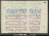
Manhattan, V. 3, Double Page Plate No. 58 [Map bounded by E. 14th St., University Pl., E. 10th St., W. 10th St., 6th Ave., W. 14th St.]
From Atlas 42.53. Vol. 3, 1895.
Part of Section 3 : Plate 44.
from Atlas of the borough of Manhattan, city of New York.
Manhattan, V. 3, Plate No. 57 [Map bounded by University Pl., E. 14th St., 4th Ave., E. 12th St.]
From Atlas 42.53. Vol. 3, 1895.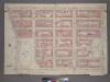
Plate 3, Part of Section 3: [Bounded by E. 20th Street, Second Avenue, E. 14th Street and Union Square and Broadway.]
from Atlas of the city of New York, borough of Manhattan. From actual surveys and official plans / by George W. and Walter S. Bromley.
Plate 58: Map bounded by 14th Street, University Place, 9th Street, Sixth Avenue
from Maps of the city of New York.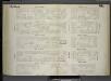
[Plate 66: Map bounded by West 14th Street, East 14th Street, University Place, East 9th Street, West 9th Street, Sixth Avenue.]
from Maps of the city of New York / surveyed under directions of insurance companies of said city.
Plate 57: Map bounded by 14th Street, Fourth Avenue, 9th Street, University Place
from Maps of the city of New York.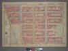
Plate 3, Part of Section 3: [Bounded by E. 20th Street, Second Avenue, E. 14th Street, Union Square - East Fourth Avenue, E. 17th Street and Broadway.]
from Atlas of the city of New York, borough of Manhattan. From actual surveys and official plans / by George W. and Walter S. Bromley.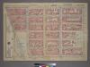
Plate 3, Part of Section 3: [Bounded by E. 20th Street, Second Avenue, E. 14th Street, Union Square and Broadway.]
from Atlas of the city of New York, borough of Manhattan. From actual surveys and official plans / by George W. and Walter S. Bromley.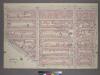
Plate 32, Part of Section 2: [Bounded by W. 14th Street, E. 14th Street, University Place, E. 8th Street, W. 8th Street, Greenwich Avenue and Seventh Avenue.]
from Atlas of the city of New York, borough of Manhattan. From actual surveys and official plans / by George W. and Walter S. Bromley.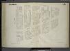
[Plate 65: Map bounded by University Place, East 14th Street, Fourth Avenue, East 9th Street.]
from Maps of the city of New York / surveyed under directions of insurance companies of said city.
Plate 52: Map bounded by East 17th Street, Second Avenue, East 12th Street, Bowery, Fourth Avenue.
from Maps of the city of New York / surveyed under directions of insurance companies of said city.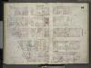
[Plate 44: Map bounded by East 17th Street, Second Avenue, East 12th Street, Fourth Avenue, Union Square East; Including East 16th Street, East 15th Street, East 14th Street, East 13th Street, Irving Place, Third Avenue, Rutherford Place]
from Insurance maps of the city of New York.
Manhattan, V. 2, Plate No. 33 [Map bounded by 6th Ave., W. 17th St., 5th Ave., W. 14th St.]
From Atlas 110. Vol. 2, 1903.
Manhattan, V. 2, Plate No. 41 [Map bounded by 6th Ave., W. 20th St., 5th Ave., W. 17th St.]
From Atlas 110. Vol. 2, 1903.
Manhattan, V. 2, Plate No. 43 [Map bounded by E. 22nd St., Broadway, E. 17th St., 5th Ave.]
From Atlas 110. Vol. 2, 1903.
Manhattan, V. 2, Plate No. 44 [Map bounded by E. 22nd St., 4th Ave., E. 17th St., Broadway]
From Atlas 110. Vol. 2, 1903.
Manhattan, V. 2, Plate No. 25 [Map bounded by E. 14th St., 3rd Ave., E. 10th St., 4th Ave.]
From Atlas 110. Vol. 2, 1903.