Maps of Richmond County
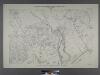
Sheet No. 91. [Includes Huguenot, Terra Marine Park (Wolf's Pond Park (Huguenot Beach) and Arbutus Lake.]
from Borough of Richmond, Topographical Survey.
Part of Westfield & Southfield.
from Atlas of Staten Island, Richmond County, New York, from official records and surveys; compiled and drawn by F. W. Beers.
Part of Ward 5. [Map bound by Barclay Ave, Raritan Bay, Poillon Ave (Harrison Ave), Arbutus Lake, Arbutus Ave (Broadway), Amboy Road]
from Atlas of the city of New York, borough of Richmond, Staten Island. From actual surveys and original plans, by George W. and Walter S. Bromley.
Part of Ward 5. [Map bound by Arbutus Ave (Broadway), Arbutus Lake, 5th St, Raritan Bay, Sycamore Ave, Androvette Ave, Amboy Road]
from Atlas of the city of New York, borough of Richmond, Staten Island. From actual surveys and original plans, by George W. and Walter S. Bromley.
Part of Wards 4 & 5. [Map bound by The Staten Island Railway Co., Seaside Ave, Southfield Boulevard, Bulkhead Line, Shore Road, Sycamore Ave, Androvette Ave, Amboy Road]
from Atlas of the borough of Richmond, city of New York.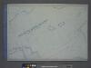
Use District Map Section No. 33; Use district map / City of New York, Board of Estimate and Apportionment.
from Use district map / City of New York, Board of Estimate and Apportionment. New York (N.Y.). Board of Estimate and Apportionment,
Area District Map Section No. 33; Area district map / City of New York, Board of Estimate and Apportionment.
from Area district map / City of New York, Board of Estimate and Apportionment. New York (N.Y.). Board of Estimate and Apportionment,
33C - N.Y. City (Aerial Set).
from Sectional aerial maps of the City of New York / [photographed and assembled under the direction of the chief engineer, July 1st, 1924].
33D - N.Y. City (Aerial Set).
from Sectional aerial maps of the City of New York / [photographed and assembled under the direction of the chief engineer, July 1st, 1924].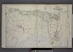
Part of Ward 5. [Map bound by The Staten Island Railway Co., Amboy Road, Holton St, Henry St, Seguine Ave, William St, Melville St, Wilbur St, Algernon St, Beach St, Pier & Bulkhead Line, Beach Ave]
from Atlas of the borough of Richmond, city of New York.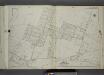
Part of Ward 5. [Map bound by Maguire Ave, Ramona Ave, Lamont Ave, Ionia Ave, Edgegrove Ave, Detroit Ave, Huguenot Ave, Thompson St, Cottage Ave, Staten Island Rail Road, Amboy Road, Seguine Ave, Wood Ave (Elmer Ave), Bay View Ave]
from Atlas of the city of New York, borough of Richmond, Staten Island. From actual surveys and original plans, by George W. and Walter S. Bromley.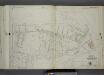
Part of Ward 5. [Map bound by Holton St, Henry St, Seguine Ave, William St, Melville St, Wilbur St, Algernon St, Johnson Terrace (Shore Ave), Lemon Creek, Bay View Ave, Finley Ave, Excelsior Ave, Manee Ave, Staten Island Rail Road]
from Atlas of the city of New York, borough of Richmond, Staten Island. From actual surveys and original plans, by George W. and Walter S. Bromley.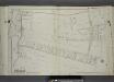
Part of Wards 4 & 5. [Map bound by Richmond Ave, (Eltingville Ave), South Side Boulevard, Wakefield Road, Raritan Bay, Ocean Driveway, Barclay Ave, Amboy Road, Arden Ave (Washington Ave), Staten Island R.R.]
from Atlas of the city of New York, borough of Richmond, Staten Island. From actual surveys and original plans, by George W. and Walter S. Bromley.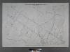
Borough of Richmond, Topographical Survey.
from Borough of Richmond, Topographical Survey.
Height District Map Section No. 33
from Height district map / City of New York, Board of Estimate and Apportionment.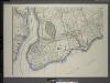
General map of the borough of Richmond (Staten Island) in the city of New York : showing in addition to the existing topographical features of the borough a tentative and preliminary plan for a street system of the same.
from Staten Island
Arthur Kill
1 : 24000
Arthur Kill
1 : 24000
Arthur Kill
1 : 24000
Arthur Kill
1 : 24000
Arthur Kill
1 : 24000
Arthur Kill
1 : 24000
Arthur Kill
1 : 24000
Staten Island South.
1 : 253440 Dripps, Matthew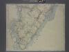
New map of Staten Island
from Staten Island
Richmond Co., Staten Island.
1 : 31680 Vermeule, C. C. (Cornelius Clarkson), 1858-1950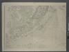
Map of New-York Bay and Harbor and the environs / founded upon a trigonometrical survey under the direction of F. R. Hassler, superintendent of the Survey of the Coast of the United States ; triangulation by James Ferguson and Edmund Blunt, assistants ;
from New York harbor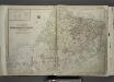
Outline & Index Map of The Borough of Richmond (Staten Island); Explanation; Note.
from Atlas of the city of New York, borough of Richmond, Staten Island. From actual surveys and original plans, by George W. and Walter S. Bromley.
Watson's new map of the city of Brooklyn including Brooklyn
From Brooklyn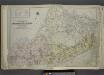
![Sheet No. 91. [Includes Huguenot, Terra Marine Park (Wolf's Pond Park (Huguenot Beach) and Arbutus Lake.]](https://images-2.georeferencer.com/images/iiif/348580505380/full/,300/0/native.jpg)

