Maps of Richmond County
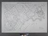
Sheet No. 78. [Includes Great Kills, Amboy Road, Midland Road, Great Kills Road, Highland Avenue, Southside Boulevard, Nelson Avenue, Duck Creek.]; Borough of Richmond, Topographical Survey.
from Borough of Richmond, Topographical Survey. Staten Island. Topographical Bureau.,
Part of Ward 4. [Map bound by Amboy Road, Cedarview Ave, Oak Ave, South Side Boulevard, 9th St, 14th St, Baldwin Ave (Jefferson Ave), Cole CT, Cole Place, Bay Terrace]
from Atlas of the city of New York, borough of Richmond, Staten Island. From actual surveys and original plans, by George W. and Walter S. Bromley.
Part of Ward 4. [Map bound by Richmond Road, Grand St, Clarke Ave, Amboy Road, Tysens St, Center St]
from Atlas of the city of New York, borough of Richmond, Staten Island. From actual surveys and original plans, by George W. and Walter S. Bromley.
Part of Ward 4. [Map bound by New Dorp Lane, New Dorp Beach, Lower Bay, Birch Ave, Brook Ave, Amboy Road, Richmond Road]
from Atlas of the borough of Richmond, city of New York.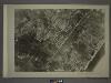
27C - N.Y. City (Aerial Set).
from Sectional aerial maps of the City of New York / [photographed and assembled under the direction of the chief engineer, July 1st, 1924].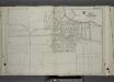
Part of Ward 4. [Map bound by Amboy Road, Bishop Ave, Dale Ave, Dorothea PL, Grace RD, Richmond Road, Locust Ave, 5th St, New Dorp Ave, 10th St, South Side Boulevard, Tysens Lane]
from Atlas of the city of New York, borough of Richmond, Staten Island. From actual surveys and original plans, by George W. and Walter S. Bromley.
Section 20
from Atlas of Staten Island, Richmond County, New York, from official records and surveys; compiled and drawn by F. W. Beers.
Part of Southfield & Middletown.
from Atlas of Staten Island, Richmond County, New York, from official records and surveys; compiled and drawn by F. W. Beers.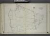
Part of Ward 4. [Map bound by Center St, Clarke Ave, St. Agnes Cemetery, Amboy Road, Staten Island R.R., Giffords Lane, Richmond Creek, Palmer Run, Arthur Kills Road (Fresh Kills RD)]
from Atlas of the city of New York, borough of Richmond, Staten Island. From actual surveys and original plans, by George W. and Walter S. Bromley.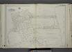
Part of Ward 4. [Map bound by Oak Ave, Mill Road, Kissam Ave, Lower New York Bay, Brook Ave, Mill Pond, South Side Boulevard]
from Atlas of the city of New York, borough of Richmond, Staten Island. From actual surveys and original plans, by George W. and Walter S. Bromley.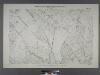
Borough of Richmond, Topographical Survey.
from Borough of Richmond, Topographical Survey.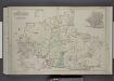
Part of Wards 2, 3, & 4. [Map bound by Forest Hill Road, New Road, Willow Brook Road, Manor Road, Ocean Terrace, Richmond Road, Amboy Road, Fresh Kills Road, Richmond Hill Road; Sub Plan - Summit Ave, Beacon Ave, Grand Ave, Walden PL, Pleasant
from Atlas of the borough of Richmond, city of New York.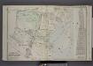
Part of Wards 4 & 5. [Map bound by Clarke Ave, Emmet Ave, Maple Ave, Lower Bay, Seaside Ave, Bridge Ave, Fresh Hills Road; Property of South New York Villa Site Co. - 1st St, Cortel You Ave, Fresh Kill Road, Richmond Ave, 21st St, Thompson Ave
from Atlas of the borough of Richmond, city of New York.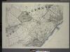
General map of the borough of Richmond (Staten Island) in the city of New York : showing in addition to the existing topographical features of the borough a tentative and preliminary plan for a street system of the same.
from Staten Island
Map of Staten Island o Richmond County. 16 views of buildings on border. Also view of Elliottville the property of Dr. S. M. Elliott.
From Staten Island
Staten Island South.
1 : 253440 Dripps, Matthew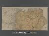
New Standard Map of the Borough of Richmond.
From Staten Island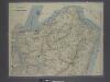
New map of Staten Island
from Staten Island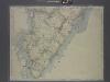
New map of Staten Island
from Staten Island
Richmond Co., Staten Island.
1 : 31680 Vermeule, C. C. (Cornelius Clarkson), 1858-1950
Map of property situated in the 12th ward of the city of New York belonging to the estate of John Taylor : to be sold at auction by Jas. Bleecker & Sons at the Merchts. Exchange at 12 o'clock on Tuesday the 1st April 1834.
from Manhattan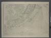
Map of New-York Bay and Harbor and the environs / founded upon a trigonometrical survey under the direction of F. R. Hassler, superintendent of the Survey of the Coast of the United States ; triangulation by James Ferguson and Edmund Blunt, assistants ;
from New York harbor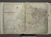
Outline & Index Map of The Borough of Richmond (Staten Island); Explanation; Note.
from Atlas of the city of New York, borough of Richmond, Staten Island. From actual surveys and original plans, by George W. and Walter S. Bromley.
City of New Manhattan : proposed May 1911, revised May 1930 / T. Kennard Thomson, consulting engineer, New York City.
from Manhattan
Watson's new map of the city of Brooklyn including Brooklyn
From Brooklyn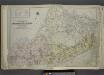
Outline & Index Map of The Borough of Richmond (Staten Island); Explanation; Note.
from Atlas of the city of New York, borough of Richmond, Staten Island. From actual surveys and original plans, by George W. and Walter S. Bromley.
Hammond's complete map of Staten Island, N.Y., Borough of Richmond, New York City.
From Staten Island
Map of a Richmond Borough Park System as recommended by the Committee on Parks of the Staten Island Chamber of Commerce.
From Staten Island
General map of the city of New York, consisting of boroughs of Manhattan, Brooklyn, Bronx, Queens and Richmond : consolidated into one municipality by act of the legislature of the state of New York (Chapter 378 of the laws of 1897) : showing in addition
from Whole
![Sheet No. 78. [Includes Great Kills, Amboy Road, Midland Road, Great Kills Road, Highland Avenue, Southside Boulevard, Nelson Avenue, Duck Creek.]; Borough of Richmond, Topographical Survey.](https://images-2.georeferencer.com/images/iiif/419928969481/full/,300/0/native.jpg)

