Maps of Richmond County
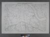
Sheet No. 59. [Includes Fresh Kills Road (Arthur Kills Road) Green Ridge and Richmond Creek.]; Borough of Richmond, Topographical Survey.
from Borough of Richmond, Topographical Survey. Staten Island. Topographical Bureau.,
26B - N.Y. City (Aerial Set).
from Sectional aerial maps of the City of New York / [photographed and assembled under the direction of the chief engineer, July 1st, 1924].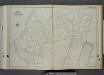
Part of Ward 3. [Map bound by Richmond Creek, Fresh Kills, Springville Flaak, Springville Creek, Travis Ave (Union), Richmond Ave (Bridge Ave) (Old Stone RD), Rockland Ave, Klondike Ave, Richmond Hill Road, Alaska PL, Yukon PL, Meadow Lane, M
from Atlas of the city of New York, borough of Richmond, Staten Island. From actual surveys and original plans, by George W. and Walter S. Bromley.
Section 14.
from Atlas of Staten Island, Richmond County, New York, from official records and surveys; compiled and drawn by F. W. Beers.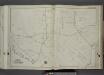
Part of Ward 3. [Map bound by Forest Hill Road (Old Mill Road), Richmond Hill Road, Klondike Ave, Rockland Ave (Saw Mill RD), Richmond Creek, Old Hill Road, Alaska PL]
from Atlas of the city of New York, borough of Richmond, Staten Island. From actual surveys and original plans, by George W. and Walter S. Bromley.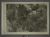
26D - N.Y. City (Aerial Set).
from Sectional aerial maps of the City of New York / [photographed and assembled under the direction of the chief engineer, July 1st, 1924].
Part of Northfield & Middletown.
from Atlas of Staten Island, Richmond County, New York, from official records and surveys; compiled and drawn by F. W. Beers.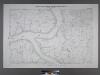
Borough of Richmond, Topographical Survey.
from Borough of Richmond, Topographical Survey.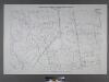
Sheet No. 68. [Includes (Green Ridge) Carleton Boulevard, Halpin Avenue, Legate Avenue and Annadale Road.]; Borough of Richmond, Topographical Survey.
from Borough of Richmond, Topographical Survey. Staten Island. Topographical Bureau.,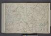
Part of Wards 3, 4, & 5. [Map bound by Cannon Ave, Burying Hill Road, Richmond Turnpike, Union Ave, Old Stone Road, Rockland Ave, Forest Hill Road, Fresh Kills Road, State Line; Lots at Linoleumville - Richmond Turnpike, Feldmeyer Lane]
from Atlas of the borough of Richmond, city of New York.
Height District Map Section No. 26; Height district map / City of New York, Board of Estimate and Apportionment.
from Height district map / City of New York, Board of Estimate and Apportionment. New York (N.Y.). Board of Estimate and Apportionment,
Use District Map Section No. 26; Use district map / City of New York, Board of Estimate and Apportionment.
from Use district map / City of New York, Board of Estimate and Apportionment. New York (N.Y.). Board of Estimate and Apportionment,
Area District Map Section No. 26
from Area district map / City of New York, Board of Estimate and Apportionment.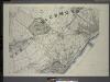
General map of the borough of Richmond (Staten Island) in the city of New York : showing in addition to the existing topographical features of the borough a tentative and preliminary plan for a street system of the same.
from Staten Island
Arthur Kill
1 : 24000
Arthur Kill
1 : 24000
Arthur Kill
1 : 24000
Arthur Kill
1 : 24000
Arthur Kill
1 : 24000
Arthur Kill
1 : 24000
Arthur Kill
1 : 24000
Map of Staten Island o Richmond County. 16 views of buildings on border. Also view of Elliottville the property of Dr. S. M. Elliott.
From Staten Island
Staten Island South.
1 : 253440 Dripps, Matthew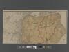
New Standard Map of the Borough of Richmond.
From Staten Island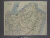
New map of Staten Island
from Staten Island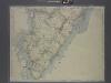
New map of Staten Island
from Staten Island
Richmond Co., Staten Island.
1 : 31680 Vermeule, C. C. (Cornelius Clarkson), 1858-1950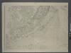
Map of New-York Bay and Harbor and the environs / founded upon a trigonometrical survey under the direction of F. R. Hassler, superintendent of the Survey of the Coast of the United States ; triangulation by James Ferguson and Edmund Blunt, assistants ;
from New York harbor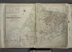
Outline & Index Map of The Borough of Richmond (Staten Island); Explanation; Note.
from Atlas of the city of New York, borough of Richmond, Staten Island. From actual surveys and original plans, by George W. and Walter S. Bromley.
![Sheet No. 59. [Includes Fresh Kills Road (Arthur Kills Road) Green Ridge and Richmond Creek.]; Borough of Richmond, Topographical Survey.](https://images-2.georeferencer.com/images/iiif/211254018753/full/,300/0/native.jpg)

